Maps of Câmpia Turzii

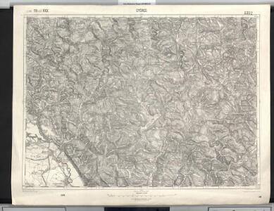
Gyéres
1 : 75000 Câmpia Turzii, Judeţ Klausenburg
Lambert-Cholesky sheet 3168 (Ceanul Mare)
1 : 20000 Romanian military topographic map sheet under Lambert-Cholensky projection Direcția Topografică Militară geo-spatial.org Direcția Topografică Militară
Lambert-Cholesky sheet 3167 (Câmpia Turzii)
1 : 20000 Romanian military topographic map sheet under Lambert-Cholensky projection Direcția Topografică Militară geo-spatial.org Direcția Topografică Militară
Lambert-Cholesky sheet 3268 (Miheşul de Câmpie)
1 : 20000 Romanian military topographic map sheet under Lambert-Cholensky projection Direcția Topografică Militară geo-spatial.org Direcția Topografică Militară
Lambert-Cholesky sheet 3267 (Sânger)
1 : 20000 Romanian military topographic map sheet under Lambert-Cholensky projection Direcția Topografică Militară geo-spatial.org Direcția Topografică Militară
Gyeres.
from Spezialkarte der osterreichisch-ungarischen Monarchie.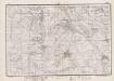
Lambert-Cholesky sheet 3169 (Suatul)
1 : 20000 Romanian military topographic map sheet under Lambert-Cholensky projection Direcția Topografică Militară geo-spatial.org Direcția Topografică Militară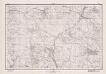
Lambert-Cholesky sheet 3269 (Balta)
1 : 20000 Romanian military topographic map sheet under Lambert-Cholensky projection Direcția Topografică Militară geo-spatial.org Direcția Topografică Militară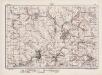
Lambert-Cholesky sheet 3367 (Band)
1 : 20000 Romanian military topographic map sheet under Lambert-Cholensky projection Direcția Topografică Militară geo-spatial.org Direcția Topografică Militară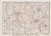
Lambert-Cholesky sheet 3368 (Sincai)
1 : 20000 Romanian military topographic map sheet under Lambert-Cholensky projection Direcția Topografică Militară geo-spatial.org Direcția Topografică Militară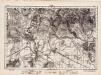
Lambert-Cholesky sheet 3266 (Luduş)
1 : 20000 Romanian military topographic map sheet under Lambert-Cholensky projection Direcția Topografică Militară geo-spatial.org Direcția Topografică Militară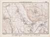
Lambert-Cholesky sheet 3166 (Luncani)
1 : 20000 Romanian military topographic map sheet under Lambert-Cholensky projection Direcția Topografică Militară geo-spatial.org Direcția Topografică Militară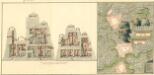
Plan deren Bergwerg Nagiay: i Offi und Bedas
Mollova mapová sbírka Geyer
Torda.
from Spezialkarte der osterreichisch-ungarischen Monarchie.
Maros-Vasarhely.
from Spezialkarte der osterreichisch-ungarischen Monarchie.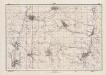
Lambert-Cholesky sheet 3369 (Ulieș)
1 : 20000 Romanian military topographic map sheet under Lambert-Cholensky projection Direcția Topografică Militară geo-spatial.org Direcția Topografică Militară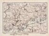
Lambert-Cholesky sheet 3366 (Şauşa)
1 : 20000 Romanian military topographic map sheet under Lambert-Cholensky projection Direcția Topografică Militară geo-spatial.org Direcția Topografică Militară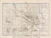
Lambert-Cholesky sheet 3067 (Turda)
1 : 20000 Romanian military topographic map sheet under Lambert-Cholensky projection Direcția Topografică Militară geo-spatial.org Direcția Topografică Militară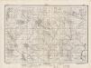
Lambert-Cholesky sheet 3068 (Aiton )
1 : 20000 Romanian military topographic map sheet under Lambert-Cholensky projection Direcția Topografică Militară geo-spatial.org Direcția Topografică Militară
Siebenbürgen
1 : 600000 Siebenbürgen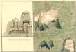
Plan des Bergwergs Weres Patack
Mollova mapová sbírka Geyer
Siebenbürgen
Sedmihradsko (Rumunsko) Kipferling, Karl Joseph im Verlage des Kunst und Industrie Comptoir's
Kolozsvár (Klausenburg), Máramaros-Sziget, Tölgyes
1 : 750000 Cluj-Napoca (Rumunsko) Erben, F. K. u. k. Militärgeographisches Institut
Kolozsvár (Klausenburg), Máramaros-Sziget, Tölgyes
1 : 750000 Cluj-Napoca (Rumunsko) Erben, F. K. u. k. Militärgeographisches Institut
Klausenburg, Máramaros-Sziget, Tölgyes
1 : 750000 K. u. k. militär-geographisches Institut
Klausenburg, Máramaros-Sziget, Tölgyes
1 : 750000 Cluj-Napoca (Rumunsko) K. k. militär-geographisches Institut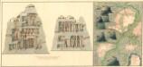
Plan dern Bergwerg bei Carlburg und Vardia
Mollova mapová sbírka Geyer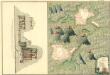
Plan von Bergwerg Pestian und Ivota
Mollova mapová sbírka Geyer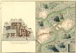
Plan der Bergwerg, Flod, Gilamare und Giogy
Mollova mapová sbírka Geyer