Maps of Zalau

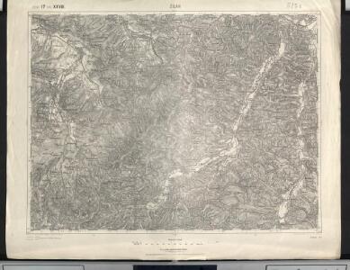
Zilah
1 : 75000 Zalău, Umland
Zilah.; Spezialkarte der osterreichisch-ungarischen Monarchie.
from Spezialkarte der osterreichisch-ungarischen Monarchie. Austro-Hungarian Monarchy. Militärgeographisches Institut.,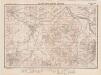
Lambert-Cholesky sheet 2674 (Zalău Vest)
1 : 20000 Romanian military topographic map sheet under Lambert-Cholensky projection Institutul Geografic Militar geo-spatial.org Institutul Geografic Militar
Lambert-Cholesky sheet 2673 (Căţăul Românesc)
1 : 20000 Romanian military topographic map sheet under Lambert-Cholensky projection Serviciul Geografic al Armatei geo-spatial.org Serviciul Geografic al Armatei
Lambert-Cholesky sheet 2774 (Zalău Est)
1 : 20000 Romanian military topographic map sheet under Lambert-Cholensky projection Institutul Geografic Militar geo-spatial.org Institutul Geografic Militar
Lambert-Cholesky sheet 2773 (Trăznea)
1 : 20000 Romanian military topographic map sheet under Lambert-Cholensky projection Serviciul Geografic al Armatei geo-spatial.org Serviciul Geografic al Armatei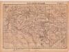
Lambert-Cholesky sheet 2772 (Sânta Maria)
1 : 20000 Romanian military topographic map sheet under Lambert-Cholensky projection Serviciul Geografic al Armatei geo-spatial.org Serviciul Geografic al Armatei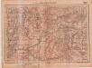
Lambert-Cholesky sheet 2672 (Bucium)
1 : 20000 Romanian military topographic map sheet under Lambert-Cholensky projection Serviciul Geografic al Armatei geo-spatial.org Serviciul Geografic al Armatei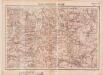
Lambert-Cholesky sheet 2874 (Gâlgău(jud. Sălaj))
1 : 20000 Romanian military topographic map sheet under Lambert-Cholensky projection Serviciul Geografic al Armatei geo-spatial.org Serviciul Geografic al Armatei
Lambert-Cholesky sheet 2873 (Sânpetru)
1 : 20000 Romanian military topographic map sheet under Lambert-Cholensky projection Serviciul Geografic al Armatei geo-spatial.org Serviciul Geografic al Armatei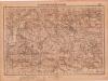
Lambert-Cholesky sheet 2872 (Drag)
1 : 20000 Romanian military topographic map sheet under Lambert-Cholensky projection Serviciul Geografic al Armatei geo-spatial.org Serviciul Geografic al Armatei
Szilágy vármegye térképe
1 : 360000 Kogutowicz, Manó Magyar Földrajzi Intézet
Banffy-Hunyad (Ungarn).
from Spezialkarte der osterreichisch-ungarischen Monarchie.
Alparet [Olpret].
from Spezialkarte der osterreichisch-ungarischen Monarchie.
Szilagy-Somlyo und Elesd.
from Spezialkarte der osterreichisch-ungarischen Monarchie.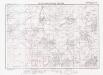
Lambert-Cholesky sheet 2573 (Vălcăul de Jos)
1 : 20000 Romanian military topographic map sheet under Lambert-Cholensky projection Institutul Geografic Militar geo-spatial.org Institutul Geografic Militar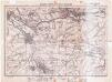
Lambert-Cholesky sheet 2574 (Șimleul Silvaniei)
1 : 20000 Romanian military topographic map sheet under Lambert-Cholensky projection Direcția Topografică Militară geo-spatial.org Direcția Topografică Militară
Lambert-Cholesky sheet 2572 (Tusa)
1 : 20000 Romanian military topographic map sheet under Lambert-Cholensky projection Institutul Geografic Militar geo-spatial.org Institutul Geografic Militar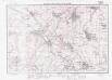
Lambert-Cholesky sheet 2675 (Dioşod)
1 : 20000 Romanian military topographic map sheet under Lambert-Cholensky projection Institutul Geografic Militar geo-spatial.org Institutul Geografic Militar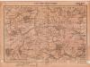
Lambert-Cholesky sheet 2775 (Jiboul Vest)
1 : 20000 Romanian military topographic map sheet under Lambert-Cholensky projection Serviciul Geografic al Armatei geo-spatial.org Serviciul Geografic al Armatei
Vermehrte und Verbesserte Landkarten des Königreichs Ungarn :
1 : 500000 Mollova mapová sbírka Stier, Martin Böner, Johann-Alexander Endter, Martin
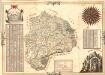
Siebenbürgen
Sedmihradsko (Rumunsko) Kipferling, Karl Joseph im Verlage des Kunst und Industrie Comptoir's
A Tisavölgy vizszabályozasi átnézeti térképe
Mapa Particvlaris Transilvaniae
Mollova mapová sbírka Geyer
Transylvaniae Principatus
1 : 720000 Mollova mapová sbírka Seutter, Matthäus Seutter, Matthäus
Nova Transilvaniae Principatus Tabula. Novissima descriptia editia
1 : 730000 Mollova mapová sbírka Ottens, Reinier Ottens, Josua
Principatus Transilvaniae
1 : 720000 Mollova mapová sbírka Homann, Johann Baptist Homann, Johann Baptista
Szegedin, Grosswardein, Ó Arad, Erlau, Szolnok
1 : 750000 Arad (Rumunsko) K. k. militär-geographisches Institut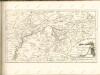

Ober Ungern
Maďarsko Ossenbrug, J. von im Verlage des Kunst und Industrie Comptoir's