Maps of Central Russian Upland
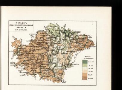
Relef srednerusskoj černozemnoj oblasti po A. Tillo
Russland Zentralrussland Relief
Raspredělenīe temperatury v janvarě i količestva osadkov zimoju v srednerusskoj černozemnoj oblasti
Russland Zentralrussland Klima Temperatur Januar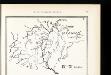
Srednerusskaja černozemnaja oblast' v IX-XIII v.v: IX-XI věka
Russland Zentralrussland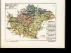
Geologičeskoe stroenīe srednerusskoj černozemnoj oblasti po kart Geol. Komiteta
Russland Zentralrussland Geologie
Karta srednerusskoj černozemnoj oblasti
Russland Zentralrussland Topografie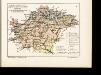
Rastitel'nyj mir srednerusskoj černozemnoj oblasti
Russland Zentralrussland Bewaldung Pflanzengeografie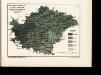
Raspredělenīe temperatury v ījulě i količestva osadkov zimoju v srednerusskoj černozemnoj oblasti
Russland Zentralrussland Klima Temperatur Juli
Krěpostnoe sostojanīe srednerusskoj černozemnoj oblasti v polovině XIX věka
Russland Zentralrussland Russland / Bauernbefreiung <1861>
Obezpečennost' sel'skago naselenīja prodovol'stv. chlěbom v srednerusskoj černozemnoj oblasti
Russland Zentralrussland Landwirtschaft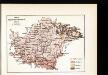
Plemena srednerusskoj černozemnoj oblasti
Russland Zentralrussland Ethnische Gruppe
Ljudnost' selenīj v srednerusskoj černozemnoj oblasti
Russland Zentralrussland Bevölkerung
Gustota naselenīja srednerusskoj černozemnoj oblasti
Russland Zentralrussland Bevölkerungsdichte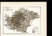
Raspachannost zemel' srednerusskoj černozemnoj oblasti
Russland Zentralrussland Bodenertrag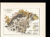
Počvy srednerusskoj černozemnoj oblasti po N. Sibircevu
Russland Zentralrussland Bodenkartierung
Srednerusskaja černozemnaja oblast' v XIV-XVII v.v: XV-XVII věka
Russland Zentralrussland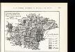
Uveličenīe količestva naselenīja s 1851 po 1897 g.g. v srednerusskoj černozemnoj oblasti
Russland Zentralrussland Bevölkerungsentwicklung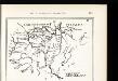
Srednerusskaja černozemnaja oblast' v XIV-XVII v.v: XIV-XV věka
Russland Zentralrussland
Zasěčnyja čerty.
Russland Krieg
Schema dviženīja lěsnoj stichīi v step v istoričeskīja vremena
Russland Zentralrussland Bewaldung Steppe Pflanzengeografie
Schema podrazdělenīj srednerusskoj i okružajuščich vozvyšennostej i nizmennostej
Russland Geografie
Srednerusskaja černozemnaja oblast' v IX-XIII v.v: XI-XIII věka
Russland Zentralrussland
Russia 6.
1 : 2217600 Letts, Son & Co.
Russia in Europe Part VI.
1 : 2100000 Society for the Diffusion of Useful Knowledge (Great Britain)

Im Stillstand von Deulino 1618 an Polen abgetretene Gebiete
1 : 8250000 Moskauer Reich Polnisch-Russischer Krieg <1609-1618>, Gebietsverlust
Des Russischen Reiches Statthalterschaften Woronesch, Belgorod Kiow o. Kleinrussland und Charkow od.
1 : 4000000 1 Karte : Kupferdruck ; 20 x 26 cm Reilly, Franz J. J. von [F. J. J. von Reilly]
Partie, Russie d'Europe. Europe 16.
1 : 1641836 Vandermaelen, Philippe, 1795-1869
[Südrussland]
1 : 1500000 Don-Gebiet, Jekaterinoslaw (Gouvernement)
Otčetnaja karta pochoda Īoanna Groznago pod Kazan' v 1552 g.
Russland Khanat Kasan Kasan Krieg Iwan IV.