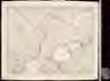
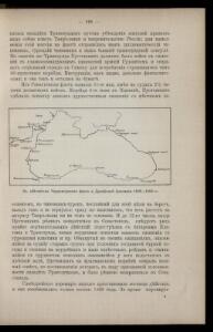
Maps of Krasnodar

K dějstvījam Černomorskago flota i Dunajskoj flotilīi 1806 - 1812 gg.
Schwarzes Meer Seeschlacht
Ice Chart Black Sea, March, April.
U.S. Navy
Ice Chart Black Sea, November, December.
U.S. Navy
Ice Chart Black Sea, January, February.
U.S. Navy
Black Sea, Index Chart for Ice Data Tables.
U.S. Navy
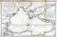
Mer Noire.
1 : 2600000 Garnier, F. A., 1803-1863
Carte de la mer noire, d'Azof et de Marmora
1 : 1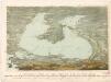
bez titulu: soubor panoramat – Krymská válka
Carte réduite de la mer noire
1 Karte : Kupferdruck ; 52 x 80 cm Bellin; Croisey s.n.
Pontus Euxinus of Niewe en naaukeurige paskaart van de Zwarte Zee
1 Karte : Kupferdruck ; 40 x 58 cm Renard; Witsen apud L. Renard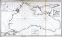
Carte réduite de la mer noire
1 Karte : Kupferdruck ; 51 x 92 cm Clerc; Dupuis Froullé
Neueste Karte der Küstenländer des Schwarzen Meeres
Grosser Hand-Atlas über alle Theile der Erde in 170 Karten Meyer, J. Verlag des Bibliographischen Instituts
Neueste Karte der Küstenländer des Schwarzen Meeres
1 : 4180000 Černé moře-oblast Radefeld, Carl Christian Franz Verlag des Bibliographischen Instituts
Neueste Karte der Küstenländer des Schwarzen Meeres
1 : 4180000 Černé moře-oblast Radefeld aus der Geograph. Graviranstalt des Bibliograph. Instituts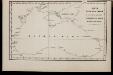
Karta Černago morja
Schwarzes Meer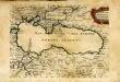
Mer noire ou mer maievre
1 Karte : Kupferdruck ; 18 x 24 cm Sanson s.n.
Mer noire ou mer maievre / par N. Sanson le fils geographe du roy
1 : 6900000 1 Karte : Kupferdruck ; 18 x 24 cm Sanson, Nicolas [chez l'Auteur]
Russia on the Euxine (Black Sea).
1 : 3380000 Sharpe, J.

Charte des Schwarzen Meeres
1 Karte : Kupferdruck ; 40 x 55 cm Götze im Verlage des Industrie Comptoirs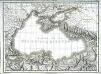
Carte de la mer noire ou Kara Degniz
1 Karte : Kupferdruck ; 30 x 42 cm Mentelle; Tardieu s.n.
Karte des Maeotischen Sees und des Pontus Euxinus
1 : 5200000 Azovské moře-oblast (Ukrajina a Rusko) Barbié du Bocage, Jean Denis Anville, Jean-Baptiste Bourguinon d'
Pontus Euxinus of Niewe en naaukeurige paskaart van de Zwarte Zee / uyt verscheydene stucken van die
1 : 2100000 1 Karte : Kupferdruck ; 40 x 58 cm Ottens, Reinier apud R. & I. Ottens
Pontos Euxeinos / ex conitabus geographicis Abrahami Ortelij
1 : 3750000 1 Karte : Kupferdruck ; 35 x 50 cm Ortelius, Abraham [Officina Plantiniana]
Nova mappa maris nigri et freti Constantinopolitani
1 Karte : Kupferdruck ; 47 x 56 cm Lotter Tobias Konrad Lotter

Carte de la Mer Noire
1 : 7420000 2 Karten auf einem Blatt : Kupferdruck ; 22 x 17 cm (13 x 17 cm und 9 x 17 cm) Bellin, Jacques Nicolas [Bellin]
Tartaria in Europe / by Robt. Morden
1 : 11100000 1 Karte : Kupferdruck ; 11 x 13 cm Morden, Robert [Printed for Robert Morden and Thomas Cockerill]
Theatre de la guerre dans la Petite Tartarie, la Crimée, la mer Noire, &c
1 Karte auf 2 Blatt : Kupferdruck ; 91 x 60 cm L'Isle chez Jean Cóvens et Corneille Mortier géographes