Maps of Balkan Pen.

Grenzen vor dem Kriege
Südosteuropa Osmanisches Reich Grenze
Grenzen Herbst 1913
Südosteuropa Osmanisches Reich Grenze Balkankrieg <1912-1913>
Die Europäische Türkei
Handatlas über alle Theile der Erde und über das Weltgebäude Stieler, Adolf Justus Perthes
Europäische Türkey
Grosser Hand-Atlas über alle Theile der Erde in 170 Karten Meyer, J. Verlag des Bibliographischen Instituts
Carte de la Turquie d'Europe
Balkánský poloostrov Boué, A. Arthus-Bertrand chez Arthus-Bertrand
Turkey in Europe.
1 : 3000000 Colton, G.W.
Die Europäische Türkei
Hand-Atlas über alle Theile der Erde und über das Weltgebäude Stieler, Adolf Justus Perthes
Generalkarte der Balkanhalbinsel
1 : 1580000 Balkánský poloostrov Handtke, Friedrich C. Flemming
Generalkarte der Balkanhalbinsel
1 : 1580000 Balkánský poloostrov Handtke, Friedrich C. Flemming
Colton's Turkey in Europe.
1 : 1600000 Colton, G.W.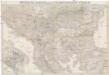
General-Karte von der europäischen Türkey
1 : 1000000 Bospor (Turecko : průliv) Kiepert, Heinrich Kratz, W. u. C. Dietrich Reimer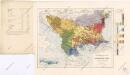
Ethnographische Karte von Europäischen Türkei...

Die Europaische Turkei.
1 : 2500000 Petermann, A.
Carte de la Turquie d'Europe
Balkánský poloostrov Boué, A. Avril, Ch. chez Arthus-Bertrand
Europ. Turkey.
1 : 3100000 Radefeld, Carl Christian Franz, 1788-1874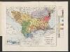
Ethnographische Karte der europäischen Türkei und ihrer Dependenzen zu Anfang des Jahres 1877
Südosteuropa Ethnische Gruppe Sax, Carl
Turkey In Europe.
1 : 3600000 Colton, G.W.
General-Karte der europäischen Türkei
1 : 1580000 Bospor (Turecko : průliv) Handtke, Friedrich C. Flemming
Das Zweite Bulgarische Reich (1087-1256 n. Chr.)
Bulgarien
Types des villages
1 : 6000000 Balkanhalbinsel Südosteuropa Ländliche Siedlung
Formes de la propriété rurale
1 : 6000000 Balkanhalbinsel Südosteuropa Grundeigentum
Types des maisons
1 : 6000000 Balkanhalbinsel Südosteuropa Haus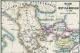
Reich des Stephan Duschan
1 : 10000000 Serbien Stefan Dušan, Srbija, Car
Turkey in Europe.
1 : 4000000 Colton, G.W.
General-Karte der europäischen Türkei und des Vladikats Montenegro
1 : 1580000 Bospor (Turecko : průliv) Handtke, J. C. Flemming
General-Karte der europäischen Türkei und des Vladikats Montenegro
1 : 1580000 Balkánský poloostrov Handtke, J. Flemming, C. C. Flemming
General-Karte der europäischen Türkei und des Vladikats Montenegro
1 : 1580000 Balkánský poloostrov Handtke, J. Flemming, C. C. Flemming
General-Karte der europäischen Türkei und des Vladikats Montenegro
1 : 1580000 Balkánský poloostrov Handtke, J. Flemming, C. C. Flemming
Karten zum russisch-türkischen Krieg 1877-1878. Europäische Türkei und Balkanstaaten nach dem Berliner Kongress
1 : 6000000 Balkanhalbinsel Russisch-Türkischer Krieg <1877-1878> , Berliner Kongress
Turecko evropské, Srbsko, Multany a Valachie, Černá Hora a pohraničné země rakouské
1 : 2300000 Evropa jihovýchodní Vaclík, Jan Wagner, Jan Eduard Jaroslav Pospíšil
Turecko evropské, Srbsko, Multany a Valachie, Černá Hora a pohraničné [sic] země rakouské
1 : 2300000 Evropa jihovýchodní Vaclík, Jan Wagner, Jan Eduard nákladem Jaroslava Pospíšila
Turecko evropské, Srbsko, Multany a Valachie, Černá Hora a pohraničné země rakouské
1 : 2500000 Evropa jihovýchodní Vaclík, Jan Wagner, Jan Eduard Jaroslav Pospíšil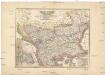
Turecko evropské
1 : 2300000 Evropa jihovýchodní Wagner, Jan Eduard Vaclík, Jan nákladem Jaroslava Pospíšila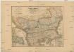
Turecko evropské, Srbsko, Multany a Valachie, Černá Hora a pohraničné [sic] země rakouské
1 : 2300000 Evropa jihovýchodní Vaclík, Jan Wagner, Jan Eduard nákladem Jaroslava Pospíšila