Maps of Bulgaria

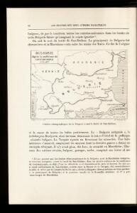
Bulgarie d'après la conférence de Constantinople 1876-1877
Bulgarien Th. Weinreb del.
Bulgarie d'après la conférence de Constantinople 1876-1877
Bulgarien Osmanisches Reich / Europäischer Teil Grenze Diplomatische Konferenz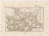
Thracia et Illyricum
1 : 1170000 Ilýrie Reichard, Christian Gottlieb Campius, D. D. Campii
Albanie Supre., Roumilie, Servie, Bulgarie, Valachie
Nouvel atlas physique politique et historique de l'Empire ottoman et des états limitrophes en Europe, en Asie et en Afrique, en quarante feuilles Hellert, J.J. Bellizard, Dufour et Cie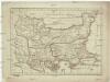
Macedonia Thracia Moesia et Illyris Graeca
1 : 2500000 Ilýrie
Paasche's Frontenkarte, Nr.6. Der Krieg gegen Russland

[Die Europäische Türkei]
Hand-Atlas über alle Theile der Erde nach dem neuesten Zustande und über das Weltgebäude Stieler, Adolf bei Justus Perthes
Der Südost-Balkan 1919-1941
Südosteuropa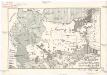
Národopisná mapa Balkánského bojiště
balkánské země Papáček, Pavel Florinskij, Timofej Dmitrijevič
Die Euopaeische Türkei von der Gränze Griechenlands bis zu den Mündungen der Donau
Hand-Atlas über alle Theile der Erde nach dem neuesten Zustande und über das Weltgebäude Stieler, Adolf bei Justus Perthes
Die europaeische Türkei von der Gränze Griechenlands bis zu den Mündungen der Donau
1 : 2500000 Evropa jihovýchodní Stülpnagel, Friedrich von Justus Perthes
Die europaeische Türkei von der Gränze Griechenlands bis zu den Mündungen der Donau
osmanská říše Stülpnagel, Friedrich von Hanemann, August Justus Perthes
Die europaeische Türkei von der Gränze Griechenlands bis zu den Mündungen der Donau
osmanská říše Stülpnagel, Friedrich von Hanemann, August Justus Perthes
Dacia, Moesia, Illyris Graeca, Macedonia et Thracia
Balkanhalbinsel, Römisches Reich, Verwaltungsgliederung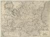
Walachia Servia, Bvlgaria, Romania
1 : 2400000 Mollova mapová sbírka Mercator, Gerhard Mercator, Gerard

Cours du Danube, de puis Belgrade jusques au Pont Evxin
1 : 2100000 Mollova mapová sbírka Sanson, Nicolas
Balkan
Balkanhalbinsel
Das Erste Bulgarische Reich (680-1018 n. Chr.)
Bulgarien
Europae tabula IX
1 : 5600000 1 Karte : Kupferdruck ; 19 x 25 cm Ptolemaeus, Claudius [Vincenzo Valgrisi]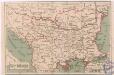
Státy Balkánské
Bulgarie d'après la conférence de Constantinople1876-1877
Bulgarien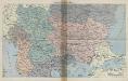
Balkan-Uebersichtskarte
1 : 2250000 Balkanhalbinsel
Südosteuropa 1878
Südosteuropa Berliner Kongress
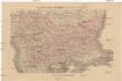
Europ. Turkey.
1 : 3100000 Radefeld, Carl Christian Franz, 1788-1874
Das Zweite Bulgarische Reich (1087-1256 n. Chr.)
Bulgarien
Die Europäische Türkei
Hand-Atlas über alle Theile der Erde und über das Weltgebäude Stieler, Adolf Justus Perthes
Bulgarien nach den Balkankriegen
Bulgarien Balkankriege Häusler, Ines
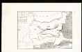
Règions occupèes par les belligèrants fin avril 1913
Südosteuropa Balkankrieg <1912-1913> Besetzte Gebiete