Maps of Pontic Steppe
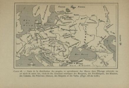
Carte de la distribution des peuples, et spécialement des Slaves, dans l’Europe orientale, au 9e siècle de notre ère, vis-à-vis des invasions asiatiques des Hongrois, des Petchénègues, des Khazars, des Cumans, des Polovtzes (Outses), des Bulgares et des Turks
Europa Slawen Bevölkerung Petschenegen
Carte de la marche envahissante des princes Varègues, de l’an 859 à l’an 930 de notre ère, avec leur sphère de rayonnement sur les peuples slaves de la Russie centrale et principalement sur le Dnieper moyen
Russland Waräger
Carte de la Slavie au 3e siècle de notre ère, lors de l’invasion des Goths et des Gépides
Ostmitteleuropa Goten Gepiden Slawen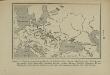
Carte des peuples slaves (Wendes ou Venèdes) établis en Europe, selon de Tacite, au 1er siècle de notre ère, savoir: Aries, Naharvalles, Roxolans, Jazyges, Lugiens, Marimes, Vénèdes, Helvécones, Elysies, Peucins. Les autres peuples indiqués sur cette carte sont germains ou finnois
Mitteleuropa Wenden Völkerwanderungszeit Tacitus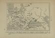
Carte de la répartition des peuples slaves, germaniques, finnois ou hunniques, au milieu du 6e siècle de notre ère, vers l’an 560
Europa Völkerwanderung Völkerwanderungszeit ethnische Gruppe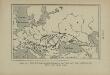
Carte de l’émigration des Sauromates, du 5e siècle au 1er siècle avant notre ère
Ostmitteleuropa Sarmaten Völkerwanderungszeit Völkerwanderung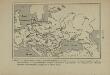
Carte du monde slave et du monde germanique à la fin du 5e siècle de notre ère, après la dispersion des Huns
Europa Slawen Germanen Bevölkerung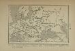
Carte de la répartition des langues slaves d’après les quatre groupes principaux de peuples slaves […]
Europa Slawische Sprachen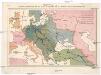
Pangermánský plán centrální Evropy - Berlín-Bagdad
Bagdád (Irák)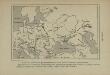
Carte des peuplements slaves au 6e siècle de notre ère, selon Jordanes
Ostmitteleuropa Slawen Bevölkerung Völkerwanderungszeit Jordanides
Tabula Europae VIII. [Karte], in: Claud. Ptolemaeus. Geographia lat. cum mappis [...], S. 275.
1 Karte aus Atlas Münster, Sebastian [und Ptolemaeus, Claudius]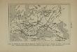
Carte du monde slave à l’époque de l’apogée de la domination mongole (an 1230 à 1450 de notre ère), et indication de la marche de l’invasion mongole d’Asie en Europe
Osteuropa Goldene Horde Mongolen
Octava Europe Tabula. [Sarmatia Europe] [Karte], in: Claudii Ptolemei viri Alexandrini mathematice discipline philosophi doctissimi geographie opus [...], S. 172.
1 Karte aus Atlas Waldseemüller, Martin [und Ptolemaeus, Claudius] Übelin, Georg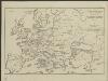
[Hierographie, oder topographisch-synchronistische Darstellung der Geschichte der christlichen Kirche] : VIII. Von Carl d. G. bis auf Gregor VII vom Jahr 800-1073
1 : 8400000 W.A. Möller Lith. bey Arnz & Co. in Düsseldorf Elberfeld : Büschler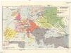
Evropa v polovině XVI. stol. (okolo r. 1560)
1 : 19350000 Evropa
Tabula Europae VIII. [Karte], in: Geographia universalis vetus et nova complectens Claudii Ptolemaei Alexandrini enarrationis libros VIII, S. 245.
1 Karte aus Atlas Münster, Sebastian [und Ptolemaeus, Claudius]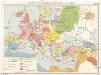
Evropa po IV. křižácké výpravě (okolo r. 1220)
1 : 19350000 Evropa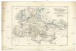
Uebersichts-Karte für die Zeit nach dem zweiten pariser Frieden
Evropa Loewenberg, Julius Herder, B.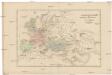
Uebersichts-Karte für die Geschichte von der Völkerwanderung bis auf Carl den Grossen
Evropa Loewenberg, Julius Herder, B.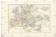
Uebersichts-Karte für das Zeitalter Napoleon's
Evropa Loewenberg, Julius Herder, B.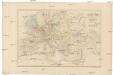
Uebersichts-Karte für die Geschichte von der Reformation bis zum westphälischen Frieden
Evropa Loewenberg, Julius Herder, B.
Uebersichts-Karte für der Carls des Grossen bis zum Ende der Kreuzzüge
Evropa Loewenberg, Julius Herder, B.
Uebersichts-Karte für die Zeit vom westphälischen Frieden bis zur französischen Revolution 1789
Evropa Loewenberg, Julius Herder, B.
Uebersichts-Karte für die Geschichte vom Ende der Kreuzzüge bis zur Reformation
Evropa Loewenberg, Julius Herder, B.
Uebersichts-Karte der nach der Völkerwanderung entstandenen neuen Reiche
Evropa Loewenberg, Julius Herder, B.
Atlas für Handel und Industrie: Für Kaufleute, Fabrikante u. Gewerbetreibende, Handlungs- u. Gewerbe-Schulen

Atlas für Handel und Industrie: Für Kaufleute, Fabrikante u. Gewerbetreibende, Handlungs- u. Gewerbe-Schulen
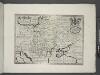
Hungary, Transylvania, Poland, &c.
from A new sett of maps both of antient and present geography : wherein not only the latitude and longitude of many places are corrected according to the latest observations, but also the most remarkable differences of antient and present geography may be quickly discern'd by a bare inspection or comparing of correspondent maps, which seems to be the most natural and easy method to lead young students (for whose use the work is principally intended) unto a competent knowledge of the geographical science : together with a geographical treatise particularly adapted to the use and design of these maps / by Edward Wells, M.A. and student of Christ-Church, Oxon.
Carte des peuplements slaves, au début du 5e siècle de notre ère, lors des invasions des Huns
Ostmitteleuropa Slawen Bevölkerung Hunnen