Maps of Mehedinti

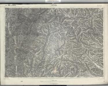
Mehadia
1 : 75000 Mehadia Geripp: Assist. Scherling. Terrain: Feuerwkr. Kotrtsch
Mehadia.; Spezialkarte der osterreichisch-ungarischen Monarchie.
from Spezialkarte der osterreichisch-ungarischen Monarchie. Austro-Hungarian Monarchy. Militärgeographisches Institut.,
Lambert-Cholesky sheet 2347 (Ada Kaleh)
1 : 20000 Romanian military topographic map sheet under Lambert-Cholensky projection Serviciul Geografic al Armatei geo-spatial.org Serviciul Geografic al Armatei
Lambert-Cholesky sheet 2549 (Comăneşti)
1 : 20000 Romanian military topographic map sheet under Lambert-Cholensky projection Direcția Topografică Militară geo-spatial.org Direcția Topografică Militară
Lambert-Cholesky sheet 2548 (Şovarna)
1 : 20000 Romanian military topographic map sheet under Lambert-Cholensky projection Direcția Topografică Militară geo-spatial.org Direcția Topografică Militară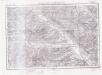
Lambert-Cholesky sheet 2547 (Crăgueşti)
1 : 20000 Romanian military topographic map sheet under Lambert-Cholensky projection Serviciul Geografic al Armatei geo-spatial.org Serviciul Geografic al Armatei
Blatt XII, [Geologisch overzicht], uit: Geologische Übersichts-Karte der Österreichisch-Ungarischen Monarchie / nach den Aufnahmen der K.K. Geologischen Reichsanstalt bearb. von Franz Ritter von Hauer ; gezeichn. von Eduard Jahn
1 : 576000 Annotatie geografische gegevens: Gebaseerd op veldwerk in de jaren 1850 tot 1865 Hauer, Franz Ritter von; Jahn, Eduard; Kaiserlich-Königliche Geologische Reichsanstalt, Wenen Wien : Beck
Oršava
1 : 200000 Oršava (Rumunsko) Kartografska radionica
Harta Cailor de Comunicatie din Judetul Mehedinti
Rumänien Judeţ Mehedinţi Verkehrsweg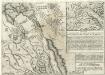
Gründliche Vorstellung der Schantz Perischan.
Mollova mapová sbírka
Orsova und Turnu-Severin.
from Spezialkarte der osterreichisch-ungarischen Monarchie.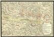
Action de Mehadia Gagne Svr les Infideles par les Trouppes Imperiales le 15. Iuillet 1738
Mollova mapová sbírka Geyer
Lambert-Cholesky sheet 2350 (Cornereva)
1 : 20000 Romanian military topographic map sheet under Lambert-Cholensky projection Direcția Topografică Militară geo-spatial.org Direcția Topografică Militară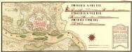
Neies Proiect von Vipalanka von Herren Obrist Lieutinant Rochet dem Hoff Krigs Rath übergeben vnd von den Selben aprobirt MDCCXI
Mollova mapová sbírka Geyer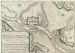
Plan nouveau tres exacte de Vipalanka
Mollova mapová sbírka
Lambert-Cholesky sheet 2550 (Baia de Aramă)
1 : 20000 Romanian military topographic map sheet under Lambert-Cholensky projection Direcția Topografică Militară geo-spatial.org Direcția Topografică Militară
Lambert-Cholesky sheet 2248 (Movila lui Scurtu)
1 : 20000 Romanian military topographic map sheet under Lambert-Cholensky projection Direcția Topografică Militară geo-spatial.org Direcția Topografică Militară
Lambert-Cholesky sheet 2249 (Iablaniţa)
1 : 20000 Romanian military topographic map sheet under Lambert-Cholensky projection Direcția Topografică Militară geo-spatial.org Direcția Topografică Militară
Lambert-Cholesky sheet 2247 (Valea Ieşelniţa)
1 : 20000 Romanian military topographic map sheet under Lambert-Cholensky projection Institutul Geografic Militar geo-spatial.org Institutul Geografic Militar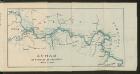
Dunav od Beograda do Radujevca
1 : 750000 Belgrad, Radujevac
Eigendliche Vorstellung des zwischen denen Key; und ein Corpo von 30000 Turken unter anführung des Seras Kiers von Widdin den 29. Jull. 1739 in dem Banat von Temeswar unweit Banzova glüklich vorbey gegangenen treffen nebst beygefugter Karten des aldortigen Terrain auf 14 Meilen
Mollova mapová sbírka
Neüe und versicherte Karten von dem Banat von Temeswar
1 : 80000 Mollova mapová sbírka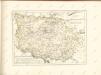

Neu Geographisch vorgestelltes Ungarisches Kriegs-Theatrum in Servien und dem Bannat Temeswar
1 : 440000 Mollova mapová sbírka Homann, Johann Baptist Homann, Johann Baptista
Tabula Bannatus Temesiensis a Geometris S.S.M.M.I.I. et R.A. confecta; quam in minorem formam reduxit, gradusque longitudinis, et latitudinis adjecit Franciscus Griselini. Augustinus Cipps sculpsit
1 : 480000 Temescher Banat Griselini, Francesco, http://d-nb.info/gnd/129735183; Cipps, Augustin, http://d-nb.info/gnd/130565644
Carte von Temescher Banat
1 : 220000 Banát Péchy von Péchyujfalu
Ober Ungern
Rumunsko Kipferling, Karl Joseph im Verlage des Kunst und Industrie Comptoir's
Ober Ungern
Rumunsko Kipferling, Karl Joseph im Verlage des Kunst und Industrie Comptoir's
Neu Geographisch vorgestelltes Ungarisches Kriegs-Theatrum in Servien und dem Bannat Temeswar. Worinnen die glückliche Progressen Kayserl. siegreichesten Waffen, unter Commando des Durchl. Princ. Eugenii von Savojen, mit allen bisher in zweyen Feldzügen 1716 und 1717 gehaltenen Schlachten und eroberten Plätzen in Kupfer gewiesen werden von Ioh. Bapt. Homann, der Röm. Kays. Maj.t Geographo in Nürnberg
1 : 450000 Serbien, Temescher Banat, Türkenkrieg <1714-1718> Homann, Johann Baptist