Maps of Sibiu

Verestorony (Rothenthurm - Pasz)
1 : 75000 Südkarpaten Pass
Lambert-Cholesky sheet 3157 (Trăineni)
1 : 20000 Romanian military topographic map sheet under Lambert-Cholensky projection Serviciul Geografic al Armatei geo-spatial.org Serviciul Geografic al Armatei
Lambert-Cholesky sheet 3257 (Cisnădie )
1 : 20000 Romanian military topographic map sheet under Lambert-Cholensky projection Direcția Topografică Militară geo-spatial.org Direcția Topografică Militară
Maršrut ot Rotenturmskago Karantina do s. Kineni
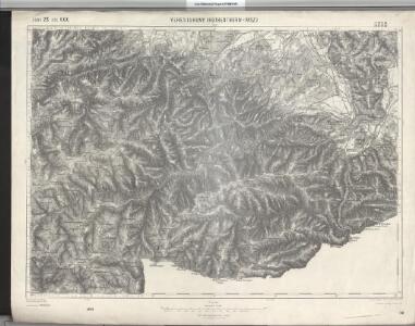
1 : 18000 Fagarašské hory (Rumunsko) Beketov, V.
Verestorony [Rothenthurm-Pasz].
from Spezialkarte der osterreichisch-ungarischen Monarchie.
Situations Plan von dem Rothenthurner Pasz oder sogennanten Carolinschen Weege
Sibiu-oblast (Rumunsko) Fáborský, Jan B. Nipočić, Vasilij
Lambert-Cholesky sheet 3356 (Vâraful Păului)
1 : 20000 Romanian military topographic map sheet under Lambert-Cholensky projection Direcția Topografică Militară geo-spatial.org Direcția Topografică Militară
Lambert-Cholesky sheet 3357 (Racoviţa)
1 : 20000 Romanian military topographic map sheet under Lambert-Cholensky projection Direcția Topografică Militară geo-spatial.org Direcția Topografică Militară
Plan sraženija pri g. Germanštatě 25 ijulja 1849 g
1 : 18000 Sibiu-oblast (Rumunsko) Beketov, V.
Lambert-Cholesky sheet 3158 (Cristian)
1 : 20000 Romanian military topographic map sheet under Lambert-Cholensky projection Direcția Topografică Militară geo-spatial.org Direcția Topografică Militară
Lambert-Cholesky sheet 3258 (Sibiu)
1 : 20000 Romanian military topographic map sheet under Lambert-Cholensky projection Direcția Topografică Militară geo-spatial.org Direcția Topografică Militară
Harta Cailor de Comunicatie din Jud. R. Valcea
Rumänien Vâlcea
Nagyszeben [Hermannstadt].
from Spezialkarte der osterreichisch-ungarischen Monarchie.
Calinesci.
from Spezialkarte der osterreichisch-ungarischen Monarchie.
Felek [Freck].
from Spezialkarte der osterreichisch-ungarischen Monarchie.
Riul Sebes.
from Spezialkarte der osterreichisch-ungarischen Monarchie.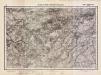
Lambert-Cholesky sheet 3057 (Vârful Strâmba Mare)
1 : 20000 Romanian military topographic map sheet under Lambert-Cholensky projection Serviciul Geografic al Armatei geo-spatial.org Serviciul Geografic al Armatei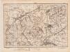
Lambert-Cholesky sheet 3358 (Avrig)
1 : 20000 Romanian military topographic map sheet under Lambert-Cholensky projection Direcția Topografică Militară geo-spatial.org Direcția Topografică Militară
Gebiet um Hermannstadt
1 : 600000 Hermannstadt, Hermannstadt (Region)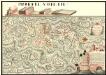
Plan der Batalie bei Beroschan in der Walachai samt den Drei Mahlichen Stvrm den 26. Jvli 1739
Mollova mapová sbírka Geyer
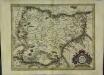
Siebenbürgen
Sedmihradsko (Rumunsko) Kunst- und Industrie Comptoir
Carte de la Roumanie et pays limitrophes. Bukarest
1 : 500000 France. Service géographique de l'armée [Paris] : Service géographique de l'armée
Sheet XV: Karte Des Oesterreichischen Kaiserstaates.
1 : 576000 Scheda, Josef
Nagyszeben (Hermannstadt), Brassó (Kronstadt), Bukarest, Craiova, Vidin, Rusčuk
1 : 750000 Brašov (Rumunsko : oblast) Korb, L. K. u. k. Militärgeographisches Institut
Hermannstadt, Kronstadt, Bukarest, Craiova, Vidin, Rusčuk
1 : 750000 Brašov (Rumunsko : oblast) K. k. militär-geographisches Institut
Generalkarte Von Siebenbürgen. Nach geometrisch gemessenen Karten und andern zuverlaessigen Hilfsmitteln verjüngt, und graduirt von Herrn A. von Wenzely. Herausgegeben von Herrn F. A. Schraembl
1 : 430000 Siebenbürgen Produkt, Straßennetz Wenzely, Anton; Schraembl, Franz Anton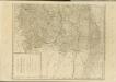

Übersichtskarte von Mittel - Europa

XV, uit: General-Karte des oesterreichischen Kaiserstaates mit einem grossen Theile der angrenzenden Länder / durch Josef Scheda ... bearb. und hrsg
1 : 576000 Annotatie geografische gegevens: Maatstokken: oesterreichische Meilen, geografische oder deutsche Meilen, preussische Meilen, türkische Berri, französische Lieues, russische Werste; Maatstok per blad: wiener Klafter, öster. Meilen; Blad XIX: statistische en taalkundige informatie; Blad XIX: legenda [Wien : K.K. Militärisch-Geografisches Institut]