Maps of Cluj
Marizel (?)
1 : 75000
19 Zóna, XXVIII Rovat, Magura, uit: [Geologische Specialkarte der im Reichsrathe vertretenen Königreiche und Länder der österreichisch-ungarischen Monarchie] / geologische Aufnahmen der königl. ung. Geologischen Anstalt
1 : 75000 Annotatie: Verantwoordelijkheidsvermelding in 1909 veranderd in: Königliche Ungarische Geologische Reichsanstalt; Sommige bladen in het Frans; Annotatie geografische gegevens: Coördinaten gebaseerd op nulmeridiaan van Ferro (Hierro) Königliche Ungarische Geologische Reichsanstalt; Königliche Ungarische Geologische Anstalt Budapest : [Königliche Ungarische Geologische Anstalt]
Lambert-Cholesky sheet 2668 (Ciurcuţa de Sus)
1 : 20000 Romanian military topographic map sheet under Lambert-Cholensky projection Serviciul Geografic al Armatei geo-spatial.org Serviciul Geografic al Armatei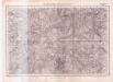
Lambert-Cholesky sheet 2667 (Petruseşti)
1 : 20000 Romanian military topographic map sheet under Lambert-Cholensky projection Serviciul Geografic al Armatei geo-spatial.org Serviciul Geografic al Armatei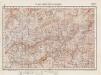
Lambert-Cholesky sheet 2768 (Mărișelu)
1 : 20000 Romanian military topographic map sheet under Lambert-Cholensky projection Institutul Geografic al Armatei geo-spatial.org Institutul Geografic al Armatei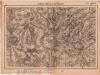
Lambert-Cholesky sheet 2767 (Cercul Dobrinului)
1 : 20000 Romanian military topographic map sheet under Lambert-Cholensky projection Serviciul Geografic al Armatei geo-spatial.org Serviciul Geografic al Armatei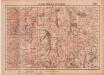
Lambert-Cholesky sheet 2669 (Mărgău)
1 : 20000 Romanian military topographic map sheet under Lambert-Cholensky projection Serviciul Geografic al Armatei geo-spatial.org Serviciul Geografic al Armatei
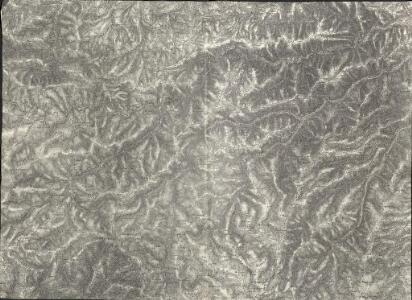
Magura.
from Spezialkarte der osterreichisch-ungarischen Monarchie.
Lambert-Cholesky sheet 2769 (Mănășturul Unguresc)
1 : 20000 Romanian military topographic map sheet under Lambert-Cholensky projection Serviciul Geografic al Armatei geo-spatial.org Serviciul Geografic al Armatei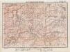
Lambert-Cholesky sheet 2868 (Muntele Rece)
1 : 20000 Romanian military topographic map sheet under Lambert-Cholensky projection Institutul Geografic Militar geo-spatial.org Institutul Geografic Militar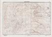
Lambert-Cholesky sheet 2867 (Muntele Băișorii)
1 : 20000 Romanian military topographic map sheet under Lambert-Cholensky projection Direcția Topografică Militară geo-spatial.org Direcția Topografică Militară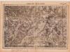
Lambert-Cholesky sheet 2766 (Vrf. Muntelui Mare)
1 : 20000 Romanian military topographic map sheet under Lambert-Cholensky projection Serviciul Geografic al Armatei geo-spatial.org Serviciul Geografic al Armatei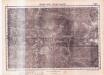
Lambert-Cholesky sheet 2666 (Albac)
1 : 20000 Romanian military topographic map sheet under Lambert-Cholensky projection Serviciul Geografic al Armatei geo-spatial.org Serviciul Geografic al Armatei
Plan sraženija pri selenii Bojlešti 14go sentjabra 1828go goda
1 : 56000
Plan sraženija pri Bojlešti 14go sentjabra 1828go goda
1 : 56000
Banffy-Hunyad (Ungarn).
from Spezialkarte der osterreichisch-ungarischen Monarchie.
Belenyes und Sulest.
from Spezialkarte der osterreichisch-ungarischen Monarchie.
Torda.
from Spezialkarte der osterreichisch-ungarischen Monarchie.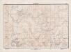
Lambert-Cholesky sheet 2567 (Scărişoara)
1 : 20000 Romanian military topographic map sheet under Lambert-Cholensky projection Direcția Topografică Militară geo-spatial.org Direcția Topografică Militară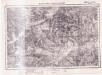
Lambert-Cholesky sheet 2568 (D. Briţiei (Bihor))
1 : 20000 Romanian military topographic map sheet under Lambert-Cholensky projection Serviciul Geografic al Armatei geo-spatial.org Serviciul Geografic al Armatei
Lambert-Cholesky sheet 2869 (Gilău)
1 : 20000 Romanian military topographic map sheet under Lambert-Cholensky projection Direcția Topografică Militară geo-spatial.org Direcția Topografică Militară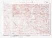
Lambert-Cholesky sheet 2569 (Vrf. Vlădeasa)
1 : 20000 Romanian military topographic map sheet under Lambert-Cholensky projection Serviciul Geografic al Armatei geo-spatial.org Serviciul Geografic al Armatei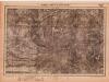
Lambert-Cholesky sheet 2866 (Runc)
1 : 20000 Romanian military topographic map sheet under Lambert-Cholensky projection Serviciul Geografic al Armatei geo-spatial.org Serviciul Geografic al Armatei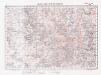
Lambert-Cholesky sheet 2566 (Gârda de Sus)
1 : 20000 Romanian military topographic map sheet under Lambert-Cholensky projection Serviciul Geografic al Armatei geo-spatial.org Serviciul Geografic al Armatei
Vermehrte und Verbesserte Landkarten des Königreichs Ungarn :
1 : 500000 Mollova mapová sbírka Stier, Martin Böner, Johann-Alexander Endter, Martin
Siebenbürgen
Sedmihradsko (Rumunsko) Kipferling, Karl Joseph im Verlage des Kunst und Industrie Comptoir's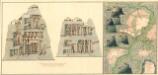
Plan dern Bergwerg bei Carlburg und Vardia
Mollova mapová sbírka Geyer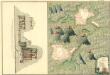
Plan von Bergwerg Pestian und Ivota
Mollova mapová sbírka Geyer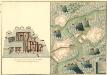
Plan der Bergwerg, Flod, Gilamare und Giogy
Mollova mapová sbírka Geyer