Maps of Vaud
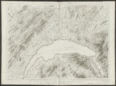
Plus grande partie de la Suisse romande ou canton du Léman
1 : 108000 Weiss, Johann Heinrich ; Guérin, Christophe ; Meyer, Johann Rudolf J. R. Meyer
Atlas Suisse
1 : 120000 16 Karten levé et dessiné par J.H. Weiss [et Joachim Eugen Müller] aux frais de J.R. Meyer à Aarau dans les années 1786 à 1802 ; gravée [sic] par [Christophe] Guérin, [Matthias Gottfried] Eichler et [Johann Jakob] Scheurmann [Johann Rudolf Meyer], Aarau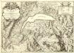
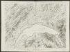
Carte du Lac de Geneve et des Pays Circonvoisins
1 : 150000 Mollova mapová sbírka Chopy, Antoine Daudet, Jean-Louis Chopy, Antoine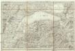
Carte du Lac de Geneve et de ses environs
1 : 320000 Ženeva (Švýcarsko : kanton)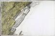
[Nozeroy - les Rousses]
1 Blatt : 59 x 90 cm s.n.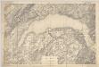
Lac Léman : carte au 1:100.000e : report sur pierre d'une partie des feuilles XI, XII, XVI, XVII de la Carte Dufour
1 : 100000 [S.l. : Bureau topographique fédéral]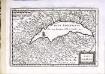
Lac Leman
1 Karte : Kupferdruck ; 13 x 19 cm s.n.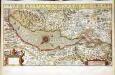
Chorographica tabula lacus Lemanni locorumqve circumiacentium
1 Karte : Kupferdruck ; 29 x 54 cm Mercator; Hondius; Goulart Henricus Hondius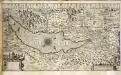
Chorographica tabula lacus Lemanni locorumqve circumiacentium
1 Karte : Kupferdruck ; 29 x 54 cm Mercator; Hondius; Goulart Jodocus Hondius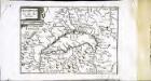
Description du lac de Geneue
1 Karte : Kupferdruck ; 11 x 15 cm Sebastian Cramoisy
Lacus Lemanni Locorumque Circumiacentium Accuratissima Descriptio. [Karte], in: Gerardi Mercatoris et I. Hondii Newer Atlas, oder, Grosses Weltbuch, Bd. 2, S. 149.
1 Karte aus Atlas Mercator, Gerhard und Hondius, Jodocus Jansson, Jan
Lacvs Lemanni Locorvmqve Circvmiacentivm Accvratissima descriptio
1 : 160000 Mollova mapová sbírka Goulart, Jacques Schenk, Peter I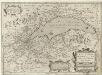
Lacvs Lemani Vicinorvmq. Locorvm Nova et Accvrata descriptio
1 : 180000 Mollova mapová sbírka Picart, Hugues Le Clerc, Jean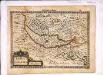
Lacus Lemannus
1 Karte : Kupferdruck ; 17 x 24 cm Mercator Cloppenburgh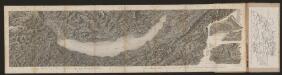
[Malerisches Relief der Schweizer- und angränzenden Alpen]
Delkeskamp, Friedrich Wilhelm F.W. Delkeskamp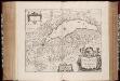
Lacvs Lemanni locorvmqve circvmiacentivm accvratissima descriptio / auctore Iacobo Govlartio Genevensi
1 : 135000 Annotatie: In cartouche: Benevole lector, F. Franciam G. Genevam denotat; Origineel is Blad 118 in atlas factice; Annotatie geografische gegevens: Drie schaalstokken op de kaart: Scala milliarium Germanicorum, Scala milliarium Sabaudicorum, en: Scala milliarium Gallicorum Jacques Goulart 1580-; Johannes Janssonius 1588-1664 Amstelodami : apud Ioannem Ianßonium
Lacvs Lemani Vicinorvmq. Locorvm Nova Et Accvrata Descriptio
1 : 180000 Mollova mapová sbírka Hondius, Jodocus Hondius, Jodocus II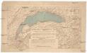
Compagnie Générale de Navigation sur le lac Léman
Labarthe, E. Compagnie générale de navigation sur le lac Léman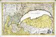
Dvcatvs Chablasivs et lacvs Lemanvs
1 Karte : Kupferdruck ; 36 x 58 cm Blaeu; Borgonio; Broen; Ottens; Ottens invenitur apud R. et I. Ottens geographos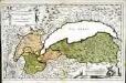
Dvcatvs Chablasivs et lacvs Lemanvs
1 Karte : Kupferdruck ; 36 x 58 cm Blaeu; Borgonio; Broen Joannes Blaeu excudit
Topographische Karte der Schweiz
1 : 100000 25 Karten vermessen und hrsg. auf Befehl der Eidgenössischen Behörden ; aufgenommen unter der Aufsicht des Generals G.H. Dufour Eidg. Topographisches Bureau, [Genève], [später: Bern]
Genève, Lausanne
1 : 100000 1 Karte par Aug. Jaccard [Wurster & Randegger], [Winterthur]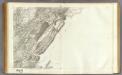
147 Nozeroy, Les Rousses.
1 : 86400 Cassini family; Cassini, Cesar-Francois, 1714-1784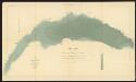
Lac Léman
1 : 50000 Hörnlimann, J. ; Lochmann, Jean Jacques ; Magnin, J. Ministère des Travaux Publics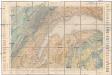
Carte géologique de la Suisse
1 : 100000 Lausanne (Švýcarsko) Schardt, H. Lugeon, M.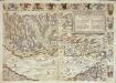
Inclitae Bernatum urbis, cum omni ditionis suae agro et provinciis delineatio chorographica, 5/6
2 Blätter : Adelbert Saueracher
Vero dissegno del lago di Geneva con i lvoghi chel circondano
1 : 200000 Bertelli, Luca Franco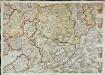
Inclitae Bernatum urbis, cum omni ditionis suae agro et provinciis delineatio chorographica, 11/12
2 Blätter : Adelbert Saueracher
Geneve, Lausanne
1 : 100000 Lausanne (Švýcarsko)