Maps of Polynesia
Atlas über die Entwicklung von Industrie und Handel der Schweiz in dem Zeitraume vom Jahr 1770 bis zum Jahr 1870
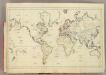
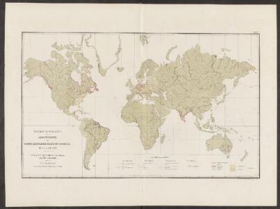
1 : 500000 Absatzgebiete des Schweizerischen Ausfuhrhandels 1820 Wartmann, Hermann Wurster Randegger & Co.
Atlas über die Entwicklung von Industrie und Handel der Schweiz in dem Zeitraume vom Jahr 1770 bis zum Jahr 1870
1 : 500000 Orientierungsblatt Absatzgebiete Wartmann, Hermann Wurster Randegger & Co.
Linien gleicher magnetischer Inklination (Isoklinen)
Atlas des Erdmagnetismus Neumayer, Georg Justus Perthes
[Verbreitungsbezirke der wichtigsten Kulturgewächse]
Zweiter Band, enthaltend in vier Abtheilungen die Vertheilung der Organismen: 5. Pflanzen-Geographie, 6. Thier-Geographie, 7. Anthropographie, 8. Ethnographie Humboldt, Alexander von Verlag von Justus Perthes
Verbreitung der Vögel I.
Atlas der Tierverbreitung Marshall, William Justus Perthes
Atlas über die Entwicklung von Industrie und Handel der Schweiz in dem Zeitraume vom Jahr 1770 bis zum Jahr 1870
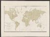
1 : 500000 Absatzgebiete des Schweizerischen Ausfuhrhandels 1770 Wartmann, Hermann Wurster Randegger & Co.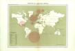
Atlas du Comité central des houilleres de France: Cartes des bassins houillers de la France, de la Grande-Bretagne, de la Belgique et de l'Allemagne

Verbreitung der Vögel II.
Atlas der Tierverbreitung Marshall, William Justus Perthes
[Terra]
země světa
Planiglob in Mercators Projection
země světa Berra, Marco bei Marco Berra
[Survey of the Geographical distribution and cultivation of the most important Plants which are used as food for man]
The physical atlas Johnston, Alexander Keith William Blackwood & Sons
Mappe monde ou carte générale du globe terrestre
země světa Robert de Vaugondy, Didier Arrivet Rue du Jardin
America
Neuester Schul-Atlas Walch, Johann im Verlag bei Joh. Walch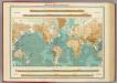
World - bathy-orographical.
1 : 83000000 John Bartholomew and Son
Navigation, les oceans.
1 : 67000000 Garnier, F. A., 1803-1863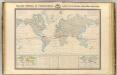
Thermometrie.
1 : 70000000 Garnier, F. A., 1803-1863
Charte über die verschiedenen jezt auf der Erde herrschenden Religionen
země světa im Verlage des Landes Industrie Comptoirs
Carte réduite d'apres celle de Laperouse
1 : 90000000 země světa La Pérouse, Jean-François de Galaup
DIE ERDE in Zwey Halbkugeln der östlichen und westlichen
země světa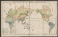
Vertheilung der wichtigsten physiologischen Pflanzengruppen in den Vegetationsgebieten der Erde
1 : 85000000 Engler, Adolf Wagner & Debes
Welt-Karte zur Übersicht der Meeres-Strömungen und des Schnellverkehrs
Hand-Atlas über alle Theile der Erde und über das Weltgebäude Stieler, Adolf Justus Perthes
Facsimile: Langsdorff's Map of the World.
1 : 92000000 Von Langsdorff, G.H.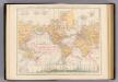
Weltverkehrs, Meeresstromungen.
1 : 90000000 Andree, Richard
Welt-Karte zur Ubersicht der Luft-Stromungen und der See-Wege.
1 : 115000000 Berghaus, Hermann
Welt-Karte zur Ubersicht der Meeres-Stromungen und des Schnellverkehrs.
1 : 115000000 Berghaus, Hermann
The World.
1 : 65000000 Letts, Son & Co.
India Extrema; XIX. Nova Tabula. [Karte], in: Claud. Ptolemaeus. Geographia lat. cum mappis [...], S. 413.
1 Karte aus Atlas Münster, Sebastian [und Ptolemaeus, Claudius]
Geographical Distribution of the Currents of Air
The physical atlas Johnston, Alexander Keith William Blackwood & Sons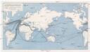
Die Weltmeere als Kriegsschauplatz
1 : 75000000 země světa Volk und Reich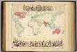
British Empire Throughout the World Exhibited In One View.
1 : 30000000 Fullarton, A. & Co.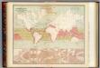
Currents of air.
1 : 70000000 Johnston, Alexander Keith, 1804-1871
Seven Puzzle Maps of the World.
Logerot
Vertheilung der Nagethiere und Wiederkauer.
1 : 130000000 Berghaus, Heinrich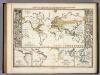
Verbreitungsbezirke Der Wichtigsten Kulturgewachse.
1 : 130000000 Berghaus, Heinrich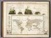
Umrisse Der Pflanzengeographie.
1 : 130000000 Berghaus, Heinrich