Maps of Switzerland
Historischer Atlas der Schweiz
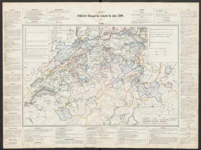
Politischer Zustand der Schweiz im Jahre 1300 Mandrot, Louis-Alphonse de Deutsche Buchhandlung von J. Kessmann
<<La>> Suisse divisée en ses treze cantons, ses alliéz & ses sujets
1 Karte par Sanson chez I Covens et C. Mortier, Amsterdam
<<La>> Suisse divisée en ses treize cantons et ses alliés
1 : 850000 1 Karte dressée par [Giovanni Antonio] Rizzi Zannoni chez Lattré, rue St Jacques, à la ville de Bordeaux, Paris
<<La>> repubblica Elvetica eve si veggono colle rispettive loro divisioni i cantoni di cui è stata composta dopo gli ultimi decreti
1 : 500000 1 Karte spatta dal sig. H.M. [i.e. Henri Mallet] ingeg.e geografo ; Gius.e Pezze inc. [Verlag nicht ermittelbar], [Erscheinungsort nicht ermittelbar]
<<La>> république helvétique ou sont distingués les cantons qui la composent suivant les derniers décrets
1 : 500000 1 Karte dressée par H.M. [i.e. Henri Mallet] ; L. Emery sc. [Verlag nicht ermittelbar], [Genève]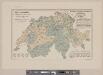
Karte der Schweiz mit Angabe der Kantons- und der Bezirksgrenzen
1 : 1050000 1 Karte vom eidg. statistischen Bureau ; Lith. Gebr. Kümmerly Eidg. statist. Bureau, [Bern]
Carte générale des trèze cantons de Suisse, Vallay, ligues Grise, Maison-Dieu & Valteline
1 : 725000 1 Karte A Paris au bout du pont neuf proche les Augustins
<<Der>> Helvetischen Republik neue Cantons und Districts Eintheilung
1 : 630000 1 Karte dem Vollziehungs-Directorium gewiedmet von Wilhelm Haas dem Sohne im Augstmonat 1798 Haas, Basel
Helvetiae, Rhaetiae & Valesiae cum omnibus finitimis regionibus tabula nova & exacta
1 : 500000 1 Karte operâ & curâ Ioh. Conradi Gygeri Tigurini delineata et excusa, anno Christi MDCXXXV [Verlag nicht ermittelbar], [Zürich]
<<Der>> Helvetischen Republik neue Cantons und Districts Eintheilung
1 : 630000 1 Karte dem Vollziehungs-Directorium gewiedmet von Wilhelm Haas dem Sohne im Augstmonat 1798 Haas, Basel
<<Die>> Helvetische Republik in Cantone und Districte eingetheilt
1 : 630000 1 Karte gedruckt bey Wilhelm Haas dem Sohne, Basel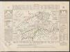
Historisch-Geographischer Atlas der Schweiz in 15 Blättern
1 : 770000 Helvetien 450 - 879 Voegelin, Johann Conrad ; Meyer von Knonau, Gerold ; Wyss, Georg von ; Meyer von Knonau, Gerold Schulthess
<<Die>> Helvetische Republik in Cantone und Districte eingetheilt
1 : 630000 1 Karte gedruckt bey Wilhelm Haas dem Sohne, Basel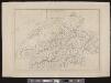
[Schweiz]
1 : 520000 1 Karte [Keller?], [Zürich?]
République helvétique divisée en ses 22 cantons
1 : 1000000 1 Karte par F.x Delamarche [chez Félix Delamarche, ingénieur-mécanicien pour les globes et sphères, rue du jardinet, no. 13], [Paris]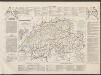
Historisch-Geographischer Atlas der Schweiz in 15 Blättern
1 : 770000 Eidgenossenschaft 1412 - 1481 Voegelin, Johann Conrad ; Meyer von Knonau, Gerold ; Wyss, Georg von ; Meyer von Knonau, Gerold Schulthess
Carte physique et politique de la Suisse
1 : 900000 1 Karte par E. Mentelle et P.G. Chanlaire an VI ; gravé par [Alexandre] Blondeau P.G. Chanlaire et E. Mentelle, Paris
Carte routière et de poste de la Suisse divisée en ses 23 cantons, comprenant les pays sujets et les pays alliés de la Suisse
1 : 530000 1 Karte dressée par [Eustache] Hérisson Basset, Paris
Karte von der Schweiz nach Faden
1 Karte neu verzeichnet herausgegeben von Franz Joh. Jos. von Reilly ; gestochen von Kil. Ponheimer zu finden im von Reilly'schen Landkarten und Kunstwerke Verschleiss Komptoir, Wien
Nova totius Helvetiae cum suis subditis ac sociis tab. geogr
1 : 1400000 1 Karte studio manu ac sumtibus Matth. Seutter ; Tob. Conr. Lotter sc. anjezo im Verlag bey Tob Conr. Lotter, Augsburg
Charte von der Schweiz nach ihrer jezigen Eintheilung
1 : 880000 1 Karte [Joseph Dirwaldt] Mollo, Wien
Helvetiae conterminarumque terrarum antiqua descriptio
1 : 2000000 1 Karte [Stich von Girolamo Porro] ; [hrsg. von Giovanni Antonio Magini] [Verlag nicht ermittelbar], [Erscheinungsort nicht ermittelbar]
Carte générale de la Suisse
1 Karte dressée en 1787 d'apres les observations les plus récentes et les plus exactes, pour servir a la nouvelle édition très augmentée du dictionnaire de la Suisse chez BMC [i.e. Barde, Manget & Compagnie], Genève
Geological map of Switzerland
1 : 800000 1 Karte by R. Leuzinger Anglo-Swiss Tourists Equipment Company, A. Ramsauer, [Erscheinungsort nicht ermittelbar]
Schweizerische Zollkarte
1 : 500000 1 Karte Schweiz. Zolldepartement = Carte douanière de la Suisse / Département Fédéral des Douanes Commissions-Verlag von Schmid u. Francke, Bern
Johnson's Switzerland
1 : 970000 1 Karte by Johnson and Ward Johnson and Ward, New York
<<Die>> Schweiz, oder, Helvetische Eidgenossenschaft
1 : 580000 1 Karte entworfen und gezeichnet von C. F. Weiland Im Verlag des Geograph. Instituts, Weimar
<<Die>> Helvetische Republik
1 : 1150000 1 Karte im Verlage des Land. Industrie Compt., Weimar
<<La>> Suisse divisée en ses treize cantons et ses alliés
1 : 850000 1 Karte projettée et assujettie aux observations astronomiques par [Rigobert] Bonne chez Lattré, rue S. Jacques, à la ville de Bordeaux, Paris