Maps of Montreux

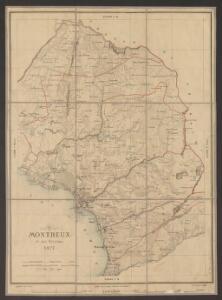
Montreux et ses environs
1 : 25000 Aubert, J. ; Krausé, Charles Etabl. lith. et topogr. H. Furrer
Topographische Karte des Kantons Freiburg: Blatt 2
1 : 50000 Stryienski, Casimir Napoléon Alexandre (1804-1875), Ingenieur, von Polen Kupferstich: Delsol, Théodore (1819-1870), von Frankreich; Hacq, J. M.; Carré. V.
Carte du gouvernement d'Aigle
1 : 65000 Rovéréa, Isaac-Gamaliel de ; Gruner, Johann Samuel ; Clausner, Jakob Joseph [s.n.]
Carte topographique du canton de Fribourg
1 : 50000 Südwest-Blatt Stryienski, Alexandre ; Delsol, Théodore ; Hacq, J.M. ; Carré, ... F. Chardon ainé
Inclitae Bernatum urbis, cum omni ditionis suae agro et provinciis delineatio chorographica, 3/4
2 Blätter : Adelbert Saueracher
Carte de la Suisse romande, 4
1 Blatt : s.n.
Carte de la Suisse romande, 4
1 Blatt : s.n.
Vevey, Sion
1 : 100000
Blatt XVII: Vevey, Sion, uit: Topographische Karte der Schweiz / vermessen und hrsg. ... unter Aufsicht des Generals G.H. Dufour
1 : 100000 Annotatie: Met plaatsnamenregister (bl. V), bladwijzer (bl. XXI) en hoogteregister (bl. XXV); Voor aanwezige bladen zie overzichtsblad Dufour, G. H. [Bern : Eidg. Topogr. Bureau]
Carte des alpes fribourgeoises
1 : 100000 1 Karte E. Wagner Josué Labastrou, Fribourg
Carte du canton de Fribourg à l'usage des écoles
1 : 100000 Stryienski, Alexandre J. Wurster et Comp.
Lac Léman : carte au 1:100.000e : report sur pierre d'une partie des feuilles XI, XII, XVI, XVII de la Carte Dufour
1 : 100000 [S.l. : Bureau topographique fédéral]
Topographische Karte der Schweiz
1 : 100000 25 Karten vermessen und hrsg. auf Befehl der Eidgenössischen Behörden ; aufgenommen unter der Aufsicht des Generals G.H. Dufour Eidg. Topographisches Bureau, [Genève], [später: Bern]
Plus grande partie de la Suisse romande ou canton du Léman
1 : 108000 Weiss, Johann Heinrich ; Guérin, Christophe ; Meyer, Johann Rudolf J. R. Meyer
Lac Leman
1 Karte : Kupferdruck ; 13 x 19 cm s.n.
Canton Freiburg sive pagus Helvetiæ Friburgensis cum confinibus
1 Karte : Kupferdruck ; 22 x 26 cm Walser Homännische Erben
Compagnie Générale de Navigation sur le lac Léman
Labarthe, E. Compagnie générale de navigation sur le lac Léman
[Malerisches Relief der Schweizer- und angränzenden Alpen]
Delkeskamp, Friedrich Wilhelm F.W. Delkeskamp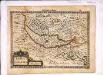
Lacus Lemannus
1 Karte : Kupferdruck ; 17 x 24 cm Mercator Cloppenburgh
Lacvs Lemanni Locorvmqve Circvmiacentivm Accvratissima descriptio
1 : 160000 Mollova mapová sbírka Goulart, Jacques Schenk, Peter I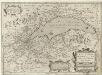
Lacvs Lemani Vicinorvmq. Locorvm Nova et Accvrata descriptio
1 : 180000 Mollova mapová sbírka Picart, Hugues Le Clerc, Jean
Carte du canton de Fribourg à l'usage des écoles
1 : 100000 1 Karte dressée en 1851 par Alexandre Stryienski d'après la grande carte topogr. du canton ; gravé par P. Steiner et R. Leuzinger J. Wurster et Comp., Winterthur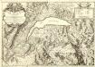
Carte du Lac de Geneve et des Pays Circonvoisins
1 : 150000 Mollova mapová sbírka Chopy, Antoine Daudet, Jean-Louis Chopy, Antoine
Taschen-Atlas der Schweiz
1 Atlas (25 S., 20 Taf.) gezeichnet und gestochen von Emil Wagner = Atlas de poche de la Suisse : 26 cartes en couleurs / dessinées et gravées par Émile Wagner Eggimann, Genf
<<Der>> Canton Freyburg
1 : 270000 1 Karte gez. u. gest. von J.J. Scheurmann [Orell Füssli], [Zürich]
Lacus Lemanni Locorumque Circumiacentium Accuratissima Descriptio. [Karte], in: Gerardi Mercatoris et I. Hondii Newer Atlas, oder, Grosses Weltbuch, Bd. 2, S. 149.
1 Karte aus Atlas Mercator, Gerhard und Hondius, Jodocus Jansson, Jan
Carte chorographique de la partie occidentale de l'Oberland ou le comté de Gruyéres divisé en quatre bailliages ou gouvernements assavoir Gruyeres, Sanen, Ober Sibenthal et Nider Sibenthal, ou se trouve le gouvernement d'Aigle et le baillaige de Vevay
1 Karte : Kupferdruck ; 54 x 71 cm Loup; Benning s.n.
<<Der>> Canton Freyburg
1 : 270000 1 Karte gez. u. gest. von J.J. Scheurmann [Orell Füssli], [Zürich]