Maps of District de la Veveyse

Carte topographique du canton de Fribourg
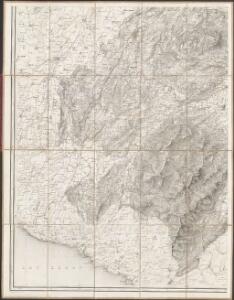
1 : 50000 Südwest-Blatt Stryienski, Alexandre ; Delsol, Théodore ; Hacq, J.M. ; Carré, ... F. Chardon ainé
Topographische Karte des Kantons Freiburg: Blatt 2
1 : 50000 Stryienski, Casimir Napoléon Alexandre (1804-1875), Ingenieur, von Polen Kupferstich: Delsol, Théodore (1819-1870), von Frankreich; Hacq, J. M.; Carré. V.
Montreux et ses environs
1 : 25000 Aubert, J. ; Krausé, Charles Etabl. lith. et topogr. H. Furrer
Carte topographique de la grande route de Berne à Genève, Blatt 7-9
3 Blätter : 35 x 48 cm Ochs
Plan des forêts communales de Bulle, Vuadens & Vaulruz
1 : 10000 Schweizerischer Forstverein Wurster, Randegger & Co.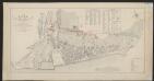
Plan de la ville de Vevey
1 : 2000 Rossier, Vincent ; Wagner, J.F. [s.n.]
Carte de la Suisse romande, 4
1 Blatt : s.n.
Carte de la Suisse romande, 4
1 Blatt : s.n.
Carte archéologique du Canton de Fribourg
1 : 100000 Bonstetten, Gustav Karl <
Der Canton Freyburg
1 : 228000 Fribourg (Švýcarsko : kanton) Scheurmann, J. J.
Atlas der Schweiz
1 : 450000 1 Atlas (18 Bl.) gez. u. gest. v. J. Scheurmann Orell Fussli, Zurich
Canton Freyburg
1 : 270000 Scheuermann, Johann Jakob [Orell Füssli]
Carte du canton de Fribourg à l'usage des écoles
1 : 100000 Stryienski, Alexandre J. Wurster et Comp.
Carte du canton de Fribourg
1 : 200000 1 Karte J.S. Gerster Wurster, Randegger & Cie., Winterthur
Canton Freiburg sive pagus Helvetiæ Friburgensis cum confinibus
1 Karte : Kupferdruck ; 22 x 26 cm Walser Homännische Erben
Carte du canton de Fribourg à l'usage des écoles
1 : 100000 1 Karte dressée en 1851 par Alexandre Stryienski d'après la grande carte topogr. du canton ; gravé par P. Steiner et R. Leuzinger J. Wurster et Comp., Winterthur
Taschen-Atlas der Schweiz
1 Atlas (25 S., 20 Taf.) gezeichnet und gestochen von Emil Wagner = Atlas de poche de la Suisse : 26 cartes en couleurs / dessinées et gravées par Émile Wagner Eggimann, Genf
<<Der>> Canton Freyburg
1 : 270000 1 Karte gez. u. gest. von J.J. Scheurmann [Orell Füssli], [Zürich]
Carte chorographique de la partie occidentale de l'Oberland ou le comté de Gruyéres divisé en quatre bailliages ou gouvernements assavoir Gruyeres, Sanen, Ober Sibenthal et Nider Sibenthal, ou se trouve le gouvernement d'Aigle et le baillaige de Vevay
1 Karte : Kupferdruck ; 54 x 71 cm Loup; Benning s.n.
<<Der>> Canton Freyburg
1 : 270000 1 Karte gez. u. gest. von J.J. Scheurmann [Orell Füssli], [Zürich]
Plus grande partie de la Suisse romande ou canton du Léman
1 : 108000 Weiss, Johann Heinrich ; Guérin, Christophe ; Meyer, Johann Rudolf J. R. Meyer
<<Der>> Canton Freyburg
1 : 270000 1 Karte gez. u. gest. von J.J. Scheurmann [Orell Füssli], [Zürich]
Carte de la partie occidentale de l'Oberland au canton de Berne
1 Karte : Kupferdruck ; 31 x 43 cm Clermont; Loup; Perrier; Beauvais; Arrivet Lamy
Atlas Suisse
1 : 120000 16 Karten levé et dessiné par J.H. Weiss [et Joachim Eugen Müller] aux frais de J.R. Meyer à Aarau dans les années 1786 à 1802 ; gravée [sic] par [Christophe] Guérin, [Matthias Gottfried] Eichler et [Johann Jakob] Scheurmann [Johann Rudolf Meyer], Aarau
<<Der>> Canton Freyburg
1 : 270000 1 Karte gez. u. gest. von J.J. Scheurmann [Orell Füssli & Comp.], [Zürich]
Atlas novus Reipublicae Helveticae
1 Atlas ([40] Bl., 97 S.) bey Orell, Gessner und Compagnie, Zürich

Carte du canton de Vaud
1 : 200000 Reber, ... ; Zwahlen, J. Barbey