Maps of Upper Savoy

Schweiz
1 : 390000 Südwest-Blatt [s.n.]
[Schweiz]
1 : 390000 Südwest-Blatt Ziegler, Jakob Melchior [s.n.]
Karte der Militärkreise
1 : 250000 1 Karte auf 4 Blättern Eidg. Stabsbüreau, [Bern]
Reisekarte der Schweiz
1 : 500000 1 Atlas (1, 6 Bl.) gezeichnet von H. Keller und gestochen von J. Scheurmann = Carte routière de la Suisse / dessinée par H. Keller et gravée par J. Scheurmann bey Fuessli und Comp., Zürich
Officielle Eisenbahn-Karte der Schweiz
1 : 250000 4 Karten gest. von H. Müllhaupt Eidg. Stabsbureau, [Bern]
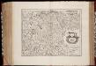
Nova Helvetiae tabula geographica illustrissimis et potentissimis cantonibus et rebuspublicis reformatae religionis Tigurinae, Bernensi, Glaronensi, Basiliensi, Scaphusianae, Abbatis Cellanae
1 : 230000 1 Karte auf 4 Bl. dominis suis clementissimis humillime dicata a Ioh. Iacobo Scheuchzero Tigurino, 1712 ; Ioh. Melch. Füsslin ornamenta pinx. ; Ioh. Henr. Huber et Eman. Schalch sculps. [Hofmeister], [Zürich]
Keller's Wandkarte der Schweiz in 8 Blättern
1 : 200000 1 Karte auf 8 Bl. dessinée et publiée par H. Keller ; auf Stein gezeichnet v. J. Heer-Grubermann ; Lith. von J. Tribelhorn Keller, Zürich
Karte der Schweiz in IV Blättern
1 : 250000 4 Karten nach dem topographischen Atlasse des eidgenössischen Generalstabes reduziert unter der Direction des Herrn Generals G.H. Dufour ; gest. von H. Müllhaupt Eidg. Stabsbureau, [Bern]
Karte der Schweiz
1 : 250000 1 Karte auf 4 Bl. [Verlag nicht ermittelbar], [Erscheinungsort nicht ermittelbar]
Officielle Eisenbahn-Karte der Schweiz
1 : 250000 4 Karten gest. v. H. Müllhaupt Eidg. Stabsbureau, [Bern]
Carte du phénomène erratique et des anciens glaciers du versant nord des Alpes suisses et de la chaîns du Mont-Blanc
1 : 250000 1 Karte auf 4 Blättern par Alphonse Favre ; publ. par la Commission géologique de la Société Helvétique des Sciences Naturelles [Verlag nicht ermittelbar], [Erscheinungsort nicht ermittelbar]
[Reisekarte der Schweiz]
1 : 500000 1 Karte auf 6 Bl. gezeichnet v. H. Keller ; gest. v. J.J. Scheurmann [Füssli & Comp.], [Zürich]
[Distanzenkarte der Schweiz]
1 : 250000 4 Karten nach dem topographischen Atlasse des Eidgenössischen Generalstabes reduziert unter der Direction des Generals G. H. Dufour ; gest. von H. Müllhaupt Eidg. Stabsbureau, Bern
Karte der Schweiz in IV Blättern
1 : 250000 4 Karten nach dem topographischen Atlasse des eidgenössischen Generalstabes reduziert unter der Direction des Herrn Generals G.H. Dufour ; gest. von H. Müllhaupt Eidg. Stabsbureau, [Bern]
[Distanzenkarte der Schweiz]
1 : 250000 1 Karte auf 4 Bl. [nach dem topographischen Atlasse des Eidgenössischen Generalstabes reduziert unter der Direction des Generals G. H. Dufour] Eidg. topogr. Bureau, [Bern]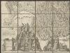
Nova Helvetiae tabula geographica illustrissimis et potentissimis cantonibus et rebuspublicis reformatae religionis Tigurinae, Bernensi, Glaronensi, Basiliensi, Scaphusianae, Abbatis Cellanae
1 : 230000 1 Karte auf 4 Bl. dominis suis clementissimis humillime dicata a Ioh. Iacobo Scheuchzero Tigurino ; Ioh. Melch. Füsslin ornamenta pinx. ; Ioh. Henr. Huber et Eman. Schalch sculps. [Hofmeister], [Zürich]
Postkarte der schweizerischen Eidgenossenschaft
1 : 300000 1 Karte in 4 Teilen unter Aufsicht des General Dufour nach den gegenwürtig vorhandenen Materialien des eidgenössischen Atlasses und den besten Karten gezeichnet von J.R. Stengel u. E. Mohr Wurster, Winterthur
Nova Helvetiae tabula geographica illustrissimis et potentissimis cantonibus et rebuspublicis reformatae religionis Tigurinae, Bernensi, Glaronensi, Basiliensi, Scaphusianae, Abbatis Cellanae
1 : 230000 1 Karte auf 4 Bl. dominis suis clementissimis humillime dicata a Ioh. Iacobo Scheuchzero Tigurino ; Ioh. Melch. Füsslin ornamenta pinx. ; Ioh. Henr. Huber et Eman. Schalch sculps. [Hofmeister], [Zürich]
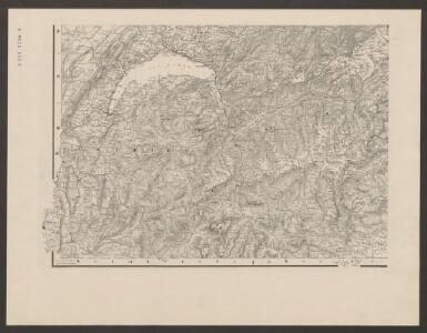
Hypsometrische Karte der Schweiz
1 : 380000 1 Karte auf 4 Blättern von J.M. Ziegler = Carte hypsométrique de la Suisse / par J.M. Ziegler Verlag von Joh. Wurster u. Comp., Winterthur
Neue Schweizerkarte von 1847
1 : 300000 1 Karte auf 4 Bl. als Wand- und Reliefkarte topisch und politisch dargestellt von Eduard Winckelmann Tobias Dannheimer, Kempten
Carte géologique de la Suisse
1 : 380000 1 Karte auf 4 Bl. par B. Studer et A. Escher de la Linth d'après leurs propres observations et les communications de leurs amis propriété de l'Etablissement topographique de J. Wurster & Comp., Winterthur
Nova Helvetiae tabula geographica
1 : 1000000 Südwest-Blatt Scheuchzer, Johann Jakob ; Schenck, Peter ex officina Petri Schenckii
Officielle Eisenbahn-Karte der Schweiz
1 : 250000 Südwest-Blatt [s.n.]
Officielle Eisenbahn-Karte der Schweiz
1 : 250000 Südwest-Blatt Müllhaupt, Hans Heinrich [Eidg. Stabsbureau]
<<Les>> Suisses, leurs alliés et leurs sujets
1 : 230000 1 Karte auf 4 Bl. par Iaillot chez l'auteur joignant les Grands Augustins aux deux Globes, Paris
Carte du phénomène erratique et des anciens glaciers du versant nord des Alpes Suisses et de la chaîne du Mont-Blanc
1 : 250000 Südwest-Blatt Favre, Alphonse Imp. par l'Etabl. topogr. de Wurster, Randegger et Cie.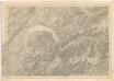
Karte der Schweiz... Blatt III.

[Keller's Reisekarte der Schweiz]
1 : 500000 1 Karte auf 6 Bl. gezeichnet v. H. Keller ; gest. v. J.J. Scheurmann [Keller], Zürich
Postkarte der schweizerischen Eidgenossenschaft
1 : 300000 Südwest-Blatt Dufour, Guillaume Henri ; Stengel, Johann Rudolf ; Mohr, Ernst Rudolf Wurster