Maps of Schattdorf
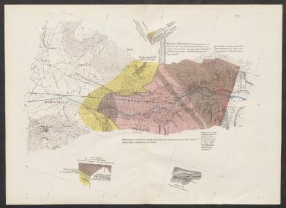
Geologische Uebersichtskarte der Gotthardbahnstrecke
1 : 25000 Blatt 1 Stapff, Friedrich Moritz [s.n.]
Altdorf
1 : 3100 [s.n.]
Gotthardbahnstrecke Erstfeld-Castione; geologische Übersichtskarten: Blatt I: Gebiet Erstfeld
1 : 25000 Auftraggebung: Direktion der Gotthardbahn Stapff, F. M., einst Vorstand der geologisch-montanistischen Abteilung bei der Zentralbauleitung der Gotthardbahn Berliner lithogr. Institut, Berlin Druck: J. F. Starke, Berlin
Relief pittoresque du sol classique de la Suisse
9 Karten dessiné d'après nature et gravé à l'eau forte par Frédéric Guillaume Delkeskamp ; terminé à l'aqua tinta par François Hegi et J.J. Sperli à Zuric = Malerisches Relief des klassischen Bodens der Schweiz / Nach der Natur gezeichnet und radirt von Friedrich Wilhelm Delkeskamp ; in Aqua tinta vollendet von Franz Hegi und J.J. Sperli in Zürich Friedrich Wilhelm Delkeskamp, Frankfurt a/M.
Karte eines Theiles von Unterwalden und Uri
Leuzinger, Rudolf R. Leuzinger
Rigi und Urner See
Geologischer Atlas zur Naturgeschichte der Erde Leonhard, Carl Cäsar von E. Schweizerbart'sche Verlagsbuchhandlung
Karte vom Vierwaldstätter See
1 : 100000 1 Karte Wurster, Winterthur
Excursions-Karte des Schweizer Alpen-Club für den Sommer 1863
1 : 100000 [s.n.]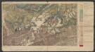
Tödi-Windgällen-Gruppe
1 : 100000 Heim, Albert Wurster & Randegger & Cie.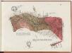
Gotthardbahnstrecke Erstfeld-Castione; geologische Übersichtskarten: Blatt II: Gebiet Silenen-Gurtnellen
1 : 25000 Auftraggebung: Direktion der Gotthardbahn Stapff, F. M., einst Vorstand der geologisch-montanistischen Abteilung bei der Zentralbauleitung der Gotthardbahn Berliner lithogr. Institut, Berlin Druck: J. F. Starke, Berlin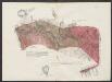
Geologische Uebersichtskarte der Gotthardbahnstrecke
1 : 25000 Blatt 2 Stapff, Friedrich Moritz [s.n.]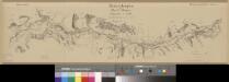
Übersichtsplan der Nord-Rampe
1 : 25000 1 Karte Baugesellschaft Flüelen-Göschenen Hofer, Zürich
[Urner See]
1 : 35000 1 Vogelschaukarte [Johann Jakob Scheuchzer] [in der Bodmerischen Truckerey], [Zürich]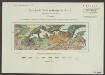
Geologische Karte der Windgällen-Kette
1 : 50000 Schmidt, Carl Wurster, Randegger & Co.
Canton Uri sive Pagus Helvetiae Uriensis cum subditis suis in Valle Lepontina recenter delineatus
1 : 60000 Mollova mapová sbírka Walser, Gabriel Dorn, Sebastian Homann, Johann Baptista - dědici
Pagus Helvetiae Uriensis Cum subditis suis in Valle Lepontina accuratissima
1 : 50000 Mollova mapová sbírka Walser, Gabriel Lotter, Tobias Conrad Seutter, Matthäus
Special-Karte vom Vierwaldstätter See und seinen Umgebungen
1 : 100000 Luzern (Švýcarsko : oblast) Dufour, Henri Guillaume C.F. Prell
Pagus helvetiæ Uriensis cum subditis suis in Valle Lepontina accuratissima delineatio
1 Karte : Kupferdruck ; 56 x 48 cm Walser; Seutter; Lotter Matthäus Seutter
Relief pittoresque du sol classique de la Suisse
9 Karten dessiné d'après nature et gravé à l'eau forte par Frédéric Guillaume Delkeskamp ; terminé à l'aqua tinta par François Hegi et J.J. Sperli à Zuric = Malerisches Relief des klassischen Bodens der Schweiz / Nach der Natur gezeichnet und radirt von Friedrich Wilhelm Delkeskamp ; in Aqua tinta vollendet von Franz Hegi und J.J. Sperli in Zürich Friedrich Wilhelm Delkeskamp, Frankfurt a/M.
Karte des Vierwaldstättersees
1 Vogelschaukarte J. Weber = Lac des IV Cantons = Map of the lake of Lucerne Orell Füssli, Zürich
Pagus Helvetiae Uriensis cum subditis suis in valle Lepontina accuratissima delineatio
1 : 116800 Seutter, Matthäus Lotter, Tobias Conrad sumptibus Matthaei Seutteri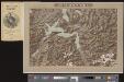
Vierwaldstättersee
1 Vogelschaukarte Orell Füssli, Zürich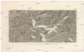
Der Vierwaldstätter See und gröster Theil der Ur-Kantone, Uri, Schwiz, Unterwalden, Luzern und Zug
Luzern (Švýcarsko : kanton) Delkeskamp, F. W. Dauch, J. Ph.
Karte der Terrassen u. Thalstufen des Reussgebietes
1 : 100000 1 Karte von Albert Heim ; [Kartogr.:] Topogr. Anstalt v. Wurster, Randegger & Co. [Verlag der Expedition des Jahrbuches des S.A.C.], [Bern]
Canton Uri sive pagus Helvetiae Uriensis cum subditis suis in Valle Lepontina
1 Karte : Kupferdruck ; 45 x 54 cm Walser; Dorn edentibus Homannianis Heredibus
Canton Uri sive pagus Helvetiae Uriensis cum subditis suis in Valle Lepontina
1 Karte : Kupferdruck ; 45 x 54 cm Walser; Dorn edentibus Homannianis Heredibus
<<Die>> Cantone Schwyz und Zug
1 : 180000 1 Karte gest. von J. Scheurmann Orell Füssli & Cp., Zürich