Maps of Metz

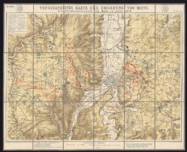
Die Kriegsoperationen um Metz im Jahr 1870
1 : 50000 Algermissen, Johann Ludwig [s.n.]
Schlacht bei Colombey-Nouilly
1 : 25000 Mety (Francie)
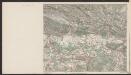
[Meurthe-et-Moselle et environ]
1 : 25000 Meurthe-et-Moselle (Francie)
[Mars-la-Tour, Vionville, Rezonville]
1 : 25000 Mars-la-Tour (Francie)
Meßtischblatt 6903 : Verny, 1882
1 : 250000 Verny. - Aufn. 1880. - 1:25000. - [Berlin]: Reichsamt für Landesaufnahme, 1882. - 1 Kt.
Meßtischblatt 6903 : Verny, 1876
1 : 250000 Verny. - Aufn. 1857. - 1:25000. - [Berlin]: Reichsamt für Landesaufnahme, 1876. - 1 Kt.
Meßtischblatt 3562 : Ars an der Mosel, 1916
1 : 250000 Ars an der Mosel. - Aufn. 1880, hrsg. 1882, Aufldr. 1916. - 1:25000. - [Berlin]: Kgl. Preuss. Landesaufnahme, 1916. - 1 Kt.
Meßtischblatt 3562 : Ars an der Mosel, 1908
1 : 250000 Ars an der Mosel. - Aufn. 1880, hrsg. 1882, bericht. 1908. - 1:25000. - [Berlin]: Reichsamt für Landesaufnahme, 1908. - 1 Kt.
Meßtischblatt 6902 : Ars (An der Mosel), 1882
1 : 250000 Ars (An der Mosel). - Aufn. 1880. - 1:25000. - [Berlin]: Reichsamt für Landesaufnahme, 1882. - 1 Kt.
Meßtischblatt 3551 : Gravelotte, 1901
1 : 250000 Gravelotte. - Aufn. 1880, hrsg. 1882, einz. Nachtr. 1901. - 1:25000. - [Berlin]: Reichsamt für Landesaufnahme, 1901. - 1 Kt.
[St. Marie aux Chénes, St. Privat, Verneville, Gravelotte, Rezonville]
Gravelotte (Francie)
Meßtischblatt 6901 : Gorze, 1882
1 : 250000 Gorze. - Aufn. 1880, hrsg. 1882. - 1:25000. - [Berlin]: Reichsamt für Landesaufnahme, 1882. - 1 Kt.
Meßtischblatt 3543 : Großmövern, 1916
1 : 250000 Großmövern. - Aufn. 1880, hrsg. 1882, B 06, Aufldr. 1916. - 1:25000. - [Berlin]: Reichsamt für Landesaufnahme, 1916. - 1 Kt.
Meßtischblatt 3544 : Lüttingen, 1916
1 : 250000 Lüttingen. - Aufn. 1880, hrsg. 1882, B 06, Aufldr. 1916. - 1:25000. - [Berlin]: Reichsamt für Landesaufnahme, 1916. - 1 Kt.
[Gravelotte, Rózerieulles]
Gravelotte (Francie)
[St. Marie aux Chénes, St. Privat]
Gravelotte (Francie)
[Tronville]
Mars-la-Tour (Francie)
[Vionville]
Vionville (Francie)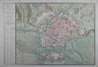
Nouveau plan de la ville de Metz
Dezauche et Bouache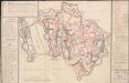
A colored "plan de l'interieur de la ville de Metz
A colored manuscript plan de l'intérieur de la ville de Metz, France, qui sert à faire connoitre, par un lavis bleu, généralement tous les bastimens royaux, militaires et civils, les différentes rues, places et débouchés nouveaux, que l'on y a faits pour le service du roy, l'utilité publique, et son embellissement, par les ordres et les soins de Monseigneur le Maréchal Duc de Belleisle, depuis l'année 1727 et 1728 jusqu'à present, 1760"; drawn on a scale of 44 toises to an inch." The plan is accompanied, [CR] LXVII.80.2.d.-g., by a written Table chronologique de toutes les piéces de fortifications, bastimens militaires et civils, et autre ouvrages, qui ont esté faits à Metz depuis 1728 jusqu'à 1760," under the orders of the Maréchal de Belleisle; with three letters to the Maréchal from the engineer De Rozières, [Louis François Cartet, Marquis de la Rozière,] dated respectively, Metz, 3 July, 5 July, and 5 August, 1760; and a memoir respecting the value of this an d the two plans at [CR] LXVII.80.2.a. and 80.2.c., which were purchased by His Royal Highness [the Duke of Cumberland?] for fifty guineas."
[Mars-la-Tour, Bruville]
Mars-la-Tour (Francie)
Territorivm Metense
1 : 160000 Mollova mapová sbírka Fabert, Abraham Schenk, Peter I
Territorivm Metense
1 Karte : Kupferdruck ; 36 x 47 cm Fabert; Schenk; Valck apud G. Valk et P. Schenk
Territorivm Metense
1 Karte : Kupferdruck ; 37 x 48 cm Fabert; Blaeu; Blaeu apud Guiljelmum et Johannem Blaeuw
Nova territorii Metensis descriptio
1 Karte : Kupferdruck ; 35 x 45 cm Fabert; Hondius; Hondius excusum apud Iodocum et Henricum Hondium fratres
Territorium Metense [...] Le Pais Messin. [Karte], in: Novus atlas absolutissimus, Bd. 4, S. 88.
1 Karte aus Atlas Janssonius Offizin
Messin Nova Territorii Metensis Descriptio [Karte], in: Gerardi Mercatoris et I. Hondii Newer Atlas, oder, Grosses Weltbuch, Bd. 2, S. 44.
1 Karte aus Atlas Mercator, Gerhard und Hondius, Jodocus Jansson, Jan
Territorium Metense [...] Le Pais Messin. [Karte], in: Le théâtre du monde, ou, Nouvel atlas contenant les chartes et descriptions de tous les païs de la terre, Bd. 2, S. 69.
1 Karte aus Atlas Blaeu, Willem Janszoon und Blaeu, Joan Blaeu, Willem Janszoon