Maps of Jura

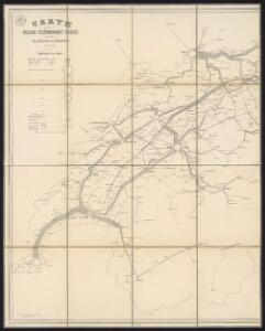
Carte du réseau téléphonique suisse
1 : 250000 Westblatt Schweizerische Telegraphen- und Telephonverwaltung H. & A. Kümmerly & Frey
Carte du réseau télégraphique Suisse
1 : 250000 Westblatt Schweizerische Telegraphen- und Telephonverwaltung Kartographische Anstalt LIPS
Carte de Suisse suivant sa nouvelle division en XVIII cantons
1 Karte in 2 Bl. dressé par H. Mallet, Ing. Geographe [Verlag nicht ermittelbar], [Erscheinungsort nicht ermittelbar]
Touristen-Karte der Schweiz
1 : 400000 Evropa Imfeld, X. Jura–Simplon-Bahn
Carte de la Suisse
1 : 400000 1 Karte auf 2 Blättern de R. Leuzinger = Karte der Schweiz : Gewässer & Gebirge / von R. Leuzinger Verlag der Dalp'schen Buchhandlung, Bern
Parte occidentale dell'Elvezia divisa ne' suoi cantoni
1 : 600000 1 Karte di nuova projezione / [G. Zuliani inc.] ; [G. Pitteri scri.] presso Antonio Zatta, Venezia
Carte de Suisse suivant sa nouvelle division en XVIII cantons formant la République Helvétique, 1
1 Blatt : chez F. Monty
Mappa Geographica illustris Helvetiorum Republicae Bernensis cum adjacentibus pagorum et dynastiarum confiniis accurate delineata
1 : 460000 Mollova mapová sbírka Seutter, Matthäus Seutter, Albrecht Carl Seutter, Matthäus
Mappa Geographica illustris Helvetiorum Republicae Bernensis cum adjacentibus pagorum et dynastiarum confiniis accurate delineata
1 : 460000 Mollova mapová sbírka Seutter, Matthäus Seutter, Albrecht Carl Seutter, Matthäus
Karte der Schweiz
Švýcarsko Leuzinger, Rudolf J. Dalp
Eisenbahnkarte der Schweiz
1 : 500000 Topogr. Anstalt v. Wurster, Randegger & Co.
Neue Karte von der Schweiz oder Helvetien in die XIII Eidgenossenschaften, ihre Bundsverwandten und Unterthanen eingetheilt
1 Karte in 2 Bl nach den zuverlässigsten Nachrichten und neuesten astronomischen Beobachtungen, London 1778 bei W. Faden [, neu hrsg. von F.A. Schraembl] Schalbacher, Wien
Telegraphenkarte der schweizerischen Eisenbahnen
1 : 400000 [s.n.]
Atlas novus Reipublicae Helveticae
1 Atlas ([40] Bl., 97 S.) bey Orell, Gessner und Compagnie, Zürich
Fragment de l'Atlas de la Suisse par Tschudi 1538
Tschudi, Aegidius Hofer & Burger
Carte generale de la Suisse suivant ses nouvelles divisions, qui conprennent les ci-devant 13 cantons, leurs alliés et sujets, et forment actuellement la republique Helvetique une et indivisible
1 : 500000 Švýcarsko Mechel, Christian von Chretien de Mechel
Carte générale de la Suisse suivant ses nouvelles divisions, qui comprennent les ci-devant XIII. cantons, leurs alliés et sujets, et forment actuellement la République Helvétique une et indivisible
1 : 510000 Švýcarsko Mechel, Christian von Chretien de Mechel
Carte generale de la Suisse suivant ses nouvelles divisions, qui comprennent les ci-devant XIII. cantons, leurs alliés et sujets, et forment actuellement la Republique Helvetique une et indivisible
Švýcarsko Mechel, Christian von Ludvík Chretien de Mechel
<<Das>> Wiflispurgergow
1 : 500000 1 Karte [von Johannes Stumpf] [Christoph Froschauer oder Johann Wolf], [Zürich]
Atlas der alten Eidgenossenschaft in 20 Karten: Kanton Bern
Originaltitel: Canton Bern sive Illustris Helvetiorum Respublica Bernensis cum Subditis suis et Confinibus. Zeichnung: Walser, Gabriel (1695-1776), reformierter Pfarrer, von Teufen AR Herausgeber: Homännische Erben
Karte des Kriegs-Schauplatzes der Schweiz
1 : 700000 2 Karten Verlag der Steiner'schen Buchhandlung, [Winterthur]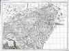
Carte pour l'histoire ancienne de l'Helvétie
1 Karte auf 4 Blatt : Kupferdruck ; 63 x 87 cm Bochat chés Bousquet
Sabavdiae, et Bvrgvndiae comitatus descriptio
1 Karte : Kupferdruck ; 30 x 21 cm Ortelius; Boileau de Bouillon s.n.
Landtaflen
1 Atlas [von Johannes Stumpf] Christoffel Froschower, Zürych
Mappa geographica illustris Helvetiorum reipublicæ Bernensis
1 Karte : Kupferdruck ; 47 x 55 cm Seutter; Lotter; Seutter Matthäus Seutter
Nouvelle carte géographique de la Suisse
1 : 600000 1 Karte auf 4 Bl. dressé par Jacq. Scheuchzer chez R. & J. Wetstein et Guil. Smith, Amsterdam
<<Das>> Wiflispurgergow
1 : 500000 1 Karte [von Johannes Stumpf] [Christoph Froschauer oder Johann Wolf], [Zürich]
Switzerland
1 : 830000 Švýcarsko Keller, Raymond Walker, J. Society for the Diffusion of Useful Knowledge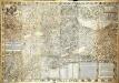
Inclitæ Bernatvm vrbis, cvm omni ditionis svæ agro et provinciis delineatio chorographica
1 Karte auf 18 Blatt : Kupferdruck ; 128 x 187 cm Schöpf; Martin; Krumm; Jobin; Saueracher; Meyer Albrecht Meyer