Maps of Bourdeau

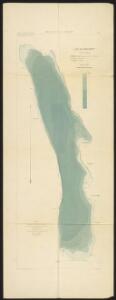
Lac du Bourget
1 : 20000 Delebecque, André ; Garcin, E. ; Magnin, J. Ministère des Travaux Publics
Carte des environs d'Aix en Savoye 1845
1 : 130000 1 Karte Stich und Druck in der topogr. Anstalt v. Joh. Wurster u. Comp. Topogr. Anstalt v. Joh. Wurster u. Comp., Winterthur
118 Belley.
1 : 86400 Cassini family; Cassini, Cesar-Francois, 1714-1784
Le Theatre de Bellone :
Mollova mapová sbírka Schenk, Pieter Braakman, Adriaan
Geneve
1 : 200000 Herder, Bartholomew
[Malerisches Relief der Schweizer- und angränzenden Alpen]
1 : 135000 11 Vogelschaukarten Nach der Natur aufgenommen und gezeichnet von F.W. Delkeskamp ; gestochen v. Knopfmacher u. J.Ph. Dauch [Friedrich Wilhelm Delkeskamp], [Frankfurt am Main]
Atlas Suisse
1 : 120000 16 Karten levé et dessiné par J.H. Weiss [et Joachim Eugen Müller] aux frais de J.R. Meyer à Aarau dans les années 1786 à 1802 ; gravée [sic] par [Christophe] Guérin, [Matthias Gottfried] Eichler et [Johann Jakob] Scheurmann [Johann Rudolf Meyer], Aarau
Carte des départements des Hautes Alpes de l'Isere, et de la Drome, no. 1
1 Blatt : s.n.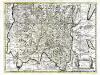
Bressia vulgo Bresse
1 Karte : Kupferdruck ; 38 x 50 cm Valck; Schenk prodeunt ex officina penes Gerardi Valk et Petri Schenk
Bresse
1 Karte : Kupferdruck ; 36 x 47 cm Janssonius Joannes Janssonius
Bresse
1 Karte : Kupferdruck ; 36 x 48 cm Hondius Henricus Hondius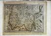
Bresse
1 Karte : Kupferdruck ; 17 x 24 cm Mercator; Keere Cloppenburgh
Carte des départements des Hautes Alpes de l'Isere, et de la Drome, no. 2
1 Blatt : s.n.
Partie meridionale des estats de Savoye
1 Karte : Kupferdruck ; 41 x 56 cm Sanson; Robert de Vaugondy chez le Sr. Robert geographe ord. du roy quai de l'Horloge du Palais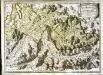
Partie meridionale des estats de Savoye
1 Karte : Kupferdruck ; 41 x 56 cm Sanson chez l'autheur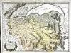
Partie septentr.nale des estats de Savoye
1 Karte : Kupferdruck ; 41 x 56 cm Sanson; Robert de Vaugondy chez le Sr. Robert geog. du roi quai de l'Horloge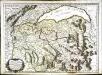
Partie septentr.nale des estats de Savoye
1 Karte : Kupferdruck ; 41 x 56 cm Sanson; Mariette chez Pierre Mariette rue St. Iacques a l'Esperance
Bressia vulgo Bresse
1 Karte : Kupferdruck ; 36 x 48 cm Blaeu Guiljelmus Blaeuw excudit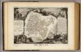
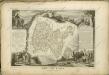
Dept. De L'Ain.
1 : 580000 Levasseur, Victor.
Département de l'Ain
1 : 260000 Ain (Francie) Houdan, François d' P. G. Chanlaire et Dumez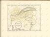

BRESSIA | Vulgo | BRESSE
Amsterdami. | Guiljelmus Blauw excudit

Duché de Savoye
1 Karte : Kupferdruck ; 47 x 50 cm Robert de Vaugondy; Borgonio s.n.
Carte itinéraire des pays de Bresse Bugey et Gex
1 Karte : Kupferdruck ; 59 x 67 cm Seguin s.n.
Bressia Vulgo Bresse [Karte], in: Novus atlas absolutissimus, Bd. 4, S. 215.
1 Karte aus Atlas Janssonius Offizin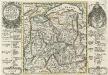
Das Hertzogthum Savoya :
1 : 1100000 Mollova mapová sbírka Bodenehr, Gabriel Bodenehr, Gabriel
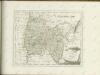
Département de l'Isere
1 : 265000 Isere (Francie) Houdan, François d' P. G. Chanlaire et Dumez