Maps of Vojvodina

Strassen- und Eisenbahnkarte des oesterreichischen Kaiserthumes
1 : 864000 Blatt 11 Schaller, G. K.K. Militärisch-Geografisches Institut, Karten-Evidenthaltungs-Abteilung
Letecká mapa Evropy

Ungarn:. Comitate: Baranya, Bács, Csanád, Temes, Torontal. Slavonien. Comit.: Sirmien, Veröcze. Militär Gränze: Brod, Petervardein, Csajkisten Kreisz, Deutschbanater Regiment
Ungarn Verkehrsweg
Die Kriegsschauplatz in Ungarn
1 : 864000 Evropa jihovýchodní K.k. Generalstabes
Die Kriegsschauplatz in Ungarn
1 : 864000 Evropa jihovýchodní K.k. Generalstabes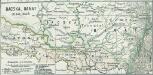
Bacska, Banat 1848, 1849
1 : 2775000 Banat, Batschka, Ungarn / Revolution <1848-1849>
Tabvla geographica exhibens regnvm Sclavoniae cum Syrmii ducatu
Slavonie (Chorvatsko) ab Homannianis Heredibus
Tabvla geographica exhibens regnvm Sclavoniae cum Syrmii ducatu
Slavonie (Chorvatsko) ab Homannianis Heredibus
Tabvla geographica exhibens regnvm Sclavoniae cum Syrmii ducatu
Slavonie (Chorvatsko) Hommanianis Heredibus
Le Royaume de Hongrie Diuise'en Haute, et Basse, Hongrie auec l'Esclavonie, Subdiuisees en leurs Comtez
1 : 1300000 Mollova mapová sbírka Coronelli, Vincenzo Maria Nolin, Jean Baptiste
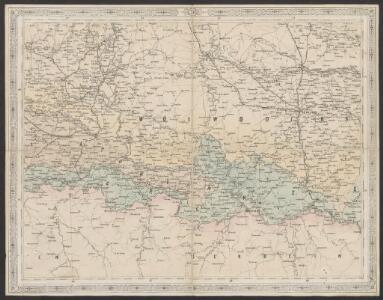
XIV, uit: General-Karte des oesterreichischen Kaiserstaates mit einem grossen Theile der angrenzenden Länder / durch Josef Scheda ... bearb. und hrsg
1 : 576000 Annotatie geografische gegevens: Maatstokken: oesterreichische Meilen, geografische oder deutsche Meilen, preussische Meilen, türkische Berri, französische Lieues, russische Werste; Maatstok per blad: wiener Klafter, öster. Meilen; Blad XIX: statistische en taalkundige informatie; Blad XIX: legenda [Wien : K.K. Militärisch-Geografisches Institut]
Sclavonia Croatia Bosnia cum Dalmatiae Parte
1 : 930000 Mollova mapová sbírka Mercator, Gerhard Mercator, Gerard
Königreich Slavonien
1 : 770000 Slavonie (Chorvatsko) Tranquillo Mollo
Koenigreich Slavonien
1 : 828000 Slavonie (Chorvatsko) Mollo, Tranquillo Tranquillo Mollo
Slawonien-Syrmien 1745-1918
Slawonien, Sirmien, Verwaltungsgliederung Zwick, J.
Slawonien-Syrmien heute
Slawonien, Sirmien, Jugoslawienkriege Zwick, J.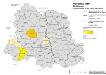
Vojvodina 1900. Ruthenen
Wojwodina ethnische Gruppe, Russinen Hofinger, Veronika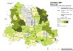
Vojvodina 1900. Deutsche
Wojwodina ethnische Gruppe, Deutsche Hofinger, Veronika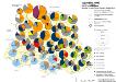
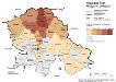
Vojvodina 1900. Nationalitäten
Wojwodina ethnische Gruppe Hofinger, Veronika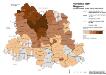
Vojvodina 1900. Magyaren
Wojwodina ethnische Gruppe, Magyaren Hofinger, Veronika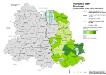
Vojvodina 1900. Rumänen
Wojwodina ethnische Gruppe, Rumänen Hofinger, Veronika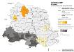
Vojvodina 1900. Kroaten
Wojwodina ethnische Gruppe, Kroaten Hofinger, Veronika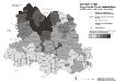
Vojvodina 1900. Ungarische Sprachkenntnisse
Wojwodina Ungarisch, Fremdsprachenkenntnis Hofinger, Veronika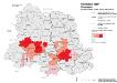
Vojvodina 1900. Slowaken
Wojwodina ethnische Gruppe, Slowaken Hofinger, Veronika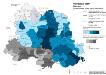
Vojvodina 1900. Serben
Wojwodina ethnische Gruppe, Serben Hofinger, Veronika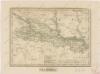
Slavonsko

Nieuwe Accurate Kaert van een gedeelte van Hongarie, en Donau Stroom Vertonnende Belgrado en Peter Wardein
1 : 410000 Mollova mapová sbírka Keulen, Gerard van Keyser, Jacob Keulen, Gerard van
Augustissimo Romanor. Imperatori Iosepho I. Hungaria Regi Invictissimo Mappam Hanc Regni Hungariae
1 : 540000 Mollova mapová sbírka Müller, Johann Christoph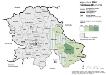
Vojvodina 1981. Rumänen (Rumuni)
Wojwodina ethnische Gruppe, Rumänen Hofinger, Veronika