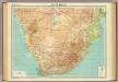
Maps of Kalahari Desert

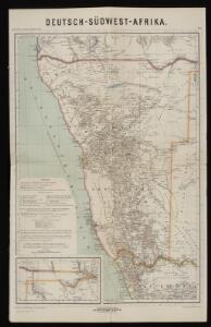
Deutsch-Südwest-Afrika
1 : 3000000 Kiepert, Richard ; Sprigade, Paul Geographische Verlagshandlung Dietrich Reimer
Deutsch-Südwestafrika
1 : 2000000 Namibie Sprigade, Paul Fischer, R. Dietrich Reimer (Ernst Vohsen)
Gross-Namaqua-Land und das Gebiet des Hauses F.A. Lüderitz
1 : 1750000 Durynsko (Německo) Hassenstein, Bruno Hahn, Th. Justus Perthes
Deutsche Kolonien
1 : 12000000 Kamerun Meyer, Joseph Bibliographisches Institut
Union of South Africa Special Map Accompanying Richmond's South African All Mining Year Book (Sheet 1)
Union of South Africa. Special map accompanying Richmond's South African All Mining Year Book illustrating the location of Mines, Quarries and Works. Johannesburg : Hortors
Cape Province, Transvaal, &c. - western section.
1 : 2500000 John Bartholomew and Son
Cote Deserte. Afrique 48.
1 : 1641836 Vandermaelen, Philippe, 1795-1869
Partie, Pays des Hottentots. Afrique 50.
1 : 1641836 Vandermaelen, Philippe, 1795-1869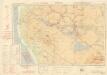
Ondangua

Carte internationale du monde au 1,000,000 E
1 : 1000000 Windhoek (Namibie) Surveyor generals office S.W. Africa
Benguela. Afrique 44.
1 : 1641836 Vandermaelen, Philippe, 1795-1869
International map 1:1,000,000
1 : 1000000 Jihoafrická republika Geographical Section, General Staff
No title

General overview of the farms in parts of the Windhoek and Karibib districts

Provincia de Angola Ponta Albina à foz do Cunene
1 : 200000 Hydrographic Map Instituto Hidrográfico Portugal Instituto Hidrográfico Portugal
Sheet Windhoek

Höhenschichten-Karte der Deflationslandschaft in der Namib Südwestafrikas und ihrer Umgebung
1 : 25000 Namibie Kaiser, Erich Verlag der Bayerischen Akademie der Wissenschaften
Provincia de Angola Baía dos Tigres Enseada do Leão
1 : 10000 Hydrographic Map Instituto Hidrográfico Portugal Instituto Hidrográfico Portugal
[Kaart], uit: Karte des Afrikander-Aufstandes im Kaplande und des Angriffskrieges der Buren / Paul Langhans
1 : 4000000 titelvariant: Karte des Afrikander-Aufstandes im Kaplande; Annotatie: Omslagtitel: Karte des Afrikander-Aufstandes im Kaplande; Met portret van Christian de Wet Langhans, Paul Gotha : Perthes
Spezial - karte von AfricaSektion Capland (9)
1 : 4000000 1 full d'1 mapa en 10 fulls i estoig Hermann Habenicht; Justus Perthes
Spezial-Karte von Afrika
1 : 4000000 Blatt 9 Habenicht, Hermann Perthes
La Basse Guinée, contenant les royaumes de Loango, de Congo, d'Angola et de Benguela, avec la Cafrérie occidentale et la méridionale, ou le pays des Hotentots
1 : 9600000 Angola Bonne, Rigobert André
[LL.04751gk: 591/od/1899] [Recto], uit: Kaart van Zuid-Afrika : (Zuid-Afrikaansche Republiek, Oranje-Vrijstaat en aangrenzend gebied)
1 : 5600000 Amsterdam [etc.] : J.H. de Bussy
Charte von Nieder Guinea
Angola
CHARTE von NIEDER GUINEA
Angola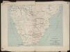
Itinéraire de Mr et Mme Coillard du Pays des Bassoutos au Zambèze
1 : 12100000 [Paris] : Société de géographie
Karte von Transvaal und der angrenzenden Gebiete
1 : 5000000 Afrika jižní Dietrich Reimer (Ernst Vohsen)
Politisch - militärische Karte von Süd-Afrika

Politisch-militärische Karte von Süd-Afrika : zur Veranschaulichung der Kämpfe zwischen Buren und Engländern bis zur Gegenwart / Paul Langhans
1 : 4000000 Langhans, Paul Gotha : Justus Perthes