Maps of Lower Saxony

Karte von Deutschland in IV Blättern
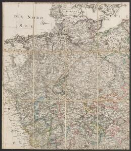
1 : 825000 Nordwest-Blatt Sotzmann, Daniel Friedrich im Verlage der A. G. Schneider und Weigels
The north west part of Germany.
1 : 2500000 Moll, Herman, d. 1732
The North West Part of Germany
1 : 2500000 Mollova mapová sbírka Moll, Herman Moll, Hermann
Germany - western section.
1 : 1000000 John Bartholomew and Son
NW pt. of Germany.
1 : 2150000 Bowen, Emanuel
Allemagne du N.O.
1 : 1500000 Vivien St Martin, L.
Nordwest-Deutschland
1 : 2000000 Německo severozápadní Kocen, Blaž E. Hölzel
Germany N. of Mayne.
1 : 1200000 Thomson, John
Eisenbahnkarte von Nordwest-Deutschland
1 : 2000000 Německo severozápadní Geograph. Anstalt von Wagner & Debes
Circulus Westphalicus in suas provincias et ditiones accurate distinctus et recentissime delineat
1 : 1000000 cura et caelo Matth. Seutteri S.C.M.G. G. Matthaeus Seüter jun. sculpsit. Aug. Vind : [Matthäus Seutter]
Northern and Central Germany.
1 : 2154240 Fullarton, A. & Co.
Germany north.
1 : 2800000 Arrowsmith, Aaron; Lewis, Samuel
Germany north.
1 : 2800000 Arrowsmith, Aaron; Lewis, Samuel
German Empire 1.
1 : 1774080 Letts, Son & Co.
CIRCULUS WESTPHALICUS IN SUAS PROVINCIAS ET DITIONES accurate distinctus et recentissime delineat
1 : 1100000 Vestfálsko (Německo) Seutter, Matthäus cura et caelo Matth. Seutteri
Circulus Westphalicus in suas provincias et dittiones
1 : 1040000 Vestfálsko (Německo) Seutter, Matthäus cura et caelo Matth. Seutteri
Circulus Westphalicus in suas provincias et dittiones
1 : 1040000 Vestfálsko (Německo) Seutter, Matthäus cura et caelo Matth. Seutteri
Königreich Westphalen samt dem Herzogthume Mecklenburg
1 : 2230000 Meklenbursko (Německo)
Germany (Deutschland)
1 : 1776000 Hannover (Německo) Walker, C. Baldwin & Cradock
[Hannover, Braunschweig, Kurhessen, Gr. Herz. Hessen, Hess. Homburg]
Schul-Atlas in 36 Karten Völter, Daniel Verlag der J.M. Dannheimer'schen Buchhandlung
Circulus Westphaliae cum omnibus suis subjacentibus provinciis novissima delineatio
1 : 1000000 1 Karte : Kupferdruck ; 49 x 56 cm Danckerts, Justus [Danckerts]
Germany.
1 : 1500000 Colton, G.W.
Germany north of the Mayn.
1 : 1180000 Pinkerton, John, 1758-1826
Circulus Westphalicus
1 : 1000000 Mollova mapová sbírka Seutter, Matthäus Seutter, Matthäus
Circulus Westphaliae cum Omnibus Suis Subjacentibus Provinciis Novissima Delineatio
1 : 1000000 Mollova mapová sbírka Ottens, Josua Ottens, Josua
Westphalen
Allgemeiner Atlas [Walch, Johannes] im Verlag bei Johannes Walch
Nordwestliches Deutschland
Neuer Handatlas über alle Theile der Erde Kiepert, Heinrich Verlag von Dietrich Reimer
[Vestfálsko a okolí]
Vestfálsko (Německo)
Germany - North. Pergamon World Atlas.
1 : 1250000 Polish Army Topography Service