Maps of Upper Bavaria

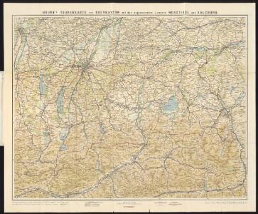
Brunn's Tourenkarte von Oberbayern mit angrenzenden Ländern Nordtirol und Salzburg
1 : 250000 Brunn
Des Herzogthums Oberbayern Pfleggerichte Landsberg, Schongau, Hohenschwangau, Wellheim, Starenberg, Wolfertshausen, Tölz, Aurburg, Aibling, Schwaben, Wasserburg, Rosenheim, Marquartstein, Traunstein und Reichenhall, oder des Rentamts München südlicher Theil mit der Grafschaft Haag und Herrschaft Hohen Waldeck
1 Karte : Kupferdruck ; 20 x 39 cm Reilly F. J. J. von Reilly
Bavariae Pars Superior tam in sua Regimina Principaliora quam in eorundem Praefecturas Particulares accuratè divisa
1 : 380000 Mollova mapová sbírka Homann, Johann Baptist Homann, Johann Baptista
Bavariae
1 : 390000 Mollova mapová sbírka Seutter, Matthäus Seutter, Matthäus
Bavariae Pars Superioror
1 : 370000 Mollova mapová sbírka Visscher, Nicolaes Visscher, Nicolaus
Sect. 27: München, uit: Geologische Karte des Deutschen Reichs in 27 Blaettern / [von] Richard Lepsius ; Red. von C. Vogel
1 : 500000 Annotatie: Blad 18 ontbreekt; Een aantal bladen op linnen; Een aantal bladen gereviseerd 1913-1914; Annotatie geografische gegevens: Met schaalstokken o.a. in kilometers; Legenda Carl Vogel 1828-1897 Gotha : Justus Perthes

Bavaria Dvcatvs
1 : 780000 Mollova mapová sbírka Merian, Matthaeus Merian, Matthäus
Salisburgensis jurisdictionis locorumque vicinorum vera descriptio
1 Karte : Kupferdruck ; 18 x 26 cm Quad; Nagel; Bussemacher; Secznagel Johannes Bussemacher
Bavariae Pars superior

Accurata delineatio episcopat[us] Frisingensis
1 Karte : Kupferdruck ; 55 x 47 cm Lotter Tobias Conrad Lotter
Accurata delineatio episcopat[us] Frisingensis
1 Karte : Kupferdruck ; 54 x 48 cm Seutter Matthäus Seutter
Accurata Delineatio Episcopat. Frisingensis
1 : 266600 Mollova mapová sbírka Seutter, Matthäus Seutter, Matthäus
Militair Karte von Süd-Deutschland in 20 Sectionen
1 : 400000 15. Section Coulon, Alois von A. von Coulon
[Fol. III]
1 Karte : 43 x 55 cm Königliche Akademie der Wissenschaften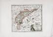
Des Herzogthums Oberbayern Pfleggerichte Neuötting, Mörmosen, Craiburg, Cling, Trosburg, Julbach und die Herrschaften Hohenaschau und Wildenwart oder das Rentamt Burghausen
1 Karte : Kupferdruck ; 22 x 26 cm Reilly F. J. J. von Reilly
Das Herzogthum Ober und Nieder Baiern, 3
1 Karte : 43 x 55 cm Lotter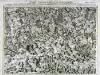
Carte topographique d'Allemagne contenant une partie de la Baviere, de l'eveché de Salzburg, de Tirol
1 Karte : Kupferdruck ; 46 x 63 cm Jaeger se vend chez l'auteur
Mappa Electoratus et Ducatus Bavariae Superioris et Inferioris, Ducatus Neoburgesis cum Episcopatibus Frisingensi Ratisbonensi Passaviensi et Praepositura Bergtolsgadensi].
1 : 260000 Mollova mapová sbírka Apian, Philipp
Tyrolis sub Felici Regimine Mariae Theresiae Rom. Imper. Avg. Chorographice Delineata ...
1 : 104000 Mollova mapová sbírka Mansfeld, Johann Ernst Mansfeld, Johann Ernest
Tyrolis sub Felici Regimine Mariae Theresiae Rom. Imper. Avg. Chorographice Delineata ...
1 : 104000 Mollova mapová sbírka Mansfeld, Johann Ernst Mansfeld, Johann Ernest
Tyrolis sub Felici Regimine Mariae Theresiae Rom. Imper. Avg. Chorographice Delineata ...
1 : 104000 Mollova mapová sbírka Mansfeld, Johann Ernst Mansfeld, Johann Ernest
Tyrolis sub Felici Regimine Mariae Theresiae Rom. Imper. Avg. Chorographice Delineata ...
1 : 104000 Mollova mapová sbírka Mansfeld, Johann Ernst Mansfeld, Johann Ernest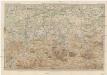
Karte der Salzburger-Alpen und des Salzkammerguts
1 : 250000 Salcburské Alpy (Rakousko : pohoří) Ravenstein, Ludwig L. Ravenstein
Gebirgs-Karte
Alpy rakouské (pohoří) in Commission der literarisch-artistischen Anstalt
Sacri Romani imperii circuli et electoratus Bavariae tabula, 5
6 Blätter : s.n.
Spezial-Karte von Salzburg, Salzkammergut und einen Theil von Tyrol
1 : 320000 Salcbursko (Rakousko) Orlitsek, Fr. Vesco, Ciprian Ciprian Vesco's sel. Witw.
Spezial-karte von Salzburg, Salzkammergut und einen Theil von Tyrol
1 : 350000 Horní Rakousko (Rakousko) Orlitsek, Fr. Tritschlen, J. Ciprian Vesco's fel. Witw.