Maps of Srubec

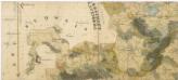
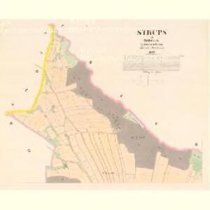
Strups - c7210-1-004 - Kaiserpflichtexemplar der Landkarten des stabilen Katasters
1 : 2880
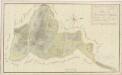
Strups - c7210-1-003 - Kaiserpflichtexemplar der Landkarten des stabilen Katasters
1 : 2880
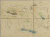
Strups - c7210-1-002 - Kaiserpflichtexemplar der Landkarten des stabilen Katasters
1 : 2880
Strups - c7210-1-001 - Kaiserpflichtexemplar der Landkarten des stabilen Katasters
1 : 2880
Trzebotowitz - c8049-1-003 - Kaiserpflichtexemplar der Landkarten des stabilen Katasters
1 : 2880
Trzebotowitz - c8049-1-004 - Kaiserpflichtexemplar der Landkarten des stabilen Katasters
1 : 2880
Trzebotowitz - c8049-1-005 - Kaiserpflichtexemplar der Landkarten des stabilen Katasters
1 : 2880
Trzebotowitz - c8049-1-006 - Kaiserpflichtexemplar der Landkarten des stabilen Katasters
1 : 2880
Trzebotowitz - c8049-1-002 - Kaiserpflichtexemplar der Landkarten des stabilen Katasters
1 : 2880
Trzebotowitz - c8049-1-001 - Kaiserpflichtexemplar der Landkarten des stabilen Katasters
1 : 2880
Srubec, berní okres České Budějovice, země Česká
1 : 2880 Srubec (Česko) Reprodukční ústav Ministerstva financí
České Ohrazení, berní okres České Budějovice, země Česká
1 : 2880 Ohrazení (Ledenice, Česko) Reprodukční ústav Ministerstva financí
Hodonice o. Tábor 1
1 : 2880
Mapa trvale změněných hranic kultur při dvoře Mysletín 1
1 : 2880
Ledenice o. České Budějovice 1
1 : 2880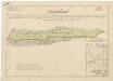
Geometrický plán pozemků obce Třebotovice a Srubec, směněných s rudolfovskými doly 1

Zborov o. České Budějovice 1
1 : 2880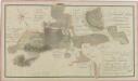
Geometrický plán dvora Zborov,zborovské myslivny, dominikálních domků a přilehlých činžovních pozemků 1
Geometrický plán dvora Mysletín se všemi přilehlými pozemky 1
Mapy činžovních pozemků IV. sekce třeboňského velkostatku pro obce: Doudleby, Hodovice, Ledenice, Miletín, Nový Dvůr, Petrovice, Štěpánovice, Zborov 1

Zalin - c9114-1-004 - Kaiserpflichtexemplar der Landkarten des stabilen Katasters
1 : 2880
Zalin - c9114-1-001 - Kaiserpflichtexemplar der Landkarten des stabilen Katasters
1 : 2880
Zalin - c9114-1-002 - Kaiserpflichtexemplar der Landkarten des stabilen Katasters
1 : 2880
Zalin - c9114-1-005 - Kaiserpflichtexemplar der Landkarten des stabilen Katasters
1 : 2880
Zalin - c9114-1-003 - Kaiserpflichtexemplar der Landkarten des stabilen Katasters
1 : 2880
Mapy činžovních pozemků IV. sekce třeboňského velkostatku pro obce: Dolní Miletín, Doubravice, Doudleby, Hodovice, Horní Miletín, Ledenice, Nový Dvůr, Petrovice, Slavošovice, Štěpánovice, Zborov 1

Mapy činžovních pozemků IV. sekce třeboňského velkostatku pro obce: Dolní Miletín, Doubravice, Doudleby, Hodovice, Horní Miletín, Ledenice, Nový Dvůr, Petrovice, Slavošovice, Štěpánovice, Zborov 1

Mapy činžovních pozemků IV. sekce třeboňského velkostatku pro obce: Doudleby, Hodovice, Ledenice, Nový Dvůr, Zborov, Zvíkov 1

Mapy činžovních pozemků IV. sekce třeboňského velkostatku pro obce: Doudleby, Hodovice, Ledenice, Nový Dvůr, Zborov, Zvíkov 1