Maps of British Isles

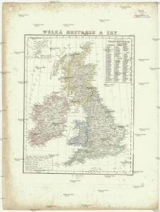
Welká Britanie a Iry
1 : 3400000 Irsko Merklas, Václav W. Merklas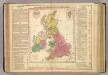
British Empire.
1 : 3200000 Lavoisne, M.

Welká Britanie a Iry

British Islands.
1 : 4000000 Schonberg & Co.
Novissima prae caeteris aliis accuratissima regnorum Angliae, Scotiae Hiberniaeq[ue] tabula
1 : 1850000 Irsko Wit, Frederick de F de Wit
British Isles.
1 : 3651000 Fisher, Richard Swainson
Stereographical map, British Isles.
1 : 1600000 Stanford, Edward
Die Britischen Inseln nach ihrer kirchlichen Eintheilung bis zur Reformation.
1 : 3000000 Spruner von Merz, Karl
British Islands.
1 : 2300000 Morse, Jedidiah; Morse, Sidney E. (Sidney Edwards), 1794-1871
Iles Britanniques.
Andriveau-Goujon, J.
Grossbritanien.
1 : 3900000 Haller von Hallerstein, Friedrich; Reichard, C. G.
Brittannicae Insule ex Aevi Romani Monumentis. (1826)
1 : 3900000 Tanner, Henry S.
Tabula novissima accuratissima regnorum Angliae, Scotiae Hiberniae
1 : 1850000 Irsko Seutter, Matthäus Mattheo Seutter
Die Britischen Inseln oder die Vereinigten Königreiche
1 : 1850000 Normanské ostrovy Kiepert, Heinrich Gräf, C. Geographisches Institut
British Isles (Political).
1 : 1900000 Johnston, W. & A.K.
Grossbritannien und Ireland
1 : 2200000 Irsko Weiland, Karl Ferdinand Maedel, Carl Jos. Geograph. Institut
Isles Britanniques.
1 : 2600000 Jouvet et Cie.
British Islands.
1 : 4700000 Grigg, John
Die Britischen Inseln seit 1485.
1 : 3000000 Spruner von Merz, Karl
Charte der vereinigten Königreiche Grossbritanien und Irland
1 : 2900000 Irsko Kipferling, Karl Joseph Kunst ind Industrie Comptoir
British Isles (outline)
1 : 4500000 Patteson, Edward
British Isles.
1 : 4500000 Patteson, Edward
Grossbritanien und Irland
Irsko Sotzmann, Daniel Friedrich Kliewer, Heinrich
Iles Britanniques ou Royaume Uni de la Grand Bretagne et la l'Irland.
1 : 3300000 Monin, C.V.
Britische Inseln
Volksschul-Atlas über alle Teile der Erde Lange, Henry Druck und Verlag von Georg Westermann
Rainfall, temperature, British Isles.
1 : 6950000 Stanford, Edward
[Ethnographic Map of Great Britain and Ireland]
The physical atlas Johnston, Alexander Keith William Blackwood & Sons
Britannicarum insularum typus / ex conatibus geographicis Abrah. Ortelius
1 : 2500000 Annotatie: Oorspr. verschenen in: Theatrum Orbis Terrarum opus nunc denuo ... - [Antwerpen : Abraham Ortelius]; Origineel is Blad 24 in atlas factice; Annotatie geografische gegevens: West boven Ortelius, Abraham [Antwerpen : Arbraham Ortelius]