Maps of Walloon Region
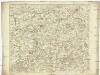
Carte topographique tres exacte
1 : 230000 Belgie W. D. S. Jaeger, Johann Christian I.C. Iaeger
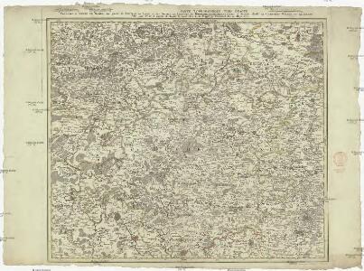
Carte topographique d'Allemagne
1 : 224000 Bouillon (Belgie) Jaeger, Johann Wilhelm Abraham I.W.A. Iaeger
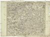
Carte topographique d'Allemagne
1 : 224000 Limburg (Belgie : provincie) Jaeger, Johann Wilhelm Abraham I. W. A. Iaeger
Karte vom Kriegestheater der vereinigten preussischen und östreichischen Armeen in Frankreich in VI. Blättern, [Blatt 3 und 5]
2 Teile auf 2 Blättern : 48 x 38 cm Königl. preuss. Akademische Kunst- und Buchhandlung
L'Eveche et l'Etat de Liege
1 : 240000 Mollova mapová sbírka Seutter, Matthäus Seutter, Matthäus
La Basse Partie de l'Estat et Seigneurie de l'Evesché de Lyege &c.
1 : 240000 Mollova mapová sbírka Sanson, Guillaume Mortier, Pierre
La Basse Partie De L'Estat Et Seigneurie De L'Evesché De Lyege &c. [Karte], in: Atlas nouveau, contenant toutes les parties du monde [...], Bd. 1, S. 210.
1 Karte aus Atlas Sanson, Nicolas Jaillot, Alexis Hubert und Mortier, Pieter
Sheet 7, uit: Stanford's large scale map of the seat of war / Stanford's Geographical Estab[lishmen]t
1 : 300000 Stanford's Geographical Establishment, Londen London : Stanford
Givet 97, uit: Special-Karte von Mittel-Europa / nach amtlichen Quellen bearbeitet von W. Liebenow
1 : 300000 titelvariant: W. Liebenow's Mittel-Europa; Annotatie: Titel boven de bladen: W. Liebenow's Mittel-Europa Johannes Wilhelm Liebenow 1822-1897 Frankfurt a. M. : Ludwig Ravenstein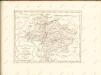

Leodiensis Dioecesis. [Karte], in: Le théâtre du monde, ou, Nouvel atlas contenant les chartes et descriptions de tous les païs de la terre, Bd. 1, S. 369.
1 Karte aus Atlas Blaeu, Willem Janszoon und Blaeu, Joan Blaeu, Willem Janszoon
Leodiensis Dioecesis. [Karte], in: Theatrum orbis terrarum, sive, Atlas novus, Bd. 1, S. 403.
1 Karte aus Atlas Blaeu, Joan Blaeu, Willem Janszoon
Leodiensis Dioecesis. [Karte], in: Novus Atlas, das ist, Weltbeschreibung, Bd. 1, S. 342.
1 Karte aus Atlas Blaeu, Joan Blaeu, Willem Janszoon


LEODIENSIS | DIOECESIS.
Amsterdami | Apud Guiljelmum et Ioannem Blaeu.
Carte du Pais situe entre Peronne Guise Mons Lille et Bethune
1 : 200000 Mollova mapová sbírka Le Rouge, Georges-Louis Le Rouge, Georges-Louis
Ducatus Luxemburg distinctis limitibus majorum et minorum ditiorum
1 : 330000 Lucemburk (Lucembursko) Seutter, Matthäus a Matthaeo Seutter
Leodiensis Dioecesis Typvs
1 : 330000 Mollova mapová sbírka Ortelius, Abraham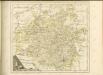

Ducatus Luxemburg
1 : 316000 Mollova mapová sbírka Seutter, Matthäus Seutter, Matthäus Seutter, Matthäus
Ducatus Luxemburgi
1 : 316000 Mollova mapová sbírka Homann, Johann Baptist Homann, Johann Baptista
Le Duché de Luxembourg
1 : 330000 Mollova mapová sbírka Fer, Nicolas de Starckman, P. Fer, Nicolas de
Carte Contenant le Pais entre Namur, Liege, Meziere te Arlon
1 : 200000 Mollova mapová sbírka Le Rouge, Georges-Louis Le Rouge, Georges-Louis
Area Bella Gerentium in Gallia et Belgio :
1 : 585000 Mollova mapová sbírka Valk, Gerhard
Givet 97, uit: [W. Liebenow's Special-Karte von Mittel-Europa]
1 : 300000 titelvariant: W. Liebenow's Mittel-Europa; Annotatie: Titel boven de bladen: W. Liebenow's Mittel-Europa Johannes Wilhelm Liebenow 1822-1897 Hannover : Hermann Oppermann
[21], uit: Hydro-Oro und Chorographische General Karte des Koenigreichs der Niederlande und der angrenzenden Länder bis Paris : mit der Angabe der Kunst und Heer-Strassen und der Entfernung der Poststationen / ... zusammengetragen und reducirt von ... Wilhelm Müller
1 : 400000 titelvariant: Generalkarte des Koenigreichs Hannover; Annotatie: 1e supplement bij: Generalkarte des Koenigreichs Hannover (1818) Müller, Wilhelm (fl. 1818) [Hannover : Wilhelm Müller]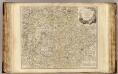
Luxembourg.
1 : 275500 Robert de Vaugondy, Gilles, 1688-1766
Le Duché de Luxembourg divisé en Quartier Walon, et Allemand
1 : 140000 Mollova mapová sbírka Jaillot, Alexis-Hubert Jaillot, Alexis Hubert