Maps of Arcadia Regional Unit

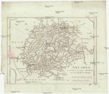
Arcadia
1 : 640000 Arkádie (Řecko) Barbié du Bocage, Jean Denis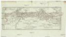
Corinth, Sicyon, Phliasia und Achaia
1 : 640000 Achaia (Řecko) Barbié du Bocage, Jean Denis
Greece 1:100,000, Tripolis
Sheet K7 of the map series: Greece. (Albania) 1 : 100,000. M.D.R. 610. [G.S.G.S. 4439] [London] : War Office
Plan der Ebene Von Tripolitza In Morea
Tripolis, Arkadien Barbié du Bocage, Jean Denis ; Riedel, Karl Traugott
Versuch einer Topographie von Sparta und dessen umliegender Gegend
1 : 19400 Sparta (starověký řecký stát)
Besond. Plan v. Tripolitza [Nebenkarte]
Tripolis, Arkadien Barbié du Bocage, Jean Denis ; Riedel, Karl Traugott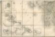
Bez titulu: La Grece

Olympia
Olympia Antike
Morea olim Peloponnesus
1 Karte : Kupferdruck ; 32 x 40 cm Hondius; Mercator Henricus Hondius
Morea olim Peloponnesus
1 Karte : Kupferdruck ; 32 x 40 cm Mercator s.n.
Peloponnesus
1 : 1100000 Peloponés (Řecko) Metzeroth, Carl
Morea
1 : 3000000 Peloponnes
Peloponesus hodie Moreae Regnum in Omnes suas Provincias Veteres et Hodiernas accurate divisum
1 : 850000 Mollova mapová sbírka Homann, Johann Baptist Homann, Johann Baptista - dědici
Achaia vetvs et nova
1 : 400000 Achaia (Řecko) Homann, Johann Baptist Homann, Johann Christoph â Io. Bapt. Homanno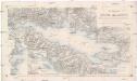
Der Meerbusen von Korinth oder Lepanto
1 : 200000 Korintský záliv (Řecko : oblast) Stanley, Owen Mannsell, A. L. Depot de la guerre
Elis und Triphylia
1 : 640000 Peloponés (Řecko) Barbié du Bocage, Jean Denis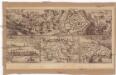
Coron
Koroni (Řecko) Zedtwitz, Curt Drda, Josef Jan Alois

Peloponesus hodie Morea ad normam veterum et recentiorum mappar
1 : 900000 Achaia (Řecko) Seutter, Matthäus Matth. Seutter
MOREA | olim | PELOPONNESVS
Guilj. Blaeu exc.
Peloponnesus
Peloponnes Verwaltungsgliederung
Morea olim Peloponnesus. [Karte], in: Novus Atlas, das ist, Weltbeschreibung, Bd. 3, S. 344.
1 Karte aus Atlas Blaeu, Joan Blaeu, Willem Janszoon
Southern Greece, with the adjacent Islands
1 : 1100000 Arrowsmith, Aaron Jr.

Peloponesvs sive Morea
1 : 1100000 Peloponés (Řecko) Laurenberg, L.
Morea olim Peloponnesus [Karte], in: Novus atlas absolutissimus, Bd. 5, S. 289.
1 Karte aus Atlas Janssonius Offizin
Morea olim Peloponnesus [Karte], in: Gerardi Mercatoris et I. Hondii Newer Atlas, oder, Grosses Weltbuch, Bd. 2, S. 333.
1 Karte aus Atlas Mercator, Gerhard und Hondius, Jodocus Jansson, Jan
Morea ilim Peloponnesus. [Karte], in: Theatrum orbis terrarum, sive, Atlas novus, Bd. 3, S. 294.
1 Karte aus Atlas Blaeu, Joan Blaeu, Willem Janszoon