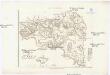
Maps of Regional Unit of Piraeus
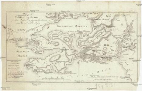
Plan des Treffens bey Salamis
1 : 110000 Salamís, ostrov (Řecko) Barbié du Bocage, Jean Denis
[Athen]
1 : 625000 Athen
Umgebungen von Athen
Athény (Řecko) F. Tempsky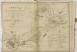

Athen
1 : 150000 Athen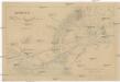
Athenae cum portibus Piraeo et Phalereo et regione adjacente in usum scholarum descripta
Athény (Řecko) Köb, Kajetano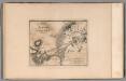
Plan of the environs of Athens. No. 8
1 : 56000 Barbie du Bocage, Jean Denis
Plan der umliegenden Gegend von Athen
1 : 55000 Athény-oblast (Řecko) Barbié du Bocage, Jean Denis Choiseul-Gouffier, Marie-Gabriel-Florent-Auguste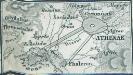
[Athenae-Piraeus]
Athen, Piräus, Antike
Athen und Umgegend
1 : 200000 Athen
Plan der Akademie und der umliegenden Gegend
1 : 12000 Athény (Řecko) Barbié du Bocage, Jean Denis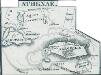
Athenae
Athen Antike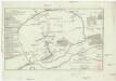
Plan von Athen
1 : 12000 Athény (Řecko) Barbié du Bocage, Jean Denis
Plan von Athen
Athény (starověký řecký stát) Fauviel Gleditsch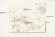
Plan von Athen
1 : 10406 Athény (starověký řecký stát) Müller, Karl Otfried Gleditsch
<Athēnai kai sinoikismoi : klimax 1:8000, oiadēpote anatypōsis apagoreuetai.>
1 : 8000 Ekdotikos Chartographikos Oikos K. Grēgoura Εκδοτικος Χαρτογραφικος Οικος Κ. Γρηγουρα = Ekdotikos Chartographikos Oikos K. Grēgoura
Athènes et ses environs
Kalergis, Emmanuel Imp. Lemercier
Athen mit Umgebung
1 : 125000 Kaupert, Johann August, 1822-1899 von Dietrich Reimer
Plan von Athen
1 : 100000 Athen
Carte aerotopographique a ́ Athens
1 : 10000 Athény (Řecko)
<Schedion Athenōn : emphainon tēn te néan pólin tò archaīon Asty, synoikías, kōmas kaì périx dēmos hōs eichon tò pálai kaì tous neōtérous
1 : 12500 Geōrgiadēs, Athan. S
Athens
1 : 8500 Athény (Řecko) Clarke, W. B. Henshall, J. Baldwin & Cradock
Athènes - b 1837
1 : 10000 Aldenhoven, Ferdinand Lithographie Royale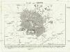
Plan von Athen
1 : 13300 Athény (Řecko) F. A. Brockhaus
Athen
1 : 16500 Griechenland Athen
Athens
1 : 8250 Clarke, W. B published under the auspices of the Society of the Diffusion of Useful Knowledge [by] George Cox
Italien und Balkanhalbinsel. Nebenkarten II. 1. Athen und der Isthmus von Korinth
Attika
Chartes Attikes
1 : 100000 Atika, poloostrov (Řecko) Eleutheroudakes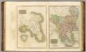
Attica, Turkey in Europe.
Thomson, John