Maps of Δήμος Λήμνου

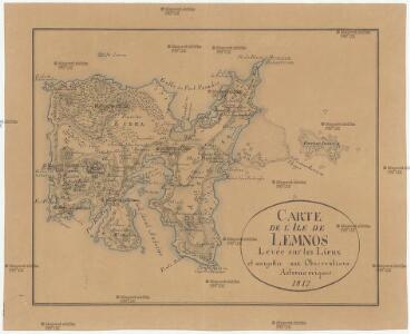
Carte de l'Ile de Lemnos
Limnos, ostrov (Řecko)
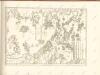
Insular. Aliquot Aegaei Maris Antiqua Descrip.[:] [Lemnos.] [Karte], in: Theatrum orbis terrarum, S. 517.
1 Karte aus Atlas Ortelius, Abraham Vrients, Jan Baptista
Insular. Aliquot Aegaei Maris Antiqua Descrip.[:] [Lemnos.] [Karte], in: Theatrum orbis terrarum, S. 419.
1 Karte aus Atlas Ortelius, Abraham
Aegean islands - Lemnos, Samos, Mytilini, Methymna, Series MDR 547
Aegean islands - Lemnos, Samos, Mytilini, Methymna, Series MDR 547. Great Britain. Army. Royal Engineers. Field Survey Company, 512th. [Cairo] : [Survey Directorate, Middle East]
Mediterranean. Aegean. Lemnos Island. Port Mudros.--Porto San Antonio.--Surveyed ... 1916
Mediterranean. Aegean. Lemnos Island. Port Mudros.--Porto San Antonio.--Surveyed ... 1916. Natural scale, 1 : 17,000. London : Admiralty
Archipelagi Insularum Aliquot Descrip., [Stalimene] [Karte], in: Theatrum orbis terrarum, S. 246.
1 Karte aus Atlas Ortelius, Abraham
Archipelagi Insularum Aliquot Descrip., [Stalimene] [Karte], in: Theatrum orbis terrarum, S. 341.
1 Karte aus Atlas Ortelius, Abraham Vrients, Jan Baptista
Stalimini I. [Karte], in: Gerardi Mercatoris Atlas, sive, Cosmographicae meditationes de fabrica mundi et fabricati figura, S. 523.
1 Karte aus Atlas Mercator, Gerhard Montanus, Petrus
Plan Afonskago sraženīja Ījunja 19 dnja 1807 goda
Griechenland Athos Seeschlacht
Saloniki, Seres, Xanthi, Kastro, Pharsalos
1 : 750000 Fársala (Řecko) Budik, A. K. u. k. Militärgeographisches Institut
Salonik, Seres, Xanthi, Kastro, Phersala
1 : 750000 Soluň (Řecko) K. k. militär-geographisches Institut
Übersichtskarte von Mittel - Europa

Schema k dějstvījam Senjavina i Grejga v Archipelagě v 1807 godu
Türkei Seeschlacht Senjavin, Dmitrij Nikolaevič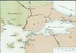
[Konstantinopel]
Istanbul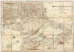
Karte vom Östlichen Rumelien
1 : 540000 Východní Rumelie Kiepert, Heinrich Dietrich Reimer
MARIS ÆGÆI, | quod hodie | ARCHIPELAGO | nuncupatur, | PARS SEPTENTRIONALIS.
Auctore | IOANNE LAVRENBERGIO. [Amsterdam : Joan Blaeu]
Insularum Archipelagi Septentrionalis seu Maris Aegaei Accurata Delinatio [Karte], in: Novus atlas absolutissimus, Bd. 10, S. 219.
1 Karte aus Atlas Janssonius Offizin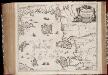
Insvlarvm Archipelagi Septentrionalis seu Maris Aegaei accurata delinatio / autore I. Laurenbergio
1 : 1100000 Annotatie: Jaar van uitg. van kaart ligt in de periode 1650-1662; Origineel is Blad 172 in atlas factice; Verso is blanco; Annotatie geografische gegevens: 4 schaalstokken op de kaart: 7 Mil. Germ., en: 10 Mil. Gall., en: 28 Mil. Ital., en 275 Stadia [Amstelodami] : [Apud Ioannem Ianssonium]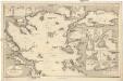
Mittelmeer
1 : 600000 Bulharsko Reichs-Marine-Amt
Karte von dem Alten Macedonien Thessalien und Epirus
Epirus (Řecko) Baumgarten, Siegmund Jakob Johann Justinus Gebauer
Demilitarized zones in north-west Turkey
1 : 1000000 Demilitarized zones in north-west Turkey. Illustrates post-war settlement. War Office
Balkans 1 000 000e. Constantinople
1 : 1000000 France. Service géographique de l'armée [Paris] : Service géographique de l'armée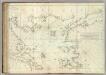
Carte De La Mer Mediterranee. XII.
Roux, Joseph
Boundary of demilitarized zone about Constantinople
1 : 1000000 Meeting of Alllied Naval and Military Advisers, London 16.2.20. Demilitarized zones in north-west Turkey. Illustrates post-war settlement. War Office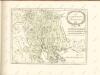

[Marmarameer]
Türkei Marmarameer Seeschlacht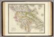
Greece.
1 : 1425000 Teesdale, Henry
Iles de L'archipel; Dschezaïr
Nouvel atlas physique politique et historique de l'Empire ottoman et des états limitrophes en Europe, en Asie et en Afrique, en quarante feuilles Hellert, J.J. Bellizard, Dufour et Cie
Makedonien heute
Makedonien Staatsgrenze Zwick, J. ; Aarbakke, V.