Maps of gmina Żary

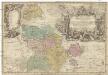
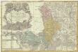
Das Fürstenthum Sagan in Nieder-Schlesien
1 : 280000 Zaháňsko (Polsko) Schleuen, Johann David Schleuen
Meßtischblatt 2480 : Hirschfeldau, 1933
1 : 250000 Hirschfeldau. - Hrsg. 1901, bericht. 1933. - 1:25000. - [Berlin]: Reichsamt für Landesaufnahme, 1933. - 1 Kt.
Meßtischblatt 2480 : Hirschfeldau, 1901
1 : 250000 Hirschfeldau. - Aufn. 1899. - 1:25000. - [Berlin]: Reichsamt für Landesaufnahme, 1901. - 1 Kt.
Meßtischblatt 2479 : Sagan, 1901
1 : 250000 Sagan. - Aufn. 1899. - 1:25000. - [Berlin]: Reichsamt für Landesaufnahme, 1901. - 1 Kt.
Meßtischblatt 2478 : Sorau, 1901
1 : 250000 Sorau. - Aufn. 1899. - 1:25000. - [Berlin]: Reichsamt für Landesaufnahme, 1901. - 1 Kt.
Meßtischblatt 4256 : Gassen, 1939
1 : 250000 Gassen. - Aufn. 1899, hrsg. 1901, bericht. 1933/37, letzte Nachtr. 1938, Ausg. 1939. - 1:25000. - [Berlin]: Reichsamt für Landesaufnahme, 1939. - 1 Kt.
Meßtischblatt 4257 : Christianstadt, 1939
1 : 250000 Christianstadt. - Aufn. 1899, hrsg.1901, bericht. 1933/37, Ausg. 1939. - 1:25000. - [Berlin]: Reichsamt für Landesaufnahme, 1939. - 1 Kt.
Meßtischblatt 4257 : Christianstadt, 1939
1 : 250000 Christianstadt. - Aufn. 1899, hrsg.1901, bericht. 1933/37, Ausg. 1939. - 1:25000. - [Berlin]: Reichsamt für Landesaufnahme, 1939. - 1 Kt.
Meßtischblatt 2407 : Briesnitz, 1936
1 : 250000 Briesnitz. - Hrsg. 1901, bericht. 1933, mehrfarb. Ausg. 1936. - 1:25000. - [Berlin]: Reichsamt für Landesaufnahme, 1936. - 1 Kt.
Meßtischblatt 2407 : Briesnitz, 1901
1 : 250000 Briesnitz. - Aufn. 1894/99. - 1:25000. - [Berlin]: Reichsamt für Landesaufnahme, 1901. - 1 Kt.
Meßtischblatt 4458 : Mallmitz, 1937
1 : 250000 Mallmitz. - Hrsg. 1901, bericht. 1933, gedr. [19]37. - 1:25000. - [Berlin]: Reichsamt für Landesaufnahme, 1937. - 1 Kt.
Meßtischblatt 2553 : Mallmitz, 1901
1 : 250000 Mallmitz. - Aufn. 1899. - 1:25000. - [Berlin]: Reichsamt für Landesaufnahme, 1901. - 1 Kt.
Meßtischblatt 2552 : Halbau, 1905
1 : 250000 Halbau. - Aufn. 1899, hrsg. 1901. - 1:25000. - [Berlin]: Reichsamt für Landesaufnahme, 1905. - 1 Kt.
Meßtischblatt 2551 : Ndr. Hartmannsdorf, 1901
1 : 250000 Ndr. Hartmannsdorf. - Aufnahme 1899. - 1:25000. - [Berlin]: Reichsamt für Landesaufnahme, 1901. - 1 Kt.
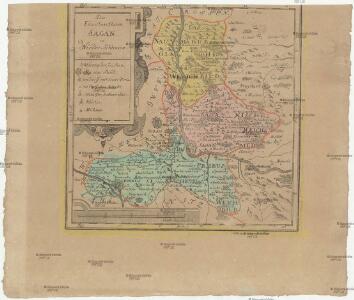
Das Fürstenthum Sagan in Nieder-Schlesien
1 : 260000 Mollova mapová sbírka Schleuen, Johann David Schleuen, Johann David
Meßtischblatt 2477 : Tzschecheln, 1901
1 : 250000 Tzschecheln. - Aufn. 1899. - 1:25000. - [Berlin]: Reichsamt für Landesaufnahme, 1901. - 1 Kt.
Meßtischblatt 2481 : Hartau, 1901
1 : 250000 Hartau. - Aufn. 1899. - 1:25000. - [Berlin]: Reichsamt für Landesaufnahme, 1901. - 1 Kt.
Meßtischblatt 4255 : Sommerfeld Ndr. Lausitz, 1939
1 : 250000 Sommerfeld Ndr. Lausitz. - Aufn. 1899, hrsg. 1901, bericht. 1933/37, red. Änd. 1.4.38, Ausg. 1939. - 1:25000. - [Berlin]: Reichsamt für Landesaufnahme, 1939. - 1 Kt.
Meßtischblatt 2404 : Sommerfeld, 1901
1 : 250000 Sommerfeld. - Aufn. 1899. - 1:25000. - [Berlin]: Reichsamt für Landesaufnahme, 1901. - 1 Kt.
Meßtischblatt 4259 : Freystadt in Niederschlesien, 1936?
1 : 250000 Freystadt in Niederschlesien. - Hrsg. 1901, bericht. 1933. - 1:25000. - [Berlin]: Reichsamt für Landesaufnahme, [1936?]. - 1 Kt.
Meßtischblatt 2550 : Zibelle, 1901
1 : 250000 Zibelle. - Aufn. 1899. - 1:25000. - [Berlin]: Reichsamt für Landesaufnahme, 1901. - 1 Kt.
Meßtischblatt 2554 : Sprottau, 1933 Sprottau
1 : 250000 Sprottau. - Hrsg. 1900, bericht. 1933. - 1:25000. - [Berlin]: Reichsamt für Landesaufnahme, 1933. - 1 Kt.
Meßtischblatt 2554 : Sprottau, 1903 Sprottau
1 : 250000 Sprottau. - Aufn. 1899, hrsg. 1900, einz. Nachtr. 1903. - 1:25000. - [Berlin]: Reichsamt für Landesaufnahme, 1903. - 1 Kt.
Meßtischblatt 2554 : Sprottau, 1900
1 : 250000 Sprottau. - Aufn. 1899, hrsg. 1900. - 1:25000. - [Berlin]: Reichsamt für Landesaufnahme, 1900. - 1 Kt.
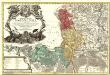
Principatus Silesiae Saganensis in suos Circulos Sagan, Priebus, et Naumburg divisi et
1 : 108000 Mollova mapová sbírka Wieland, Johann Wolfgang Homann, Johann Baptista - dědici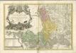
Principatus Silesiae Saganensis in suos circulos, Sagan, Priebus, et Naumburg divisi
1 : 110000 Zaháňsko (Polsko) Wieland, Johann Wolfgang Schubarth, Matthäus Haeredibus Homannianis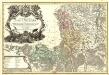
Principatus Silesiae Saganensis in suos Circulos Sagan, Priebus, et Naumburg divisi et.
1 : 108000 Mollova mapová sbírka Wieland, Johann Wolfgang Homann, Johann Baptista - dědici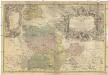
PRINCIPATVS SILESIAE GLOGOVIENSIS novissima Tabula Geographica
1 : 203000 Głogów (Polsko) Wieland, Johann Wolfgang Schubarth, Matthaeus ab Haeredibus Homannianis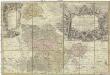
Principatvs Silesiae Glogoviensis novissima tabula geographica sistens 6 ejusdem circulos Glogav, Freystadt, Gvhrav, Sprottav, Grünberg et Schwiebvs, cum districtu Polckwitz nec non liberam dynastiam Bevthen et Carolath
1 : 208000 Głogów (Polsko) Wieland, Johann Wolfgang Schubarth, Matthäus Homannianos Heredes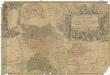