Maps of Haguenau-Wissembourg
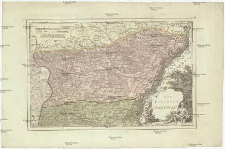
Der District Hagenau
1 : 182000 Haguenau (Francie)
Charte von der Grafschaft Hanau-Lichtenberg
1 : 180000 Grattenauer, Ernst C. Grattenauer
169. Strassburg i. Elsass, uit: Topographische Uebersichtskarte des Deutschen Reiches / herausgegeben v. d. Kartogr. Abt. d. Königl. Preuß. Landesaufnahme
1 : 200000 titelvariant: Topogr. Übersichtskarte des Deutschen Reiches; Annotatie: Titel boven bladen ook: Topogr. Übersichtskarte des Deutschen Reiches; Annotatie geografische gegevens: Op elk blad twee maatstokken: 10 Kilometer = 5,5 cm; 1 geogr. Meile = 3,6 cm; Legenda onder op elk blad Königlich Preußische Landesaufnahme. Kartographische Abtheilung [S.l : Königlich Preußische Landesaufnahme, Kartographische Abtheilung]
Alsatia inferior
1 Karte : Kupferdruck ; 17 x 27 cm Specklin; Quad Johannes Bussemacher
Alsatia inferior
1 Karte : Kupferdruck ; 14 x 22 cm Lambert Andreae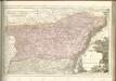
[Strasbourg]
1 Blatt : 60 x 92 cm s.n.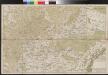
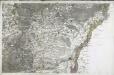
Carte über den groesten Theil des untern Elsasses, nebst der Grenze von Teutschland und Lotharingen. &c.
Bechstatt, I. C.
Le cours du Rhin de Bâle à Hert près Philisbourg contenant l'Alsace et partie du Brisgau, 4
1 Blatt : 76 x 52 cm Le Rouge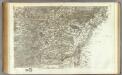
162 Strasbourg.
1 : 86400 Cassini family; Cassini, Cesar-Francois, 1714-1784
Alasatia superior et inferior III. tabulis delineata, 3
1 Blatt : 62 x 59 cm s.n.
Le Flambeau de la Guerre Allumee au Rhin
Mollova mapová sbírka Delisle, Guillaume Schenk, Peter II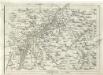
Geographica Provinciarum Sveviae Descriptio =
Mollova mapová sbírka Hurter, Johann Christoph Bodenehr, Johann Georg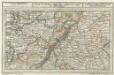
Fortlovis mitt der Gegend auff 6 Stunden.
1 : 250000 Mollova mapová sbírka Bodenehr, Gabriel Bodenehr, Gabriel
Chorographia Argentorati Alsatiæ metropolis
1 Karte : Kupferdruck ; 47 x 56 cm Seutter Matthäus Seutter
Argentorati territorium, vulgo Strasburger Gebiet
1 Karte : Kupferdruck ; 46 x 57 cm Allard by I. Cóvens et C. Mortier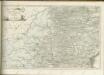

Le Theatre de la Guerre Sur le Haut Rhein
1 : 142000 Mollova mapová sbírka Sanson, Guillaume
Argentorati Territorium, vulgo Strasburger Gebiet Cum Maxima Episcopatus Cognominis, ac Occidentaliori Badensis Marchionatus Parte &c.
1 : 120000 Mollova mapová sbírka Allard, Carel Allard, Carel
Chorographia Argentorati Alsatiae Metropolis
1 : 85000 Mollova mapová sbírka Seutter, Matthäus Seutter, Matthäus
Territorium Argentoratense
1 : 625000 Štrasburk (Francie) Janssonius, Johannes Ioannes Iansonius
Territorium Argentoratense
1 : 600000 Štrasburk (Francie) Janssonius, Johannes Ioannes Iansonius
Le cours du Rhin de Bâle à Hert près Philisbourg contenant l'Alsace et partie du Brisgau, 5
1 Blatt : 77 x 52 cm Le Rouge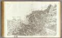
161 Landau, Wissembourg.
1 : 86400 Cassini family; Cassini, Cesar-Francois, 1714-1784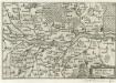
Fort-Louys
1 : 170000 Mollova mapová sbírka Person, Nikolaus Person, Nicolas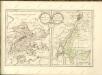

Le Flambeau de la Guerre Allumee au Rhin
Mollova mapová sbírka Delisle, Guillaume Schenk, Peter II
Blatt X: Molsheim, uit: Karte der Vogesen / herausgegeben vom Central-Ausschuss des Vogesen-Clubs ; bearbeitet im kartographischen Institut von Carl Flemming in Glogau
1 : 500000 Annotatie: Bladwijzer op omslag; Annotatie geografische gegevens: Legenda Vogesen-Club. Central-Ausschuss Strassburg : in Kommission bei J.H. Ed. Heitz (Heitz & Mündel)
Geologische Karte der Umgebungen von Baden
1 : 50000 Nordblatt Sandberger, Fr. Chr. Fr. Müller'sche Hofbuchhandlung