Maps of Reni
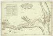
Plan preslědovanija za neprijatelem korpusom gospodina generala kvartermistra Bauera, do rěki Dunaja 21. julja v četvertago času po poludni iz zanjatago lagerja po pobědě nad neprijatelem pri rječki Kagulě, na kotorom naznačen i prežnej retrašament neprijatelskoj 1770 godu julja 23. dnja
1 : 7500 Besarábie (Moldavsko a Ukrajina)
Lambert-Cholesky sheet 5356 (Câsliţa)
1 : 20000 Romanian military topographic map sheet under Lambert-Cholensky projection Serviciul Geografic al Armatei geo-spatial.org Serviciul Geografic al Armatei
Lambert-Cholesky sheet 5355 (Pisica)
1 : 20000 Romanian military topographic map sheet under Lambert-Cholensky projection Direcția Topografică Militară geo-spatial.org Direcția Topografică Militară
Lambert-Cholesky sheet 5354 (Văcăreni)
1 : 20000 Romanian military topographic map sheet under Lambert-Cholensky projection Direcția Topografică Militară geo-spatial.org Direcția Topografică Militară
Lambert-Cholesky sheet 5357 (Slobozia Mare)
1 : 20000 Romanian military topographic map sheet under Lambert-Cholensky projection Serviciul Geografic al Armatei geo-spatial.org Serviciul Geografic al Armatei
Lambert-Cholesky sheet 5454 (Luncavița)
1 : 20000 Romanian military topographic map sheet under Lambert-Cholensky projection Institutul Geografic Militar geo-spatial.org Institutul Geografic Militar
Lambert-Cholesky sheet 5256 (Tuluceşti)
1 : 20000 Romanian military topographic map sheet under Lambert-Cholensky projection Direcția Topografică Militară geo-spatial.org Direcția Topografică Militară
Lambert-Cholesky sheet 5255 (Galati)
1 : 20000 Romanian military topographic map sheet under Lambert-Cholensky projection Institutul Geografic al Armatei geo-spatial.org Institutul Geografic al Armatei
Mačinski budžak
1 : 300000 Rumänien Dobrudscha
Ostia Danubij
Mollova mapová sbírka Hoffmann, Johannes Hoffmann, Johann
Harta Cailor de Comunicatie din Jud. Covurluiu
Rumänien Judeţul Covurlui Verkehrsweg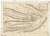
Plan dviženii ataki i soveršennoj pobědy oderžannoj vojskami Jeja Imperatorskago Veličestva nad Turkami pod komandoju ver'chovnago vizirja v Bessarabii pri rěčkě Kagulě 1770 goda ijulja 21. dnja
1 : 21000
Charte der bei Mascineni und Galatz vorgefallenen Treffen am 16. April, u. i. Mai 1789 / Weinrauch
1 Karte : Kupferdruck ; 12 x 17 cm Weinrauch, Johann Caspar [Trattner]
Lambert-Cholesky sheet 5254 (Vădeni)
1 : 20000 Romanian military topographic map sheet under Lambert-Cholensky projection Direcția Topografică Militară geo-spatial.org Direcția Topografică Militară
Lambert-Cholesky sheet 5257 (Şiviţa)
1 : 20000 Romanian military topographic map sheet under Lambert-Cholensky projection Direcția Topografică Militară geo-spatial.org Direcția Topografică Militară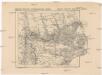
Russisch türkischer Kriegsschauplatz in Europa
1 : 584000 Dunaj-delta (Rumunsko a Ukrajina) Alois Hynek
Donaudelta
1 : 5000000 Donaudelta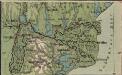
Italien und Balkanhalbinsel. Nebenkarten II. 4. Donaudelta
Donaudelta
Gouv. 25. Kiew, 27. Pultawa
1 : 2200000 1 Karte : Lithographie ; 19 x 27 cm Schlieben, W.E.A. von [Georg Joachim Göschen]
Donau-Delta
1 : 2000000 Donaudelta
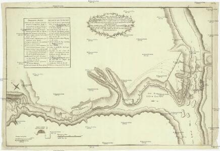
Plan des tapfern Angriffs und vollkommenen Sieges der russisch-kayserlichen Waffen über die Turkische und Tatarische Arméé an der Large in der Moldau den 7. Iuly 1770
1 : 40000 Moldavsko
Trigonometrisk grunnlag, vedlegg 65, 2-5: Grunnlagspunkter for Struves meridianbue fra Bessarabia og Volhynia
1 : 200000 de Tenner
Carte de la Roumanie et pays limitrophes. Galatz
1 : 500000 France. Service géographique de l'armée [Paris] : Service géographique de l'armée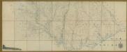
Carte de la Moldavie
1 : 330000 Moldawien, Bessarabien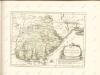

Bez titulu: Šest listů speciálních map Ukrajiny

Galati. Medgidia. Ismail. Silistra. Balcic

Galaz, Medžidie, Ismail, Silistria, Balčik
1 : 750000 Balčik (Bulharsko) Budik, Ad. K. u. k. Militärgeographisches Institut
Galaz, Medžidie, Ismail, Silistria, Balčik
1 : 750000 Balčik (Bulharsko) K. k. militär-geographisches Institut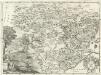
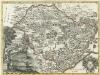
Moldavia.
1 : 1800000 Mollova mapová sbírka Bruggen, Johann van der Brugge, Johannes van der