Maps of Vaud
Carte du Lac de Geneve et de ses environs
1 : 320000 Ženeva (Švýcarsko : kanton)
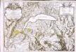
Novissima totius Lavsonii sive Lemani Lacvs
1 : 180000 Mollova mapová sbírka Chopy, Antoine Homann, Johann Baptista - dědici
Plus grande partie de la Suisse Romande ou République Lémanique.
From Atlas Suisse. Levé et dessiné par J. H. Weiss aux fraix de J. R. Meyer á Aarau dans les années 1786 á 1802. Gravée par Guerin, Eichler, et Scheurmann.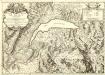
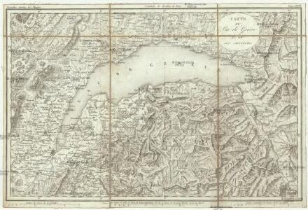
Carte du Lac de Geneve et des Pays Circonvoisins
1 : 150000 Mollova mapová sbírka Chopy, Antoine Daudet, Jean-Louis Chopy, Antoine
Novissima totius Lavsonii sive Lemani lacvs cum regionibus circumjacentibus chorographica repraesentatio
1 Karte : Kupferdruck ; 46 x 58 cm Rizzi-Zannoni; Chopy excudentibus Homannianis Heredibus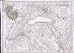
Carte du lac de Geneve et des pays circonvoisins où se trouvent les frontieres de France de Savoye et de Suisse
1 Karte : Kupferdruck ; 48 x 65 cm Rovéréa; Fatio de Duillier; Buache; Chopy; Dezauche chez Dezauche successeur des S.rs de l'Isle et Buache 1.rs geographes du roi rue des Noyers près celle des Anglois
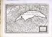
Carte du lac de Geneve et des pays circonvoisins
1 Karte : Kupferdruck ; 48 x 65 cm Rovéréa; Fatio de Duillier; Buache; Chopy Philippe Buache sur le quay de la Megisserie au St. Esprit pres le pont Neuf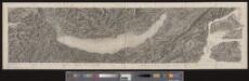
[Malerisches Relief der Schweizer- und angränzenden Alpen]
1 : 135000 11 Vogelschaukarten Nach der Natur aufgenommen und gezeichnet von F.W. Delkeskamp ; gestochen v. Knopfmacher u. J.Ph. Dauch [Friedrich Wilhelm Delkeskamp], [Frankfurt am Main]
Atlas Suisse
1 : 120000 16 Karten levé et dessiné par J.H. Weiss [et Joachim Eugen Müller] aux frais de J.R. Meyer à Aarau dans les années 1786 à 1802 ; gravée [sic] par [Christophe] Guérin, [Matthias Gottfried] Eichler et [Johann Jakob] Scheurmann [Johann Rudolf Meyer], Aarau
Carte du lac de Geneve et des pays circonvoisins
1 Karte auf 2 Blatt : Kupferdruck ; 55 x 80 cm Rovéréa; Fatio de Duillier; Daudet; Chopy Antoine Chopy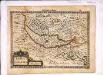
Lacus Lemannus
1 Karte : Kupferdruck ; 17 x 24 cm Mercator Cloppenburgh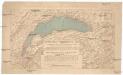
Compagnie Générale de Navigation sur le lac Léman
Labarthe, E. Compagnie générale de navigation sur le lac Léman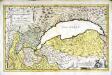
Dvcatvs Chablasivs et lacvs Lemanvs
1 Karte : Kupferdruck ; 36 x 58 cm Blaeu; Borgonio; Broen; Ottens; Ottens invenitur apud R. et I. Ottens geographos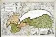
Dvcatvs Chablasivs et lacvs Lemanvs
1 Karte : Kupferdruck ; 36 x 58 cm Blaeu; Borgonio; Broen Joannes Blaeu excudit
Lacus Lemanni Locorumque Circumiacentium Accuratissima Descriptio. [Karte], in: Theatrum orbis terrarum, sive, Atlas novus, Bd. 2, S. 160.
1 Karte aus Atlas Blaeu, Joan Blaeu, Willem Janszoon
Lacus Lemanni Locorumque Circumiacentium Accuratissima Descriptio. [Karte], in: Novus Atlas, das ist, Weltbeschreibung, Bd. 2, S. 82.
1 Karte aus Atlas Blaeu, Joan Blaeu, Willem Janszoon
Lac Leman
1 Karte : Kupferdruck ; 13 x 19 cm s.n.
Lacvs Lemanni locorvmqve circvmiacentivm accvratissima descriptio
1 Karte : Kupferdruck ; 41 x 53 cm Goulart; Blaeu apud Guiljelmum Blaeu
Lacvs Lemani vicinorvmq. locorvm nova et accvrata descriptio
1 Karte : Kupferdruck ; 35 x 47 cm Hondius Judocus Hondius excudit
Lacus Lemanni Locorumque Circumiacentium Accuratissima Descriptio. [Karte], in: Novus atlas absolutissimus, Bd. 4, S. 236.
1 Karte aus Atlas Janssonius Offizin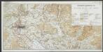
Lacus Lemanni Locorumque Circumiacentium Accuratissima Descriptio. [Karte], in: Le théâtre du monde, ou, Nouvel atlas contenant les chartes et descriptions de tous les païs de la terre, Bd. 2, S. 80.
1 Karte aus Atlas Blaeu, Willem Janszoon und Blaeu, Joan Blaeu, Willem Janszoon
Lacus Lemanni Locorumque Circumiacentium Accuratissima Descriptio. [Karte], in: Gerardi Mercatoris et I. Hondii Newer Atlas, oder, Grosses Weltbuch, Bd. 2, S. 149.
1 Karte aus Atlas Mercator, Gerhard und Hondius, Jodocus Jansson, Jan
LACVS LEMANNI | LOCORVMQVE CIRCVM- | IACENTIVM ACCVRATIS- | SIMO DESCRIPTIO
Auctore | IACOBO GOVLARTIO GENEVENSI. Apud Guiljelmum Blaeu.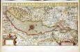
Chorographica tabula lacus Lemanni locorumqve circumiacentium
1 Karte : Kupferdruck ; 29 x 54 cm Mercator; Hondius; Goulart Henricus Hondius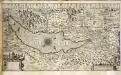
Chorographica tabula lacus Lemanni locorumqve circumiacentium
1 Karte : Kupferdruck ; 29 x 54 cm Mercator; Hondius; Goulart Jodocus Hondius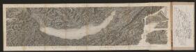
[Malerisches Relief der Schweizer- und angränzenden Alpen]
Delkeskamp, Friedrich Wilhelm F.W. Delkeskamp
Carte de la Suisse avec les plans des cheflieux des 22 cantons
1 : 200000 1 Karte auf 8 Bl. dessinée et publié par Henri Keller ; Lithogr. von J. Schweizer = Charte der Schweiz mit den Grundrissen der Hauptorte der 22 Cantone Keller, Zürich