Maps of Siberia
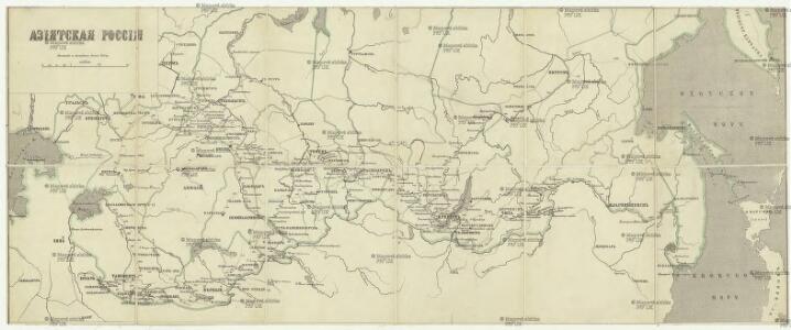
Azijatskaja Rossija
1 : 10500000 Rusko východní
A generall mapp of the Kingdome of Tartaria / designed by Monsieur Sanson, Geographer to the French
1 : 16000000 1 Karte : Kupferdruck ; 25 x 38 cm Sanson, Guillaume [Richard Blome]
Tartaria sive Magni Chami Imperium. [Karte], in: Theatrum orbis terrarum, sive, Atlas novus, Bd. 2, S. 264.
1 Karte aus Atlas Blaeu, Joan Blaeu, Willem Janszoon
Ethnographische Karte des Asiatischen Russlands
Russland Russland / Asiatischer Teil Ethnische Gruppe
Tartaria sive Magni Chami imperivm
1 : 13000000 1 Karte : Kupferdruck ; 38 x 50 cm [Blaeu]
Tartaria sive Magni Chami imperiorum
1 : 14000000 1 Karte : Kupferdruck ; 25 x 33 cm Blaeu, Joan [Merian]
Tartaria sive Magni Chami imperiorum
1 : 14000000 1 Karte : Kupferdruck ; 25 x 33 cm Blaeu, Joan [Merian]
Nova descriptio geographica Tattariae magnae tam orientalis quam occidentalis in particularibus et generalibus territoriis una cum delineatione totius imperii Russici imprimis Siberiae accurate ostensa
1 : 6730000 Asie Strahlenberg, Philipp Johann von Frisch, P. J.
Nova descriptio geographica Tattariae Magnae tam orientalis quam occidentalis in particularibus et generalibus teritoriis una cum delineatione totius imperii Russici imprimis Siberiae accurate ostensa
1 : 6730000 Asie Strahlenberg, Philip Johan von Frisch, P. J.
An accurate map of the Russian empire both in Europe and Asia / Engraved for Guthries new System of
1 : 19000000 1 Karte : Kupferdruck ; 32 x 40 cm Dilly, Charles Published as the Act directs by C. Dilly & G. Robinson
Carte generale des etats du Czar empereur de Moscovie, ou l'on voit ce que ce prince possede en Euro
1 : 9500000 1 Karte auf 2 Blatt : Kupferdruck ; 36 x 62 cm Châtelain, Zacharias L'Honore et Châtelain
Standorte der höheren Kommandos in Asien
Russland Russland / Asiatischer Teil Militär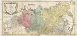
Carte géographique contenant le royaume de Siberie
1 : 13000000 Asie střední Lotter, Matthäus Albrecht publiée par Tobie Conrad Lotter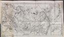
Asiatisches Rusland
Russland Russland / Asiatischer Teil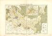
Atlas für Industrie- und Handelsgeographie: Für commercielle und technische Lehranstalten, für Kaufleute und Industrielle

A New Description of Tartarie / by Robt. Morden
1 : 43000000 1 Karte : Kupferdruck ; 11 x 13 cm Morden, Robert [Printed for Robert Morden and Thomas Cockerill]
Tartarie septentrionale et orientale suivant Monsr. Witsen et les meilleures relations
1 : 10000000 A Amsterdam : chez Jean Fred. Bernard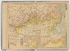
中俄交界詳圖 .
1 : 14400000 中俄交界詳圖 宣统元年至二年[1909-1910],武昌:武昌亞新地學社出版 该图集以1幅总图15幅详图(分图)的形式,详细绘制了清末中俄边界线以及清代中俄边界的变化,空间上东起乌苏里江、图们江,向西延黑龙江、蒙古、新疆直到帕米尔地区。详图中详细标注了边界上各界牌所在位置及名称。 该图未标注成图时间,根据图上内容推测应为宣统元年至二年。详图第十幅中,吉林宁古塔标注了绥芬府,而绥芬府是宣统元年[1909]四月升绥芬厅而置,次年四月又改为宁安府,因此该图应成图于宣统元年或二年。图上其他标注也符合这一时间限定,如总图中已绘制了京张铁路,而京张铁路通车时间是1909年,表明该图应在1909年或之后;北京处则标注为“順天京師”,而顺天府于民国二年被废,京师改为京兆地方,表明该图应在1913年之前。因此,该图成图时间应在宣统元年至二年之间,其中,又以宣统二年上半年的可能性最大。 1集16图,彩印,中文,图幅为36.5 x 47.6 cm,总图比例尺1:14400000,详图比例尺1:1500000,以穿过北京的116°经线为中央经线,总图经纬度范围约为E50°-145°; N40°-60°。 Harvard-Yenching | Offsite Storage C (HD) | G2306.F2 H93 1930Z;Hollis Number:012092643 武昌:武昌亞新地學社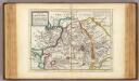
Great Tartary.
1 : 26000000 Moll, Herman, d. 1732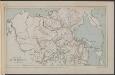
Map of the Amur Region
Russland Sibirien Amur Philip, George ; Philip, [Sohn v. G.]
General'naja karta azijatskoj časti Rossijskoj imperii
1 : 26000000 Rusko východní Korsakov, P.
Carte de la Sibérie et des pays voisins / par le Sr. Bellin Ing. de la Marine
1 : 14500000 1 Karte : Kupferdruck ; 27 x 44 cm Bellin, Jacques Nicolas [Bellin]
Carte de la Sibérie et des pays voisins / par le Sr. Bellin Ing. de la Marine
1 : 14500000 1 Karte : Kupferdruck ; 27 x 44 cm Bellin, Jacques Nicolas [Bellin]
Carte de la Sibérie et des pays voisins / par le Sr. Bellin Ing. de la Marine
1 : 14500000 1 Karte : Kupferdruck ; 27 x 44 cm Bellin, Jacques Nicolas [Bellin]
Les états du czar ou empereur des russes en Europe et en Asie, avec les routes qu'on tient ordinair
1 : 9000000 1 Karte : Kupferdruck ; 42 x 65 cm Fer, Nicolas de chez I.F. Benard, gendre du S. de Fer
Ostasien

[Východní Asie].
Asie východní Berghaus, Heinrich Karl Wilhelm Horsburgh, James
Russia asiatica
1 : 13000000 1 Karte : Kupferdruck ; 42 x 30 cm presso Antonio Zatta, e figli