Maps of Lublin

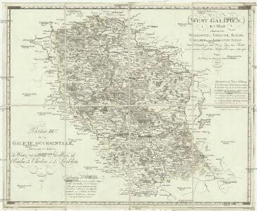
West Galizien
Chełm-oblast (Polsko) Müller, Karl Benedict, Ant. Kunst und Industrie Comptoirs
West Galizien
Halič (Polsko a Ukrajina) Müller, Karl Benedict, Ant. im Verlage des Kunst und Industrie Comptoirs
West-Galizien
Chełm-oblast (Polsko) Müller, Karl Benedict, Ant. im Verlage des Kunst und Industrie Comptoirs
Religion and language maps of Lublin province, Poland no.08
1 : 750000 Religion and language maps of Lublin province, Poland. Religion map by gminas showing relative majorities according to figures of Warsaw Statistical Committee, 1909. Based on information strongly biassed against the Catholics. War Office
Religion and language maps of Lublin province, Poland no.01
1 : 750000 Religion and language maps of Lublin province, Poland. Religion map by gminas showing most probable boundaries (based on information partly biassed against the Catholics). In this map Jews and Protestants are ignored. War Office
Religion and language maps of Lublin province, Poland no.02
1 : 750000 Religion and language maps of Lublin province, Poland. Language map by powiats from Russian census of 1897. War Office
Religion and language maps of Lublin province, Poland no.04
1 : 750000 Religion and language maps of Lublin province, Poland. Religion map by gminas comparing different authorities. Based on information partly biassed against the Catholics. In this map Jews and Protestants are ignored. War Office
Religion and language maps of Lublin province, Poland no.9
1 : 750000 Religion and language maps of Lublin province, Poland. Map showing Jews according to gminas. Based on figures of Warsaw Statistical Committee, 1909. War Office
Religion and language maps of Lublin province, Poland no.03
1 : 750000 Religion and language maps of Lublin province, Poland. Religion map by powiats from Dziewulski (1906). War Office
Religion and language maps of Lublin province, Poland no.06
1 : 750000 Religion and language maps of Lublin province, Poland. Religion map by gminas showing absolute majorities. Based on information strongly biassed against the Catholics. War Office
Religion and language maps of Lublin province, Poland no.07
1 : 750000 Religion and language maps of Lublin province, Poland. Religion map by gminas showing relative majorities according to figures of Dziewulski, 1906. Based on information partly biassed against the Catholics. In the district west of the Government of Chelm the Jews are in this map reckoned as Poles. War Office
Religion and language maps of Lublin province, Poland no.05
1 : 750000 Religion and language maps of Lublin province, Poland. Religion map by gminas showing absolute majorities according to figures of Dziewulski 1906 (based on information partly biassed against the Catholics). War Office
Religion and language maps of Lublin province, Poland no.10
1 : 750000 Religion and language maps of Lublin province, Poland. Map showing Protestants according to gminas. Based on figures of Warsaw Statistical Committee of 1909. War Office
Die Einnahme von Brest-Litowsk. (26. August 1915.)
Brest-Litowsk Weltkrieg <1914-1918>, Eroberung
Lublin 66, uit: Special-Karte von Mittel-Europa / nach amtlichen Quellen bearbeitet von W. Liebenow
1 : 300000 titelvariant: W. Liebenow's Mittel-Europa; Annotatie: Titel boven de bladen: W. Liebenow's Mittel-Europa Johannes Wilhelm Liebenow 1822-1897 Frankfurt a. M. : Ludwig Ravenstein
Siedlee 53, uit: Special-Karte von Mittel-Europa / nach amtlichen Quellen bearbeitet von W. Liebenow
1 : 300000 titelvariant: W. Liebenow's Mittel-Europa; Annotatie: Titel boven de bladen: W. Liebenow's Mittel-Europa Johannes Wilhelm Liebenow 1822-1897 Frankfurt a. M. : Ludwig Ravenstein
Warszawa, Brest-Litowsk, Radom, Lublin, Kielze, Tomaszów

Brzesc nad Bugiem

Sandomierz 80, uit: Special-Karte von Mittel-Europa / nach amtlichen Quellen bearbeitet von W. Liebenow
1 : 300000 titelvariant: W. Liebenow's Mittel-Europa; Annotatie: Titel boven de bladen: W. Liebenow's Mittel-Europa Johannes Wilhelm Liebenow 1822-1897 Frankfurt a. M. : Ludwig Ravenstein
Karte der Umgegend von Warschau
1 : 100000 Varšava-oblast (Polsko) Kartogr. Abteilung des Stellvertretenden Generalstabes des Armee
Mapa topograficzna okolic Warszawy
1 : 100000 Varšava-oblast (Polsko) Wojskowy instytut geograficzny
Lublin und Lubartów
1 : 75000 Lubartów (Polsko) Peja, G. K. u. k. Militärgeographisches Institut
Łuków und Mezyrecze
1 : 75000 Vogel, R. K. u. k. Militärgeographisches Institut
Iwangorod
1 : 75000 Dokaupil, R. K. u. k. Militärgeographisches Institut
Artileriekarte

Lomazy
1 : 75000 Cocron, H. K. u. k. Militärgeographisches Institut
Garwolin
1 : 75000 Mor Sunneg und Morberg, E. von K. u. k. Militärgeographisches Institut
Żelechów
1 : 75000 Richter, J. K. u. k. Militärgeographisches Institut
Karte des westlichen Russlands