Maps of Denmark

Post Karte von Daenemark nach Meilen
Dánsko Hallberg, von Santjohanser, N.
Denmark.
1 : 840000 Arrowsmith, John
Denmark.
1 : 1800000 Darton, William
Danemark.
1 : 1290000 Migeon, J.
Denmark, Alsace-Lorraine, Palatinate.
1 : 1500000 Andree, Richard; Times (London, England)
Dänemark mit Schleswig, Holstein
Dánsko
Daenemark, Schleswig-Holstein u. Lauenburg.
1 : 1000000 Stein, Christ. Gottfr. Dan.
Denmark, Sleswig, Holstein.
1 : 823680 Stanford, Edward
Daenemark, Island.
1 : 875000 Weiland, C. F. (Carl Ferdinand), d. 1847
Karte von dem Koenigreiche Daenemark
1 : 1000000 Dánsko Reilly, Franz Johann Josef von Franz Ioh. Ios. von Reilly
Denmark.
1 : 1800000 Mitchell, Samuel Augustus
Denmark.
1 : 1800000 Mitchell, Samuel Augustus
Denmark.
1 : 1840000 Tanner, Henry S.
Denmark.
1 : 1820000 Tanner, Henry S.
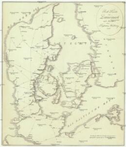
Kongeriget Danmark med Hertugdömmet Slesvig
1 : 480000 Olsen, O.N. ; Seehusen, P.J. Generalstab
Danmark
1 : 1000000 Bornholm (Dánsko) Geodaetisk institut
Danmark
1 : 1000000 Bornholm (Dánsko) Generalstabens topografiske afdeling
Denmark with Schleswig & Holstein.
1 : 1330560 Fullarton, A. & Co.
[DANIA REGNUM in quo sunt ducatus HOLSATIA et SLESVICUM INSULAE DANICAE et PROVINCIAE IUTIA, SCANIA, BLEKINGIA ET HALLANDIA]
1 : 1050000 Dánsko Wit, Frederick de F. de Wit
Regni Daniae in quo sunt ducatus Holsatia et Slesvicum insulae Danicae provinciae Iutia Scania Blekingia nova tabula
1 : 1100000 Dánsko Homann, Johann Baptist
Regni Daniae, in quo sunt ducatus Holsatia et Slesvicum, insulae Danicae, provinciae Iutia Scania Blekingia etc. nova tabula
1 : 1100000 Dánsko Homann, Johann Baptist â Io. Baptista Homanno
Regni Daniae, in quo sunt ducatus Holsatia et Slesvicum, insulae Danicae, provinciae Iutia Scania Blekingia etc. nova tabula
1 : 1100000 Dánsko Homann, Johann Baptist â Io. Baptista Homanno
REGNI DANIAE, in quo sunt DUCATUS HOLSATIA ET SLESVICUM, INSULAE DANICAE, PROVINCIA IUTIA SCANIA BLEKINGIA &c. Nova Tabula
1 : 1100000 Dánsko Homann, Johann Baptist a Io. Baptista Homanno
Regni Daniae
1 : 1129000 Dánsko Visscher, Nicolaus per Nicolaum Visscher
REGNI DANIAE, Novißima et accuratißima TABULA
1 : 1130000 Dánsko Visscher, Nicolaus per Nicolaum Visscher
Daniae Regnum [Karte], in: Gerardi Mercatoris et I. Hondii Newer Atlas, oder, Grosses Weltbuch, Bd. 1, S. 103.
1 Karte aus Atlas Mercator, Gerhard und Hondius, Jodocus Jansson, Jan
Dänemark und seine Nebenländer
Adolf Stieler's Handatlas über alle Theile der Erde und über das Weltgebäude Stieler, Adolf Justus Perthes
Pas-Caarte van't Schager-Rack, De Sondt en de Belt. [Karte], in: De Nieuwe Groote Vermeerderde Zee-Atlas ofte Water-Werelt, S. 21.
1 Karte aus Atlas Doncker, Hendrick
Daniae regnv[m]
1 Karte : Kupferdruck ; 36 x 43 cm Mercator; Hondius Henricus Hondius