Maps of Scandinavia

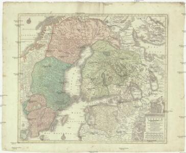
Nova mappa geographica Sueciae ac Gothiae regna ut et Finlandiae ducatum ac Lapponiam, cum provinciis minoribus, ob oculos ponens
1 : 3300000 Finsko Lotter, Tobias Conrad sumtibus Tobiae Conradi Lotteri
Regni Sueciae in omnes suas subjacentes provincias accurate divisi tabula generalis
1 : 3100000 baltské země Homann, Johann Baptist J. B. Homann
Svecia regnvm / avct. Andrea Bvræo Sveco
1 : 4140000 Annotatie: Kaart van Zweden, Finland en delen van Rusland en de Baltische Zee.; Origineel is Blad 140 in atlas factice; Met opdracht aan Carl (X) Gustavus, Koning van Zweden, door Joan Blaeu; Annotatie geografische gegevens: Met 6 schaalstokken Andreas Bureus 1571-1646 [Amsterdam : Joan Blaeu]
Sueciae magnae, totius orbis regni antiquissimi, hodierna in sex principales suas partes, Gothiam nempe, Sueciam propriam sive stricté Sumptam, Nordlandiam, Finniam, Ingriam, Livoniam
1 : 2700000 Finsko Valk, Gerhard Valk, Leonard per Ge.o et Le.o Valk
SVECIA | REGNVM
AVCT. ANDREA BVRÆO | SVECO. [Amsterdam : Joan Blaeu]
General Karte von Schweden und Norwegen
Norsko Sotzmann, Daniel Friedrich Erichsen im Verlag der K.K. priv. Schneider und Weigelschen Kunst- und Buchhandlung
Sueciae regnum cum vicinis regionibus
1 : 15900000 1 Karte : Kupferdruck ; 14 x 17 cm Weigel, Johann Christoph [Johann Christoph Weigel]
Das Koenigreich Schweden und Norwegen / verfertiget von Io. George Schreibern
1 : 12000000 1 Karte : Kupferdruck ; 15 x 20 cm, Bildgr. 16 x 24 cm Schreiber, Johann Georg [J. G. Schreiber]
Suecia Et Norvegia cum sonsiniis [Karte], in: Atlas, sive, Cosmographicae meditationes de fabrica mundi et fabricati figura, S. 128.
1 Karte aus Atlas Mercator, Gerhard
SYNOPSIS PLAGAE SEPTENTRIONALIS sive SUECIAE DANIAE ET NORWEGIAE REGN. accuratissime delineatum
1 : 4500000 Dánsko Seutter, Matthäus studio Matth. Seutteri
Synopsis plagae septemtrionalis sive Sueciae Daniae et Norwegiae regn. accuratissime delineatum
1 : 4500000 Dánsko Seutter, Matthäus Rogg, Gottfried studio Matth. Seutteri
Synopsis plagae septentrionalis sive Sueciae Daniae et Norwegiae regn. accuratissime delineatum
1 : 4500000 Dánsko Seutter, Matthäus studio Matth. Seutteri
Suecia Et Norvegia cum sonsiniis [Karte], in: Gerardi Mercatoris Atlas, sive, Cosmographicae meditationes de fabrica mundi et fabricati figura, S. 133.
1 Karte aus Atlas Mercator, Gerhard Montanus, Petrus
La Scandinavie où sont les royaumes de Suede, Danemark et Norwege
1 : 4000000 Jaillot, Alexis Hubert, 1632?-1712 chez Pierre Mortier
Sweden, Norway.
1 : 8600000 Arrowsmith, Aaron; Lewis, Samuel
Sweden, Norway.
1 : 8600000 Arrowsmith, Aaron; Lewis, Samuel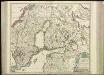
[69][69] Regni Sueciae ..., uit: Atlas sive Descriptio terrarum orbis
Annotatie: Gedigitaliseerde versie. Amsterdam. Heiloo : Picturae (vervaardiger), 2015. tiff-bestand. Gedigitaliseerd: 07-01-2015; Origineel: Universiteitsbibliotheek Vrije Universiteit (XL.05127.-) ; Netherlands; Titelpagina ontbreekt Wit, Frederik de Amsterdam : Frederick de Wit
Regnum Sueciae
Švédsko Lobeck, Tobias Lotter, Tobias Conrad Tobias Lobeck
Sweden.
1 : 6500000 Bowen, Emanuel

Regni Sueciae tabula generalis, divisa in Sueciae, Gotiaeque regna Finniae ducatum Lapponiam, Livoniam Ingriamque et in omnes subiacentes provincias
1 : 3250000 per F. de Wit Amstelodami Amstelodami : F. de Wit

Svecia et Norvegia cum confinijs
1 Karte : Kupferdruck ; 53 x 46 cm Mercator; Hondius Henricus Hondius
Regni Sueciae in omnes suas subjacentes provincias accurate divisi tabula generalis / edita a Ioh. B
1 : 3200000 1 Karte : Kupferdruck ; 47 x 55 cm Homann, Johann Baptist [Johann Baptist Homann]
Karte des Baltischen Meeres
Baltské moře (oblast) Artaria

Sweden & Norway.
1 : 7600000 Tanner, Henry S.
Sweden & Norway.
1 : 7603200 Tanner, Henry S.