Maps of Zeeland

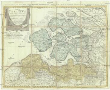
Charte von Zeeland nebst dem Antheil der General Staaten an Flandern, worauf der Lauf der Schelde von Antwerpen bis zu ihrem Ausfluß zu sehen ist
1 : 170000 Antverpy (Belgie) Güssefeld, Franz L. bey den Homannis Erben
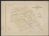
(No. I), uit: [Generale kaart van het Koningrijk Holland] / [onder leiding van C.R.T. Krayenhoff]
1 : 115200 Annotatie: Beschreven in: Topographische en militaire kaart van het Koningrijke der Nederlanden / J.A. van der Linden. - Bussum : Fibula-van Dishoeck, cop. 1973 (p. 12-13), en: Choro-topographische kaart der Noordelijke provinciën van het Koningrijk der Nederlanden / P.W. Geudeke. - Haarlem : Fibula-Van Dishoeck, [1979]; Voor aanwezige bladen zie overzichtsblad Krayenhoff, C. R. T. [Amsterdam : Dépôt Generaal van Oorlog]
(No. I), uit: Choro-topographische kaart der Noordelijke Provinciën van het Koningrijk der Nederlanden / uitgevoerd aan het Topographisch Bureau van dezen Staat, volgens het ontwerp, de geodesische en astronomische waarnemingen van Baron Kraijenhoff
1 : 115200 Annotatie: Gestempeld r.o. in rood: AVO (=Archief van Oorlog); Lit.: J.A. van der Linden, Topographische en militaire kaart van het Koningrijk der Nederlanden. Bussum 1973. p. 9-16 & E. ten Brink, De grote kaart van Krayenhoff, speciaal p. 38-39; Op de bladwijzer staat de Hoofddriehoeksmeting aangegeven met de Alphabetische tafel der breedte en lengte van de standplaatsen; Annotatie geografische gegevens: Schaalstok van 27,77 Mylen (Kilomètres) of 7380 Rh. Roeden of 5 Uren (=23,7 cm), op schaal: 800 Rl. Roeden op den Rh. Duim of van 1,152 Myl (Kilomètre) op den Duim (Centimètre); Legenda r.o. op blad VII Topographisch Bureau, Den Haag; Archief van Oorlog, Den Haag ['s-Gravenhage : Topographisch Bureau, Archief van Oorlog]
Zeelandia Comitatus.
1 : 280000 [Amsterdam] : [Joannes Janssonius]
Zeelandia Comitatus. [Karte], in: Gerardi Mercatoris et I. Hondii Newer Atlas, oder, Grosses Weltbuch, Bd. 1, S. 459.
1 Karte aus Atlas Mercator, Gerhard und Hondius, Jodocus Jansson, Jan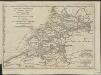
Esquisse géographique du cours de l'Escaut d'Anvers à la mer, de ses bouches, et de ses communications avec l'intérieur de la Flandre, de la Zelande et de la Hollande : Les Isles de Walcheren, Wolfertsdyk etc]
1 : 510000 par L.S. de La Rochette gravé par J. Turpin à La Haye. [London] : [Faden]
No. III, uit: Choro-topographische kaart der Noordelijke Provincien van het Koningrijk der Nederlanden / uitgevoerd aan het Topographisch Bureau van dezen staat ; volgens het ontwerp, de geodetische en astronomische waarnemingen van den Luitenant Generaal Baron Krayenhoff
1 : 115200 titelvariant: Generale kaart van het Koningrijk Holland; Chorographische kaart van Holland vereenigd met het Fransche Rijk; Carte chorographique des Departemens de la Hollande; Annotatie: Voor aanwezige bladen zie overzichtsblad; Blad Noord-Brabant ontbreekt Krayenhoff, C. R. T.; Ministerie van Oorlog. Topographisch Bureau ['s-Gravenhage : Archief van Oorlog]
Zeelandia comitatus.
1 : 400000 [Frankfurt am Main] : [Caspar Merian]
Zeelandia Comitauts. [Karte], in: Novus atlas absolutissimus, Bd. 3, S. 188.
1 Karte aus Atlas Janssonius Offizin
ZEELANDIA Comitatus
[Amsterdam : Joan Blaeu]
Zeelandia Comitatus. [Karte], in: Theatrum orbis terrarum, sive, Atlas novus, Bd. 1, S. 437.
1 Karte aus Atlas Blaeu, Joan Blaeu, Willem Janszoon
Zeelandia Comitatus
1 : 700000 Petrus Kaerius Flander caelavit aetatis 75. [Amsterdam] : [Johannes Janssonius]
ZEELANDIA Comitatus
[Amsterdam : Joan Blaeu]
Zeelandia Comitatus. [Karte], in: Novus Atlas, das ist, Weltbeschreibung, Bd. 1, S. 405.
1 Karte aus Atlas Blaeu, Joan Blaeu, Willem Janszoon
Zeelandia Comitatus. [Karte], in: Le théâtre du monde, ou, Nouvel atlas contenant les chartes et descriptions de tous les païs de la terre, Bd. 1, S. 436.
1 Karte aus Atlas Blaeu, Willem Janszoon und Blaeu, Joan Blaeu, Willem Janszoon
Zeelandia comitatus
1 : 270000 Cornelis Danckerts excudit. [Amsterdam] : Cornelis Danckerts excudit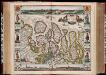
Comitatus Zelandiae nova descriptio anno 1657 / [Nicolaes Visscher]
1 : 200000 Annotatie: Origineel is Blad 47 in atlas factice; Met panorama's van Middelburg, Vlissingen en Zierikzee; Met kostuurfiguren naast de kaart; Annotatie geografische gegevens: West boven Visscher, Nicolaes (1618-1679) [Amsterdam : N. Visscher excudebat]
Naeukeurige nieuwe land-caert des graefschaps Zeeland.
1 : 170000 Tot Middelburgh : by Johannes Meertens, en is tot Amsterdam te bekomen by Abraham van Someren
Abris der Schelde, soweit sie schiffbar ist, von Antwerpen bis an die Nord-See
1 : 550000 Math. Pock geometra sc. Salisburgi. Salzburg : Lor. Hübner
Vlaanderen en Zeeland zoo als het was ten tijde van Guido van Dampier Graave van Vlaanderen Anno Christi MCCLXXIV.
1 : 160000 [S.l.] : [s.n.]
A new map of Zealand : with the rivers Schelde, part of Holland, Flanders & Brabant, shewing the situation of the Schelde.
1 : 245000 London : Jno. Stockdale Picadilly
Naeukeurige nieuwe land-caert des graefschaps Zeeland.
1 : 160000 Te Leide : by Christiaen Vermey
Neuer Plan von den Lauf der Schiffbaren Schelde von Antwerpen durch Holländisch Seeland, bis zu deren Mündung an der Nord-See
1 : 550000 I. Berlia sc. Prag : aus der von Schönfeldischen Officin
A new map of Zealand : with the rivers Schelde, part of Holland, Flanders & Brabant, shewing the situation of the present dispute between the Emperor and the Dutch.
1 : 245000 London : Jno. Stockdale Picadilly
Antwerpen 68, uit: Special-Karte von Mittel-Europa / nach amtlichen Quellen bearbeitet von W. Liebenow
1 : 300000 titelvariant: W. Liebenow's Mittel-Europa; Annotatie: Titel boven de bladen: W. Liebenow's Mittel-Europa Johannes Wilhelm Liebenow 1822-1897 Frankfurt a. M. : Ludwig Ravenstein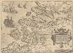
Zelandicarum Insularum Exactissima Et Nova Descriptio [Karte], in: Theatrum orbis terrarum, S. 189.
1 Karte aus Atlas Ortelius, Abraham Vrients, Jan Baptista
Antwerpen 68, uit: [W. Liebenow's Special-Karte von Mittel-Europa]
1 : 300000 titelvariant: W. Liebenow's Mittel-Europa; Annotatie: Titel boven de bladen: W. Liebenow's Mittel-Europa Johannes Wilhelm Liebenow 1822-1897 Hannover : Hermann Oppermann
Neuer Plan von den Lauf der Schiffbaren Schelde, von Antwerpen durch Holländisch Seeland, bis zu deren Mündung an der Nord See
1 : 560000 Nizozemsko Berka, Jan aus der von Schönfeldischen Officin
Neuer Plan von den Lauf der Schiffbaren Schelde, von Antwerpen durch Holländisch Seeland, bis zu deren Mündung an der Nord See
1 : 560000 Nizozemsko Berka, Jan aus der von Schönfeldischen Officin