Maps of Trentino-Alto Adige

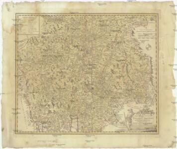
Tyrolis pars meridionalis
1 : 218000 Trident (Itálie : provincie) Spergs, Ioseph de Homannianis Hered.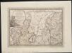
Lo Stato Veneto da terra diviso nelle sue provincie : prima parte che comprende Il Bergamasco Il Cremasco Il Feltrino Il Bellunese e porzioni del Bresciano Veronese Vicentino Padovano Dogado Trevisano e Friuli
1 : 1
Trient
1 : 200000 1 Karte entworfen und bearbeitet von Woerl ; in Stein gestochen unter seiner Leitung ; Lithographie von B. Herder Herder, Freiburg im Breisgau
Territorio Di Trento [Karte], in: Le théâtre du monde, ou, Nouvel atlas contenant les chartes et descriptions de tous les païs de la terre, Bd. 3, S. 162.
1 Karte aus Atlas Blaeu, Willem Janszoon und Blaeu, Joan Blaeu, Willem Janszoon
Territorium Tridentinum [Karte], in: Novus atlas absolutissimus, Bd. 2, S. 223.
1 Karte aus Atlas Janssonius Offizin
Territorio Di Trento [Karte], in: Novus Atlas, das ist, Weltbeschreibung, Bd. 3, S. 154.
1 Karte aus Atlas Blaeu, Joan Blaeu, Willem Janszoon
Territorio Di Trento [Karte], in: Theatrum orbis terrarum, sive, Atlas novus, Bd. 3, S. 134.
1 Karte aus Atlas Blaeu, Joan Blaeu, Willem Janszoon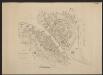
Territorium Tridentinum [Karte], in: Gerardi Mercatoris et I. Hondii Newer Atlas, oder, Grosses Weltbuch, Bd. 2, S. 228.
1 Karte aus Atlas Mercator, Gerhard und Hondius, Jodocus Jansson, Jan
TERRITORIO | DI | TRENTO.
Excudebat | Guiljelmus Blaeu.

Carte de la Suisse avec les plans des cheflieux des 22 cantons
1 : 200000 1 Karte auf 8 Bl. dessinée et publié par Henri Keller ; Lithogr. von J. Schweizer = Charte der Schweiz mit den Grundrissen der Hauptorte der 22 Cantone Keller, Zürich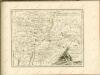

Distanzenkarte von der Schweiz
1 : 200000 1 Karte in 8 Teilen nach den besten Hülfsquellen bearb. von R. Huber Wagner, Bern
Wandkarte der Schweiz
1 : 200000 1 Karte auf 8 Blättern J.M. Ziegler Wurster, Winterthur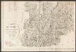
Carte du Tyrol
1 : 150000 Südwest-Blatt Anich, Peter par le Dépôt Général de la Guerre
Carta geologica delle provinicie Lombarde
1 : 172800 Ostblatt Curioni, G. Hoepli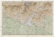
Karte der Lombardischen und Süd-Tiroler-Alpen
1 : 250000 Ravenstein, Ludwig Ludwig Ravenstein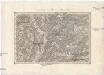
Umgebungen von Bolzen und Neumarkt
1 : 144000 Bolzano (Itálie : provincie) Stein, Carl K. u. k. Militärgeographisches Institut
Schulwandkarte zur Geschichte der Schweiz
1 : 180000 Südost-Blatt Oechsli, Wilhelm ; Baldamus, Alfred Kartograph. Verlagsanstalt von Georg Lang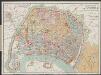
Carte Particuliere Du Bressan Faisant Partie des Etats dela Republique De Venise Leveé Par Ordre Exprès á L'Usage des Armées En Italie &c. [Karte], in: Atlas nouveau, contenant toutes les parties du monde [...], Bd. 2, S. 166.
1 Karte aus Atlas Sanson, Nicolas Jaillot, Alexis Hubert und Mortier, Pieter
Carte particulière du Bressan faisant partie des états de la république de Venise : levée par ordre exprès à l'usage des armées en Italie &c
1 : 220000 par le Sr Sanson, Geograph. du Roy A Amsterdam : chez Pierre Mortier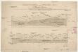
Heerstrasse über das Stilfser Joch oder die Wormses Strasse
Inst. Bibl.
Carte Tres Particuliere du Brassan Faisant partie des Etats de la Republique de Venise
1 : 370000 Mollova mapová sbírka Nolin, Jean-Baptiste Nolin, Jean Baptiste
Carte du Tyrol
1 : 150000 West-Blatt Anich, Peter par le Dépôt Général de la Guerre

Schulwandkarte zur Geschichte der Schweiz
1 : 180000 1 Karte auf 6 Bl. bearbeitet v. W. Oechsli u. A. Baldamus ; gezeichnet von Ed. Gaebler Kartograph. Verlagsanstalt von Georg Lang, Leipzig
Italy: Trentino Orientale
Trentino Orientale: Enemy's organisation affecting British front. May 1918. From a collection of maps of the theatre of war in Italy, 1917-18. War Office
Süd. Oetzthaler- und Ortler Alpen, Presanella Gruppe
1 : 130000 Ortles (Itálie : pohoří) Maschek, Rudolf Meurer, Julius Artaria