Maps of Durlach

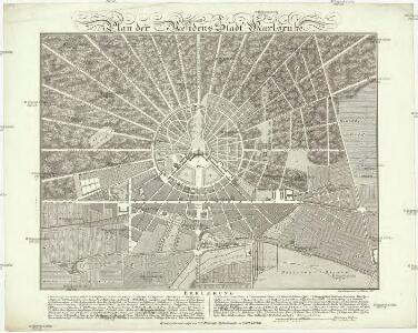
Plan der Residenz-Stadt Karlsruhe
1 : 4500 Karlsruhe (Německo) Börner, G. C.F. Müller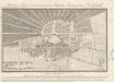
Situations Plan von der Grosherzoglich Badischen Residenz Stadt Karlsruhe
Weinbrenner, Friedrich
Accurater Prospect der Hoch-Fürstl. Margraff Baaden Durlachischen neu erbauten verwunderungs wündige[n] Residenz Stadt Carlsruhe
Karlsruhe (Německo) Seutter, Matthäus M. Seutter
Plan von Carlsruhe
1 : 14000 F. Biberstein fct. Karlsruhe : Lith. Artistisches Institut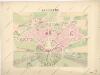
Karlsruhe

Novveav plan du Carolsrvhe sur deux feuilles, 3
1 Blatt : Homännische Erben
Novveav plan du Carolsrvhe sur deux feuilles, 2
1 Blatt : Homännische Erben
Novveav plan du Carolsrvhe sur deux feuilles, 1
1 Blatt : Homännische Erben
Karlsruhe
1 : 20000 Karlsruhe (Německo) Bibliographisches Institut
Topographische Karte von der Grosh. Haupt- u. Residenz-Stadt Carlsruhe mit ihren Umgebungen
1 : 20000 Lorenz, Wilhelm Wehrle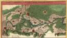
Vorstellung des Campements der Kayserl. u. Reichs-Armee zu Bruchsal mit denen Inondationen u. neuen Linien 1735 in denen Gegenden von Ettlingen bis Langenbruck
1 : 45000 Mollova mapová sbírka Riecke, Gustav Friedrich Homann, Johann Baptista - dědici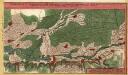
Vorstellung des Campements der Kayserl. u. Reichs-Armee zu Bruchsal mit denen Inondationen u. neuen Linien 1735 in denen Gegenden von Ettlingen bis Langenbruck
1 : 45000 Mollova mapová sbírka Riecke, Gustav Friedrich Homann, Johann Baptista - dědici
Meßtischblatt 51 : Carlsruhe. 1876
1 : 250000 Carlsruhe. - 1:25000. - Leipzig: Giesecke & Devrient, 1876. - 1 Kt.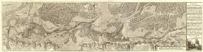
Carte von der Innondation Von Ettlingen biss zu dem Kislauer Schlosse
1 : 35000 Mollova mapová sbírka Riecke, Gustav Friedrich Bodenehr, Gabriel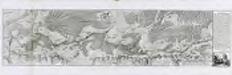
Carte von der Innondation von Ettlingen biss zu dem Kislauer Schlosse
1 Karte auf 2 Blatt : Kupferdruck ; 23 x 94 cm Riecke; Bodenehr
[Philipsbourg]
1 Blatt : 60 x 91 cm s.n.
Vorstellung des Campements der kayserl. u. Reichs-Armee zu Bruchsal
1 Karte auf 2 Blättern : Kupferdruck ; je 23 x 44 cm Riecke Homännische Erben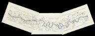
[Lauf des Rheins von Neuburg bis unterhalb Mannheim im Anfange des Jahres 1837] : Tab. 1: Hydrographische Charte vom Lauf des Rheins v. Neuburg bis Sondernheim die im Jahre 1817 angefangen Rectification desselben enthaltend. 2: Hydrographische Carte vom Lauf des Rheins von Sondernheim bis Otterstatt mit Rücksicht auf die Rectification desselben . 3: Hydrographische Carte vom Lauf des Rheins mit Rücksicht auf die Rectification desselben : Distrikte v. Waldsee bis an die Hessischen Grenze
1 : 80000 [S.l.] : Grosh. Bad. Landw. Wochenblatt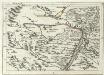
Geographica Provinciarum Sveviae Descriptio =
Mollova mapová sbírka Hurter, Johann Christoph Bodenehr, Gabriel
Le Flambeau de la Guerre Allumee au Rhin
Mollova mapová sbírka Delisle, Guillaume Schenk, Peter II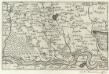
Landau mitt umbliegenden dörfferen und Stätten
1 : 170000 Mollova mapová sbírka Person, Nikolaus Person, Nicolas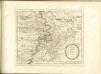

Der Pfinz und Enz Kreis im Grossherzogthum Baden
1 : 200000 Bádensko (Německo) Krauth Wolff, F. C.F. Müllerschen Buchhandlung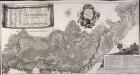
Accurate Special-Charte der Gegend des Rheins, von Ettlingen, Carls Ruhe, Philippsburg, Bruchsal, bis Mannheim, etc. Entworffen
Riecke, Gustav Friedrich; Ostertag, Heinrich Jonas; Cöntgen, Bartolomäus Anton Brönner
Alasatia superior et inferior III. tabulis delineata, 3
1 Blatt : 62 x 59 cm s.n.
Carte Particuliere de Pays qui sont situéz entre le Rhein, la Saare, la Moselle, et la Basse Alsace
1 : 150000 Mollova mapová sbírka Jaillot, Alexis-Hubert Jaillot, Alexis Hubert
Exact und Gantz accurater Plan
1 : 570000 Mollova mapová sbírka Geyer, Friedrich W. Berndt, Johann Christoph Geyer, Friedrich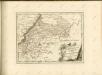

Suevia Universa
1 : 170000 Mollova mapová sbírka Michal, Jacques de Seutter, Matthäus Seutter, Matthäus