Maps of Baden-Württemberg

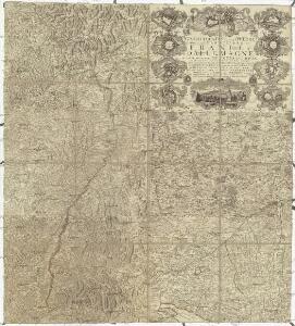
Grand theatre de la guerre sur les frontieres de France & d' Allemagne ou carte nouvelle du cours du Rhin et des pais circonvoisins contenant la Haute & Basse Alsace & le Palatinat & les electorats de Mayence, de Treves & une partie de Cologne de Hesse, de Franconie, de Baviere, le cercle de Souable le duché de Wurtenberg, de Brisgaw, de Bade, de Suntgaw & c. & c. & c
Francie Delisle, Guillaume Jean Covens & Corneille Mortier
Übersichtskarte von Mittel - Europa

Grand Theatre de la Guerre sur les Frontieres de France & d'Allemagne
1 : 240000 Mollova mapová sbírka Delisle, Guillaume Ottens, Josua
Totius fluminis Rheni novissima descriptio
Rýn, řeka-oblast Wit, Frederick de Frederick de Witt
Geognostische Karte von Württemberg, Baden und Hohenzollern
1 : 700000 Bach, Carl Philipp Heinrich Verlag der G. Ebner'schen Kunsthandlung
Palatinat du Rhein, Alsace, et Partie de Souabe de Franconie &c.
1 : 870000 Mollova mapová sbírka Sanson, Nicolas Cordier, Robert Sanson, Nicolas
Grossherzogthum Baden
1 : 824000 Bádensko (Německo) Martin Gleditsch
Mainz, Nürnberg, Strassburg, Ulm
1 : 750000 Hannover (Německo : oblast) Budik, A. K. u. k. Militärgeographisches Institut
Mainz, Nürnberg, Strassburg, Ulm
1 : 750000 Hannover (Německo : oblast) K. k. militär-geographisches Institut
Bayern, Wurtemberg, Baden, Hohenzollern.
1 : 1500000 Meyer, Joseph, 1796-1856
Charte Von Mosel Saar Neccar-Rhein- und Mayn-Strom
1 : 780000 Mollova mapová sbírka Riegel, Christoph Riegel, Christoph
Sveviae utriusque cum Germanicæ tum Rheticæ celebratissimis vrbibus
1 Karte : Kupferdruck ; 20 x 22 cm, Bildgrösse 21 x 29 cm Seltzlin; Quad; Bussemacher excudit Johan Buchsemecher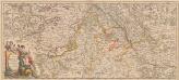
Totius Fluminis Rheni Novissima Descriptio [Karte, Teil 1], in: Novus atlas absolutissimus, Bd. 2, S. 150.
1 Karte aus Atlas Janssonius Offizin
Abriss des Reinstroms
1 : 870000 Mollova mapová sbírka
1:500,000 Europe (Air) G.S.G.S. No. 4072, Strasbourg
Sheet NE48-6 from the map series: 1:500,000 Europe (Air) G.S.G.S. No. 4072.
Circulus Suevicus
1 Karte : Kupferdruck ; 48 x 56 cm Lotter Tobias Konrad Lotter
Nördliche Fortsetzung des Rhein von Oppenheim bis Köln
Hand-Atlas über alle Theile der Erde nach dem neuesten Zustande und über das Weltgebäude Stieler, Adolf bei Justus Perthes
Nördliche Fortsetzung des Rhein von Oppenheim bis Köln
Hand-Atlas über alle Theile der Erde nach dem neuesten Zustande und über das Weltgebäude Stieler, Adolf bei Justus Perthes
Charte von dem Königreiche Wirtemberg und dem Grossherzogthume Baaden
Grand theatre de la guerre, frontieres de France, d'Allemagne.
L'Isle, Guillaume de, 1675-1726
Composite: Rhin.
1 : 256000 L'Isle, Guillaume de, 1675-1726
Circulus Svevicus
1 Karte : Kupferdruck ; 46 x 65 cm Kraus; Wagner; Wille sumtibus Matthæi Wagner
[Southwest Germany]
1 : 1400000 [S.l. : s.n.]
Haut, Bas Rhin.
1 : 640000 Robert de Vaugondy, Gilles, 1688-1766
Hessen-Nassau, Groszherzogtum Hessen und Furstentum Waldeck
1 : 500000 Scobel, Albert
Tabula Nova Particularis Provincie Rheni Superioris [Karte], in: Claudii Ptolemei viri Alexandrini mathematice discipline philosophi doctissimi geographie opus [...], S. 278.
1 Karte aus Atlas Waldseemüller, Martin [und Ptolemaeus, Claudius] Übelin, Georg
Circulus Sueviæ
1 Karte : Kupferdruck ; 47 x 54 cm Homann Johann Baptist Homann
Circulus Suevicus in quo sunt ducatus Wirtenbergensis
1 Karte : Kupferdruck ; 48 x 57 cm Danckerts Theodorus Danckerts