Maps of okres Bruntál

[Circuli Olomucensis pars borealis]
1 : 150000 Morava (Česko) Müller, Johann Christoph
Circuli Olomucensis pars borealis
1 : 150000 Morava (Česko) Müller, Johann Christoph
Olmütz 105, uit: Special-Karte von Mittel-Europa / nach amtlichen Quellen bearbeitet von W. Liebenow
1 : 300000 titelvariant: W. Liebenow's Mittel-Europa; Annotatie: Titel boven de bladen: W. Liebenow's Mittel-Europa Johannes Wilhelm Liebenow 1822-1897 Frankfurt a. M. : Ludwig Ravenstein
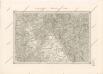
Marchionatus Moraviae Circulus Olomucensis pars Borealis

Circuli Olumucensis pars Borealis /
1 : 233000 Mollova mapová sbírka Müller, Johann Christoph Homann, Johann Baptista - dědici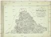
Uebersichts-Karte vom Olmützer Kreise des Makgrafthumes Maehren
Olomouc-oblast (Česko) Rheinfeld, Carl Myrbach von
Jeseníky

Jeseníky

Jeseníky

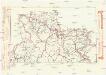
Generální mapa okresních hejtmanství
Komunikační mapa země Moravskoslezské
1 : 100000 Jeseník (Česko : oblast) Morslez. zem. výbor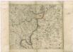
Müllerova mapa Čech
1 : 132000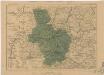
Generální mapa okresních hejtmanství

Freiwaldeau.
from Spezialkarte der osterreichisch-ungarischen Monarchie.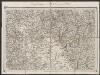
Umgebungen von Schönberg und Littau
1 : 144000 K.K. Militärisches Geographisches Institut
Reymann ́s Special Karte 190 Troppau
Special - Karte der Markgrafschaft Maehren und des Herzogthums Schlesien
II. vojenské mapování 4
1 : 144000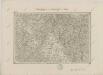
II. vojenské mapování 4
1 : 144000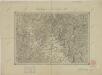
II. vojenské mapování 4
1 : 144000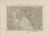
II. vojenské mapování 4
1 : 144000
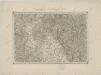
Mappa geographica regni Bohemiae in duodecim circuloc divisae ... Sectio. XV.
II. vojenské mapování 1
1 : 144000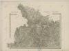
II. vojenské mapování 1
1 : 144000
Mhr. Neustadt und Mgr. Schonberg.
from Spezialkarte der osterreichisch-ungarischen Monarchie.
Karte des politischen Bezirkes Freudenthal

Umgebungen von Friedberg und Freywaldau
1 : 144000 K.K. Militärisches Geographisches Institut
Komunikační mapa země Moravskoslezské
1 : 100000 Olomouc (Česko : oblast) Morslez. zem. výbor
II. vojenské mapování - speciální mapa Markrabství moravského s částí Slezského vévodství 1
1 : 144000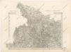
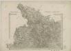
![[Circuli Olomucensis pars borealis]](https://images-2.georeferencer.com/images/iiif/317952987456/full/,300/0/native.jpg)

