Maps of Antwerpen

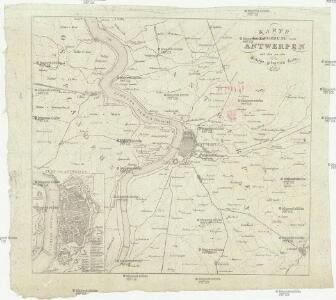
Karte der Umgebung von Antwerpen
Antverpy (Belgie)
Carte des environs d'Anvers
1 : 100000 Dordt : by Steuerwald & Co. ; Breda : bij Broese & Co.
55 Hulst, uit: Topographische en militaire kaart van het Koningrijk der Nederlanden / vervaardigd door de officieren van den Generale Staf ; en gegraveerd op het Topographisch Bureau, van het Ministerie van Oorlog
1 : 50000 titelvariant: TMK; Annotatie: Met bladwijzer op schaal 1:600.000. - 1915; Met Verklaring van de topographische en militaire kaart van het Koninkrijk der Nederlanden. - 1910; Bd. 1: titelblad, bladwijzer, verklaring, bladen 1 t/m 32; Bd. 2: bladen 33 t/m 62 Generale Staf, Nederland; Ministerie van Oorlog. Topographisch Bureau ['s-Gravenhage : Ministerie van Oorlog]
Plan officiel des travaux du siége de la citadelle d'Anvers exécutés par l'armée francaise en 1832
1 : 5300 Antverpy (Belgie) Tardieu, Ambroise Anselin Ambroise Tardieu
Marchionatus Sacri Romani Imperii : Nobilißimo, Amplißimo, Prudentißimoq[ue] Senatuj Urbis Antverpiæ, nec non Marchionatus Sacri Imperij, Viris Consultissimis Sapientissimisq[ue]
Visscher, Nicolaes, 1618-1679 Nicolaus Jansenius Piscator
Marchionatus Sacri Romani Imperii. [Karte], in: Novus atlas absolutissimus, Bd. 3, S. 55.
1 Karte aus Atlas Janssonius Offizin
Plan der Schelde van boven Antwerpen tot aan het dorp Doel: met de positie onzer scheepsmagt by de hervatting der vyandelykheden tegen de Belgen, op den 3den augustus 1831, enz.
1 : 29000 zamengesteld door M.F. Courier dit Dubekart gegraveerd door W.C. van Baarsel
[Plan du port d'Anvers]
1 : 21000 [Anvers] : [éditeur inconnu]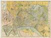
[Kaart], uit: Nieuw plan van Antwerpen, voorsteden en dokken : met aanduiding der kaainummers
1 : 12500 titelvariant: Antwerpen; Annotatie: Omslagtitel: Antwerpen : gids Brabo ... Antwerpen : Stappaers
Plan parcellaire de la commune de Calloo : avec les mutations
1 : 5000 Royal Library of Belgium Map Room Popp, Philippe Christian (1805-1879) Popp, Philippe Christian (1805-1879)
Plan parcellaire de la commune de Melsele : avec les mutations
1 : 5000 Royal Library of Belgium Map Room Popp, Philippe Christian (1805-1879) Popp, Philippe Christian (1805-1879)
Antwerpen
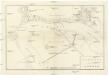
Position devant Anvers
Antverpy (Belgie)
Plan de la ville d'Anvers et ses environs
1 : 9300 Richard Huybrechts & Cie. Editeurs chez Rich[ar]d Huybrechts & cie. editeurs
Marchionatus Sacri Romani Imperii
1 : 21000 C.J. Visscher excudebat [Amsterdam] : nunc apud Petrum Schenk Junior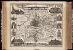
Marchionatus Sacri Romani Imperii / [C.J. Visscher]
1 : 60000 Annotatie: Origineel is Blad 44 in atlas factice; Met kaartje van de omgeving, afbeeldingen van de voornaamste gebouwen en 3 panorama's; Annotatie geografische gegevens: Oost boven Visscher, Claes Jansz. [Amsterdam : C.J. Visscher excudebat]
Nouveau plan de la ville d'Anvers / dressé par A. Scheepers
1 : 10000 Scheepers, A.
Plan parcellaire de la commune de Schooten : avec les mutations
1 : 5000 Royal Library of Belgium Map Room Popp, Philippe Christian (1805-1879) Popp, Philippe Christian (1805-1879)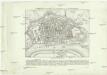
Plan der Stadt und Citadelle von Antwerpen
Antverpy (Belgie) Tardieu, Auguste Ambroise Industrie Comptoir
Neuester Plan der Stadt u. Citadelle nebst der Umgegend von Antwerpen und der Lage der fr. Batterien
Antverpy (Belgie) Wappen C. Henning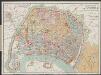
Plan-guide d'Anvers
1 : 12500 Librairie Ackermann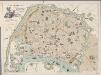
[Recto], uit: Plan instantané de la ville d'Anvers : indiquant les principaux monuments en relief, le tracé des tramways, les nouveaux quais, hangars, etc., etc. / dressé par E.V.D.H.
1 : 11600 E.V.D.H. Anvers : Huybrechts
Plan parcellaire de la commune de Bouchout (lez Lierre) : avec les mutations
1 : 5000 Royal Library of Belgium Map Room Popp, Philippe Christian (1805-1879) Popp, Philippe Christian (1805-1879)
Plan parcellaire de la commune de Zwyndrecht : avec les mutations
1 : 5000 Royal Library of Belgium Map Room Popp, Philippe Christian (1805-1879) Popp, Philippe Christian (1805-1879)
Plan parcellaire de la commune de Beveren Waes : avec les mutations
1 : 5000 Royal Library of Belgium Map Room Popp, Philippe Christian (1805-1879) Popp, Philippe Christian (1805-1879)
Plan parcellaire de la commune de Wilryck : avec les mutations
1 : 5000 Royal Library of Belgium Map Room Popp, Philippe Christian (1805-1879) Popp, Philippe Christian (1805-1879)
Plan parcellaire de la commune de Oorderen : avec les mutations
1 : 5000 Royal Library of Belgium Map Room Popp, Philippe Christian (1805-1879) Popp, Philippe Christian (1805-1879)
Plan parcellaire de la commune de Cruybeke : avec les mutations
1 : 5000 Royal Library of Belgium Map Room Popp, Philippe Christian (1805-1879) Popp, Philippe Christian (1805-1879)
Plan parcellaire de la commune de Austruweel : avec les mutations
1 : 5000 Royal Library of Belgium Map Room Popp, Philippe Christian (1805-1879) Hauer, Daniel Adam, Popp, Philippe Christian (1805-1879)