Maps of South Africa

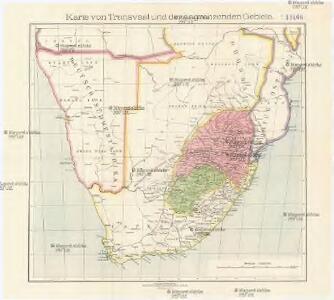
Karte von Transvaal und der angrenzenden Gebiete
1 : 5000000 Afrika jižní Dietrich Reimer (Ernst Vohsen)
Politisch - militärische Karte von Süd-Afrika
South Africa.
1 : 5000000 John Bartholomew and Son
Politisch-militärische Karte von Süd-Afrika : zur Veranschaulichung der Kämpfe zwischen Buren und Engländern bis zur Gegenwart / Paul Langhans
1 : 4000000 Langhans, Paul Gotha : Justus Perthes
[LL.04716gk: 591/od/1899], uit: Kaart van Zuid-Afrika : (Zuid-Afrikaansche Republiek, Oranje-Vrijstaat en aangrenzend gebied)
1 : 5600000 Amsterdam [etc.] : J.H. de Bussy
[LL.04752gk: 591/od/1899] [Recto], uit: Kaart van Zuid-Afrika : (Zuid-Afrikaansche Republiek, Oranje-Vrijstaat en aangrenzend gebied)
1 : 5600000 Amsterdam [etc.] : J.H. de Bussy
[LL.04751gk: 591/od/1899] [Recto], uit: Kaart van Zuid-Afrika : (Zuid-Afrikaansche Republiek, Oranje-Vrijstaat en aangrenzend gebied)
1 : 5600000 Amsterdam [etc.] : J.H. de Bussy
[Kaart], uit: Karte des Afrikander-Aufstandes im Kaplande und des Angriffskrieges der Buren / Paul Langhans
1 : 4000000 titelvariant: Karte des Afrikander-Aufstandes im Kaplande; Annotatie: Omslagtitel: Karte des Afrikander-Aufstandes im Kaplande; Met portret van Christian de Wet Langhans, Paul Gotha : Perthes
Karte des Afrikander-Aufstandes im Kaplande und des Angriffskrieges der Buren
1 : 4000000 Langhans, Paul Perthes
Itinéraire de Mr et Mme Coillard du Pays des Bassoutos au Zambèze
1 : 12100000 [Paris] : Société de géographie
La Basse Guinée, contenant les royaumes de Loango, de Congo, d'Angola et de Benguela, avec la Cafrérie occidentale et la méridionale, ou le pays des Hotentots
1 : 9600000 Angola Bonne, Rigobert André
Das Capland nebst den süd-afrikanischen Freistaaten un dem Gebiet der Hottentotten & Kaffern.
A land divided against itself.A map of South Africa showing the African Homelands and some of the mass removals of people which have taken place,..
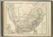
South Africa.
1 : 3817440 Johnston, W. & A.K.
Zuid-Afrika
1 : 10000000 steendruk van P.W.M. Trap [Amsterdam] : [s.n.]
Spezial - karte von AfricaSektion Capland (9)
1 : 4000000 1 full d'1 mapa en 10 fulls i estoig Hermann Habenicht; Justus Perthes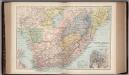
South Africa 40
1 : 4200000 Appleton, D. & Co.
South Africa.
1 : 10080000 Peterson, Augusts
Das Capland nebst den Süd-Afrikanischen Freistaaten und dem Gebiet der Hottentotten & Kaffern
Handatlas über alle Theile der Erde und über das Weltgebäude Stieler, Adolf Justus Perthes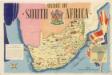
Union of South Afrika
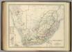
South Africa.
1 : 3817440 Johnston, Alexander Keith
Das Capland nebst den Süd-Afrikanischen Freistaaten und dem Gebiet der Hottentotten & Kaffern
Hand-Atlas über alle Theile der Erde und über das Weltgebäude Stieler, Adolf Justus Perthes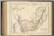
South Africa.
1 : 4118400 Fullarton, A. & Co.
[Süd-Afrika]
Hand-Atlas über alle Theile der Erde nach dem neuesten Zustande und über das Weltgebäude Stieler, Adolf bei Justus Perthes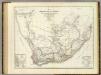
Sud. v. Africa.
1 : 3000000 Weiland, C. F. (Carl Ferdinand), d. 1847
Süd-Afrika
Hand-Atlas über alle Theile der Erde nach dem neuesten Zustande und über das Weltgebäude Stieler, Adolf bei Justus Perthes
Spezial-Karte von Afrika
1 : 4000000 Blatt 9 Habenicht, Hermann Perthes
Das Capland Nebst Den Sud-Afrikanischen Freistaaten.
1 : 5000000 Petermann, A.
Mission map of South Africa according to the map in Stieler's Atlas