Maps of Severno-Banatski

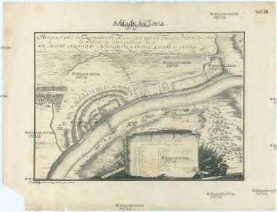
Schlacht bei Zenta
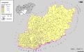
1 : 7000 Senta (Srbsko) K.k. Generalstabes
Bataille de Zenta
Nouvel atlas physique politique et historique de l'Empire ottoman et des états limitrophes en Europe, en Asie et en Afrique, en quarante feuilles Hellert, J.J. Bellizard, Dufour et Cie
Zenta und Ada.; Spezialkarte der osterreichisch-ungarischen Monarchie.
from Spezialkarte der osterreichisch-ungarischen Monarchie. Austro-Hungarian Monarchy. Militärgeographisches Institut.,
Zenta
1 : 75000 Senta (Wojwodina)
Segedin
1 : 200000 Szeged (Maďarsko) Kartografska radionica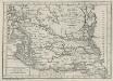
Charte von dem Kanal Franz des zweiten: Nach M. Votésky's Reduction von Ant. Quits Charte der Bácser Gespanschaft
1 : 510000 Landes-Industrie-Comptoir
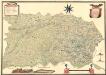
Bács-Bodrog vármegye térképe
1 : 450000 Kogutowicz, Manó Magyar Földrajzi Intézet
C. Torontal
Ungarn Serbien Komitat Torontal

Siedlungsgebiet der Deutschen nach dem Nachbarschaftsindex für das Komitat Bács-Kiskun 1980
Bács-Kiskun Deutsche, Siedlung Bottlik, Zsolt
Kroaten im Komitat Bács-Kiskun 1980
Bács-Kiskun Kroaten, Siedlung Bottlik, Zsolt
Siedlungsgebiet der Deutschen nach dem Nachbarschaftsindex für das Komitat Bács-Kiskun 1880
Bács-Kiskun Deutsche, Siedlung Bottlik, Zsolt
Kroaten im Komitat Bács-Kiskun 1880
Bács-Kiskun Kroaten, Siedlung Bottlik, Zsolt
Generalkarte von Zentraleuropa

Siedlungsgebiet der Deutschen nach dem Nachbarschaftsindex für das Komitat Bács-Kiskun 1941
Bács-Kiskun Deutsche, Siedlung Bottlik, Zsolt
A horvátok aránya és száma Bács-Kiskun megyében 1880-ban
Bács-Kiskun Kroaten, Siedlung Bottlik, Zsolt
Kroaten im Komitat Bács-Kiskun 1941
Bács-Kiskun Kroaten, Siedlung Bottlik, Zsolt
A horvátok aránya és száma Bács-Kiskun megyében 1941-ben
Bács-Kiskun Kroaten, Siedlung Bottlik, Zsolt
A horvátok aránya és száma Bács-Kiskun megyében 1980-ban
Bács-Kiskun Kroaten, Siedlung Bottlik, Zsolt
A németek településterülete a szomszédsági mutató alapján Bács-Kiskun megyében 1980-ban
Bács-Kiskun Deutsche, Siedlung Bottlik, Zsolt
A németek településterülete a szomszédsági mutató alapján Bács-Kiskun megyében 1880-ban
Bács-Kiskun Deutsche, Siedlung Bottlik, Zsolt
A németek településterülete a szomszédsági mutató alapján Bács-Kiskun megyében 1941-ban
Bács-Kiskun Deutsche, Siedlung Bottlik, Zsolt
C. Bacsiensis
Ungarn Komitat Bács-Bodrog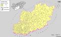
Serben in Süd-Transdanubien und im Komitat Bács-Kiskun 1980
Transdanubien (Süd), Bács-Kiskun, Serben, Siedlung Bottlik, Zsolt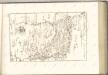
Mappa Der Grenz Scheidung Des Banat Temeswar Von Anno 1749 Mit Den Türken Geschlosen Von Herren General Feldmarschaů Lieutinont Freiheren Frantz Von Engelshofen A. 1749
Mollova mapová sbírka Geyer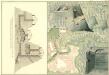
Plan des Bergwergs zu Lupkovo
Mollova mapová sbírka Geyer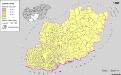
Serben in Süd-Transdanubien und im Komitat Bács-Kiskun 1880
Transdanubien (Süd), Bács-Kiskun, Serben, Siedlung Bottlik, Zsolt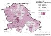
Vojvodina 1981. Jugoslawen (Jugosloveni)
Wojwodina ethnische Gruppe, Jugoslawen Hofinger, Veronika