Maps of Papua New Guinea
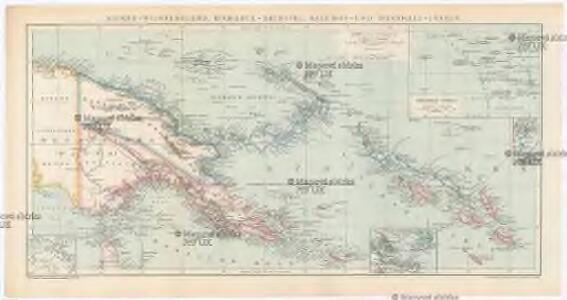
Kaiser-Wilhelmsland, Bismarck-Archipel, Salomon- und Marshall-Inseln
1 : 6000000 Bismarckovo souostroví F.A. Brockhaus' geogr.-artist. Anstalt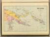
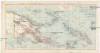
New Guinea & Solomon Islands.
1 : 5105520 Stanford, Edward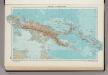
335. New Guinea, Solomon Islands. The World Atlas.
1 : 7500000 USSR (Union of Soviet Socialist Republics).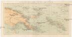
Kolonien (Schutzgebiete) des Deutschen Reichs
1 : 6000000 Marshallovy ostrovy F.A. Brockhaus Geogr.-artist. Anstalt
Nieuw Guinea en omgeving
1 : 8000000 Annotatie: Vrijgegeven door W.B.N. 29-3 '44 Den Haag : Kompas
Die deutschen Besitzungen im Stillen Ozean
1 : 3000000 Kiepert, Richard Geographische Verlagshandlung Dietrich Reimer
Schetskaart van Nieuw Guinea / Topografische Dienst
Topografische Dienst Batavia Batavia : Reproductiebedrijf Topografische Dienst
Nieuw Guinea / Topografische Dienst
Topografische Dienst Batavia Batavia : Reproductiebedrijf Topografische Dienst
Elf kaarten van Nieuw-Guinea / Directie Ned[erlands] Nieuw Guinea, Ministerie van Binnenlandse Zaken
Ministerie van Binnenlandse Zaken 's-Gravenhage . Directie Nederlands Nieuw Guinea ['s-Gravenhage : Staatsdrukkerij]
Schetskaart van Nieuw-Guinea / Topografische Dienst
Topografische Dienst Batavia Batavia : Reproductiebedrijf Topografische Dienst
Vegetatiekaart van Nieuw-Guinea
Topografische Dienst Delft Delft : Topografische Dienst
[Schetskaart van Nieuw-Guinea] / Topografische Dienst
Topografische Dienst Batavia Batavia : Reproductiebedrijf Topografische Dienst
[Nieuw Guinea] / Topografische Dienst
Topografische Dienst Batavia Batavia : Reproductiebedrijf Topografische Dienst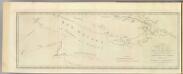
New Britain discoveries.
1 : 4500000 Hawkesworth, John, 1715?-1773
Kaiser-Wilhelmsland
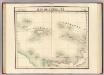
Iles de l'Amiraute. Oceanique no. 24.
1 : 1641836 Vandermaelen, Philippe, 1795-1869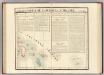
Partie, Nlle. Irlande. Oceanique no. 25.
1 : 1641836 Vandermaelen, Philippe, 1795-1869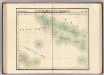
Partie, Iles Salomon. Oceanique no. 32.
1 : 1641836 Vandermaelen, Philippe, 1795-1869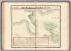
Partie, Nouvelle Guinee. Oceanique no. 31.
1 : 1641836 Vandermaelen, Philippe, 1795-1869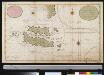
Nieuwe afteekeningh van Salomons Eijlanden of Isles de Salomon geleegen in de Groote Zuijd Zee. N.B. men segt dat de grond oft aertrijk deser eijlanden gout is
Solomon Islands Gerard van Keulen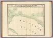
Partie, Nouvelle Guinee. Oceanique no. 23.
1 : 1641836 Vandermaelen, Philippe, 1795-1869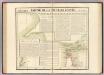
Partie, Nouvelle Guinee. Oceanique no. 30.
1 : 1641836 Vandermaelen, Philippe, 1795-1869
Geologische overzichtskaart van den Nederlandsch Oost-Indischen Archipel : Nederlandsch Nieuw Guinea [Zuid] / bewerkt door J. Zwierzycki
Landsdrukkerij Weltevreden (Batavia) [Weltevreden (Batavia) : Landsdrukkerij]
Languages of the Sepic Region, Papua New Guinea / D. Laycock
Australian National University Canberra [Canberra] : Australian National University
Languages : Eastern, Western and Southern Highlands Territory of Papua and New Guinea / by S.A. Wurm
[S.l. : Australian National University]
Languages : Eastern, Western and Southern Highlands Territory of Papua and New Guinea / by S.A. Wurm
[Canberra : Australian National University]
Bladwijzer van Merauke en omgeving
[S.l. : s.n.]
Bian-Rivier / prepared and reproduced by Base Map Plant USASOS SWPA, December 1942 - January 1943, from a Dutch map printed by Topografische Dienst (Topographic Service) Batavia, 1941
Base Map Plant USASOS SWPA [S.l.] : Base Map Plant USASOS/SWPA
Merauke / prepared and reproduced by Base Map Plant USASOS SWPA, December 1942 - January 1943, from a Dutch map printed by Topografische Dienst (Topographic Service) Batavia, 1941
Base Map Plant USASOS SWPA [S.l.] : Base Map Plant USASOS SWPA