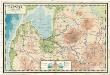
Maps of Pskovsky District

Dorpat, Pskow, Ostrow
1 : 750000 Pskov (Rusko) K. u. k. Militärgeographisches Institut
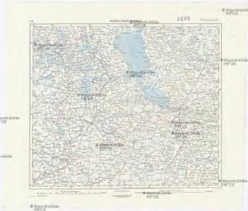
Ostland 1:100 000
1 : 100000 Estonsko OKH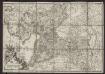
Der Pernausche Kreis = Le cercle de Pernau
1 : 300000 Mellin, Ludwig August 1754-1835 [Riga] : [J.F. Hartknoch]
DVCATVVM LIVONIAE et CVRLANDIAE cum vicinis Insulis Nova Exhibitio Geographica
1 : 917000 Estonsko Homann, Johann Baptist Ioh. Baptista Homanno
Dvcatvvm Livoniae et Cvrlandiae cum vicinis insulis nova exhibitio geographica
1 : 895000 Estonsko Homann, Johann Baptist Ioh. Baptista Homanno
Estland-Letland-Litauen
1 : 2200000 Den Haag : Kompas
Livoniae et Curlandiae ducatus cum insulis adjacentib. mappa geographica
1 : 1900000 Estonsko Seutter, Matthäus Drentwett, Abraham per Matthaeum Seutter
Estland, Lettland und Nordwestrußland
1 : 2500000 Estland, Lettland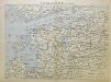
Von Riga nach St. Petersburg
1 : 2600000 Baltikum
Russia Part lII.
1 : 1770000 Society for the Diffusion of Useful Knowledge (Great Britain)


Esthland, Livland, Kurland vom Frieden von Stenby 1238 bis zur Abtretung des Dänischen Theils von Esthland an den Deutschen Orden 1346
1 : 6000000 Baltikum
Skizze des Vormarsches der 8. Armee in Livland und Estland
1 : 1050000 Baltikum Weltkrieg <1914-1918> Verl. Gerhard Stalling, Oldenburg
Tabula ducatuum Livoniae et Curlandiae
1 : 1000000 recentior incisa editaque per Gerardum Valck [Amsterdam] : per Gerardum Valck
Esthland, Livland, Kurland nach ihren kirchlichen Verhältnissen im Mittelalter
1 : 6000000 Baltikum Kirchengeschichte
Übersichtskarte von Liv-, Est- und Kurland
1 : 1000000 Baltikum Weltkrieg <1914-1918> Verl. Gerhard Stalling, Oldenburg
Esthland, Livland, Kurland zur Zeit des Schwertordens 1201 - 1237
1 : 5000000 Baltikum Schwertbrüderorden
Livonia
1 Karte : Kupferdruck ; 35 x 46 cm Mercator; Hondius sumptibus Henrici Hondij
Topographische Charte von Liw-Laett u. Eestland zu Anfang des 13ten Jahrhunderts
Estonsko
Dvcatvvm Livoniæ et Cvrlandiæ cum vicinis insulis nova exhibitio geographica
1 Karte : Kupferdruck ; 47 x 56 cm Homann Johann Baptist Homann
Dvcatvvm Livoniæ et Cvrlandiæ cum vicinis insulis nova exhibitio geographica / editore Ioh. Baptis
1 : 910000 1 Karte : Kupferdruck ; 47 x 57 cm Homann, Johann Baptist [Johann Baptist Homann]
Esthland, Livland, Kurland in den Jahren 1346 bis 1480
1 : 6000000 Baltikum
Esthland, Livland, Kurland 1480 bis 1682
1 : 6000000 Baltikum
Ducatuum Livoniae et Curlandiae novissima tabula in quibus sunt Estonia Litlandia et aliae minores provinciae
1 : 970000 1 Karte : Kupferdruck ; 47 x 56 cm Danckerts, Justus [Danckerts]
Ost-See Provinzen.
1 : 1370000 Grassl, J. (Joseph)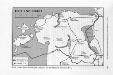
Estland 1918/19
Estland
Das Deutschtum II. 1.
Baltikum Ethnische Gruppe, Deutsche
Lettland
1 : 420000 Lotyšsko Endzelin, J. Karthographischen Institut A. Ošinš & P. Mantnieks