Maps of Oldenburg-Land
Ostsee
1 : 100000 Dánsko Reichs-Marine-Amt
Het Zuijdelijkste gedeelte van de Beld, van de Riv. Sleeswijk tot t eijl. Femeren
Germany Gerard van Keulen
11. Wester-Markelsdorf, uit: Topographische Uebersichtskarte des Deutschen Reiches / herausgegeben v. d. Kartogr. Abt. d. Königl. Preuß. Landesaufnahme
1 : 200000 titelvariant: Topogr. Übersichtskarte des Deutschen Reiches; Annotatie: Titel boven bladen ook: Topogr. Übersichtskarte des Deutschen Reiches; Annotatie geografische gegevens: Op elk blad twee maatstokken: 10 Kilometer = 5,5 cm; 1 geogr. Meile = 3,6 cm; Legenda onder op elk blad Königlich Preußische Landesaufnahme. Kartographische Abtheilung [S.l : Königlich Preußische Landesaufnahme, Kartographische Abtheilung]
Een gedeelte van de kust van Holsteijn van Kijll of Kielerford tot Femere of New Stadt in de Belt Oost Zee
Germany Gerard van Keulen
39. Kappeln. (Germany)
1 : 100000 Reichsamt fur Landesaufnahme
Composite: 59. Lutjenburg. (Germany)
1 : 100000 Reichsamt fur Landesaufnahme
Composite: 40. Wester-Markelsdorf. (Germany)
1 : 100000 Reichsamt fur Landesaufnahme
58. Kiel. (Germany)
1 : 100000 Reichsamt fur Landesaufnahme
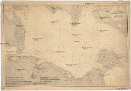
SYLVA DANICA | vulgo | DÆNISCHEN WALDE.
[Amsterdam : Joan Blaeu]
Composite: 58. Kiel. (Germany)
1 : 100000 Reichsamt fur Landesaufnahme
59. Lutjenburg. (Germany)
1 : 100000 Reichsamt fur Landesaufnahme
Composite: 39. Kappeln. (Germany)
1 : 100000 Reichsamt fur Landesaufnahme
40. Wester-Markelsdorf. (Germany)
1 : 100000 Reichsamt fur Landesaufnahme
60. Oldenburg i/Holst. (Germany)
1 : 100000 Reichsamt fur Landesaufnahme
Composite: 60. Oldenburg i/Holst. (Germany)
1 : 100000 Reichsamt fur Landesaufnahme
FIMBRIÆ, | Vulgo | FEMEREN | DELINEATIO | GEOMETRICA.
[Amsterdam : Joan Blaeu]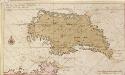
Afteekening vant eijland Femeren geleegen aen de zuijtwal in de Belt
Germany Gerard van Keulen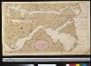
Afteekening van de Rivier van Sleeswijck waer bij dessefls incomen int grood wort vertoont geleegen in de Beldt
Germany Gerard van Keulen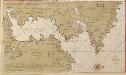
Afteekening van Kieler Fioerd en Christian Hafen
Germany Gerard van Keulen
Kiel und kieler Föhrde
1 : 50000 Kiel (Německo) F.A. Brockhaus' geogr.-artist. Anstalt
Kieler Hafen
1 : 55000 Kielský záliv (Německo) Bibliogr. Institut
Meßtischblatt 367, neue Nr. 1632 : Grossenbrode, 1879
1 : 250000 Grossenbrode. - Aufn. 1877, hrsg. 1879. - 1:25000. - [Berlin]: Reichsamt für Landesaufnahme, 1879. - 1 Kt.
Meßtischblatt 366, neue Nr. 1631 : Heiligenhafen, 1879
1 : 250000 Heiligenhafen. - Aufn. 1877, hrsg. 1879. - 1:25000. - [Berlin]: Reichsamt für Landesaufnahme, 1879. - 1 Kt.
Meßtischblatt 365, neue Nr. 1630 : Hohwacht, 1879
1 : 250000 Hohwacht. - Aufn. 1877, hrsg. 1879. - 1:25000. - [Berlin]: Reichsamt für Landesaufnahme, 1879. - 1 Kt.
Meßtischblatt 363, neue Nr. 1629 : Giekau, 1936
1 : 250000 Giekau. - Hrsg. 1879, kleine Nachtr. 1918. - 1:25000. - [Berlin]: Reichsamt für Landesaufnahme, 1936. - 1 Kt.
Meßtischblatt 363, neue Nr. 1628 : Bendfeld, 1879
1 : 250000 Bendfeld. - Aufn. 1877, hrsg. 1879. - 1:25000. - [Berlin]: Reichsamt für Landesaufnahme, 1879. - 1 Kt.
Meßtischblatt 362 : Friedrichsort, 1916
1 : 250000 Friedrichsort. - Aufn. 1877, hrsg. 1879, Auflagendr. 1916. - 1:25000. - [Berlin]: Reichsamt für Landesaufnahme, 1916. - 1 Kt.
Meßtischblatt 361 : Kiel, 1916
1 : 250000 Kiel. - Aufn. 1877, hrsg. 1879, Auflagedr. 1916. - 1:25000. - [Berlin]: Reichsamt für Landesaufnahme, 1916. - 1 Kt.
Meßtischblatt 1626 : Kiel, 1879
1 : 250000 Kiel. - Aufn. 1877, hrsg. 1879. - 1:25000. - [Berlin]: Reichsamt für Landesaufnahme, 1879. - 1 Kt.