Maps of Bar Municipality

Adriatisches Meer, Küsten-Karte
1 : 180000 Jaderské moře (oblast) Oesterreicher, Tobias von Hydrographisches Amt der k. u. k. Kriegs-Marine
[Nordalbanien]
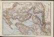
Albanien
Scutari
1 : 200000 Shkodër (Albánie) Militärgeographisches Institut
Isole e fortesse Venezia
Albanien Venezia (bis 1797) Befestigung
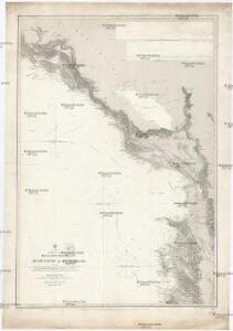
Umgebung des Skutarier Sees und die Zadrimaer Niederungen
Albanien Skutarisee Péch, Béla
Übersichtskarte von Skutari
1 : 1000000 Albanien Shkodër
Karta od Crnegore
1 : 290000 Černá Hora Buza, Vasal L. Förster's Anstalt
Der Doppelhafen von Cattaro
1 : 100000 Boka Kotorska
Okolí Kotoru
1 : 140000 Kotor (Černá Hora) Bedřich Sandtner
Okolí Kotoru
1 : 140000 Kotor (Černá Hora) Fáborský, Jan B. Nipočić, Vasilij Bedřich Sandtner
Kreis Cattaro
1 : 144000 Kotor (Černá Hora) L.W. Seidel
Kreis Cattaro
1 : 140000 boka Kotorská (Černá Hora) Artaria
[Umgebung von Kotor]
Montenegro Kotor Umland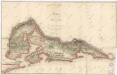
Karte der Bocche di Cattaro

Budua und Cetinje.
from Spezialkarte der osterreichisch-ungarischen Monarchie.
Bojanamündung
Albanien Makedonien Bojana (Fluss)
Bojiště v Dalmácii
1 : 146000 Dalmácie jižní (Chorvatsko) Ed. Grégr
Mappa del Cordone Sanitario del Circolo di Cattaro
Kotor (Region) Cordon sanitaire , Relief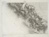
Spizza.
from Spezialkarte der osterreichisch-ungarischen Monarchie.
Durazzo

Buchta Boko-di-Kataro
Montenegro Kotor Seeschlacht
Carte du théâtre de l'insurrection des Bouches de Cattaro
1 : 143400 boka Kotorská (Černá Hora)
Busen von Cattaro
1 : 500000 Boka Kotorska
Umgebung von Cattaro

Umgebung von Cattaro

Cattaro.
from Spezialkarte der osterreichisch-ungarischen Monarchie.
Carte des BOUCHES de CATTARO et du MONTENEGRO
1 : 49000 boka Kotorská (Černá Hora) Traux, Maximilian de Stein, Carl Artaria et Comp.
Übersichtsblatt zum Kriegsspielplan der Umgebung von Cattaro
1 : 12500 Kotor (Černá Hora) K. u. k. militär-geographisches Institut
Situation vor Skutari in der ersten Hälfte März
1 : 100000 Albanien Shkodër Balkankrieg <1912-1913> Belagerung von Shkodër <1912-1913> Siegrist, Ed.